Apr 12, 2009 - MERCHANTS MILLPOND. Northern NC. Rented a canoe ($14 for 4 hours). Lassiter Swamp, Bennett's Creek. Turtles. Bald cypress trees & their "knees" are so neat.
Apr 11 - OUTER BANKS, NC. Oregon Inlet Campground. Bodie Lighthouse. National Seashore beach.
Apr 10 - BEAR ISLAND from Hammocks Beach SP HQ. Much wider & better marked than route from Shell Rock. Lagoon.
Apr 9 - BEAR ISLAND from Shell Rock Landing. See dolphins as we get ready to launch. Cross Intracoastal Waterway. Brown canoe trail marker posts thru marshes. Up the Trout Channel along the island to Ferry dock - ranger told us middle of island closed due to heavy machinery on beach (backcountry campsites also closed) so we headed back to W end of island ~low tide. Sandy bluffs & dunes, very scenic. Bear Inlet very narrow route out to Ocean. Tricolored herons, egrets. Very shallow in spots on way back (even 4 hours after low tide for Bogue Inlet), we also take a wrong turn for short time.
Apr 8 - WHITE OAK RIVER from Cedar Point. Estuary, over a mile wide, now a couple of miles before the river meets the ocean, tidal. Also explored Dubling & Boathouse Creeks. Clammers. Tricolored herons. Undeveloped on E shore & islands, W side developed.
Apr 7 - WHITE OAK RIVER & tributaries from Haywood Landing. River averages 100' wide here. To Long Point & back - also explored Mulberry & Grants Creeks. Fire in evidence in pines on E shore, Croatan NF. Undeveloped shores. Wood ducks, turtles, osprey, prothonotary warblers.
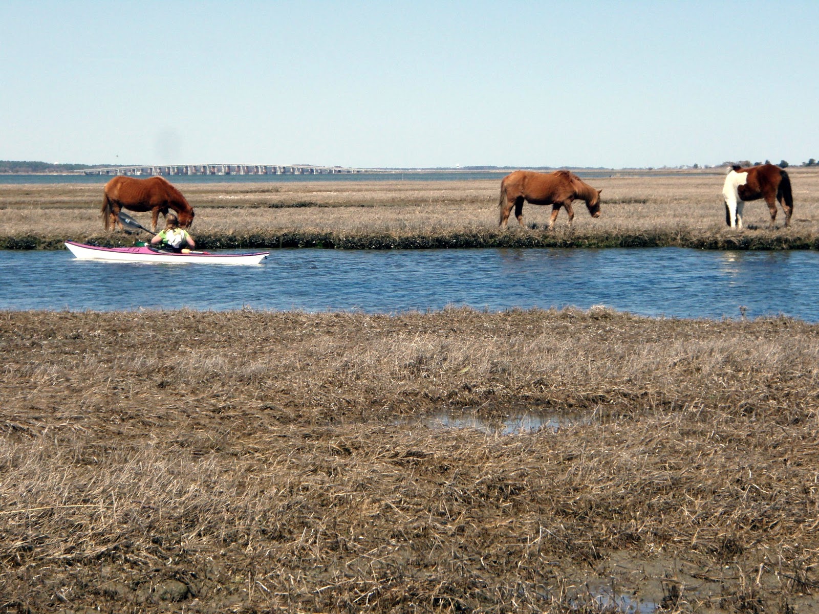
Apr 5 - ASSATEAGUE, MD. Chincoteague Bay. Wild horses, little blue heron, loons.
Apr 6-13, 2008 - NC kayaking, Neuse River & Swansboro area. WS Tempest 170, a 17' polyethylene touring kayak.
Apr 13 - BOGUE SOUND. From Hoop Pole Woods (behind closed Hardee's & shopping center) in Atlantic Beach. Marshy islands at the start, many oyster beds. Headed W on the sound, very shallow at low tide. Shores mostly developed after the marshes. 8 miles.
Apr 12 - WHITE OAK RIVER. Upstream from Haywood Landing boat launch. Explored some feeders incl. Holston Creek. Turned around at power line. Water snake.
Apr 11 - HUGGINS ISLAND. From Bear Island, marked trail around Huggins then to the visitor center. Most of the islands between the barrier islands & the mainland are marshy (saltmarsh cordgrass), Huggins has a maritime forest & lies at the mouth of the White Oak River. Drove to Cedar Point campground, our base for rest of trip - convenient, some road noise, not much privacy.
Apr 10 - BEAR ISLAND. Trout Channel on N side of the island to a sandy beach at Bear Inlet. Got lost for over an hour in a maze of channels trying to follow the marked trail to Shell Rock Landing. Egrets, tricolored herons, black skimmers.
Apr 9 - BEAR ISLAND. Get camping permit & launch from Hammocks Beach SP Visitor Center. 3-mile marked trail thru marshy islands to Bear, a shallow channel leads into a lagoon & landing near campsite #7 - we have to walk the beach to site #6 which is in the dunes. From our site, it is a 10 min. beach walk to restroom/shower building. Atlantic Ocean surf zone - played/practiced, got wiped out when I didn't edge enough into a large breaking wave & lost my prescription sunglasses because in the excitement I had forgotten to attach Croakies & floater. Bottlenose dolphins, brown pelicans, jellyfish (washed up on the beach).
Apr 8 - GREAT LAKE. In the heart of Croatan NF. About 2 x 3 miles - paddled most of the perimeter - some small sandy beaches on E shore - coffee-colored water. Windy - waves to 1.5'. No development - wilderness shores - pocosin (raised bog) habitat - shapely trees in water. Osprey nest. 8.7 miles, 3.5 hrs.
Apr 7 - BRICE CREEK. From NC Wildlife Resources Commission boat ramp to SR 1111 bridge & back. Paddled upstream, explored many inlets & side-channels. Osprey with fish in claws & nest. Mostly undeveloped, W shore is in Croatan NF. 14.9 miles.
Apr 6 - NEUSE RIVER upstream from Seven Springs. Noticeable current. White, yellow & pink blossoms. Cliffs of the Neuse rise 70' above. Above the cliffs explored a swampy inlet with interesting bald cypress trees. Mostly undeveloped. Watch out for poison ivy on shore. Deer. 10.8 miles, 4.5 hrs. Drove to Neuse River campground - nice, fairly private sites, nearby sandy beach, got some great paddling maps of Carteret County from campground host.


Apr 18-23, 2004 - NE NORTH CAROLINA kayaking. General: First 3 nights we camped inland at Pettigrew State Park on Phelps Lake - small campground among tall bald cypresses & huge sycamores (some had hollowed out trunks that you could walk into), good hot showers, a few mosquitoes, snake (green rat snake or chicken snake); the next 2 nights we camped at Oregon Inlet Campground at the Cape Hatteras National Seashore (on Bodie Island, as are the towns of Nags Head, Kill Devil Hills & Kitty Hawk) - 5 min. walk across dunes to the Atlantic, exposed & windy, cold showers, no bugs. Water temp. in creeks & sounds in the 60s, high 40s on the ocean; air temp: daytime highs 75-85, lows around 60. No rain all week - just sun & more sun - winds generally 10-15 knots from the SW (gusts can be higher). Best guidebook: Guide to Sea Kayaking in North Carolina by Pam Malec (has all below trips except for Scuppernong), also useful: Sea Kayaking the Carolinas by Bannon & Paddling Eastern North Carolina by Ferguson.
Apr 18 - SCUPPERNONG RIVER - tall bald cypresses, loblolly pines, tupelo, blackgum, dogwood, Carolina ash, butterflies, water snakes, tons of turtles, pileated woodpeckers, cardinals, a gb heron. Mistletoe growing on some of the deciduous trees. Concrete ramp put-in next to Spruill's bridge on Main St. east of the village of Creswell. Paddled downstream 6 miles then returned - river is about 60-100' wide at start & widens slowly downstream. Wooden platforms are located every few miles for rest stops since shores are swampy. Mostly undeveloped, pristine shores except at bridges. 5.5 hrs.
Apr 19 - ROANOKE SOUND . Winds from SW 15-20 knots. First put-in at a kayak launch area on the Nags Head side near Headquarters Island - paddled down some deadend channels & cornered a cormorant - too windy out on the exposed sound. Drove across the bridge to Roanoke Island where there is a boat launch with multiple concrete ramps & an osprey nest nearby. Paddled S & pulled off on a small beach & just hung out on a hill enjoying the view. Brown pelicans fly by. Wide channels lead thru the marsh. Little development on S half of the island (city of Manteo is on N end of the island). Pick up map with put-ins at visitor center on island's W side on Rt.64.
Apr 20 - SAWYER LAKE & MILLTAIL CREEK in the ALLIGATOR RIVER NATIONAL WILDLIFE REFUGE . Headed up a channel & into pretty Sawyer Lake then back past put-in & downstream on Milltail Creek. Soon saw an alligator - didn't see its tail but figured it must be 6-7' long. Bald cypress, pines, some grasses - trees smaller than on Scuppernong. Saw another alligator. Made it to the Alligator River (part of the Intracoastal Waterway) which is about 5 miles wide at this point - vocal ospreys in a nearby nest - swampy shore makes for lousy landings for a break. Saw wood duck mom with chicks on way back. 12 miles, 6 hrs. A must-do trip if you are in these parts - undeveloped except for a run-down camp. Another trip report & pics.
Apr 21 - PEA ISLAND NWR on Pamlico Sound from New Inlet. Rt. 12 bridge from Bodie to Pea Island then 7 miles to sandy put-in site. Great egrets, oystercatcher. Windy, but we did a reasonably good job of hiding behind the many marshy islands - waves up to 1.5'. Average water depth just 2'. MAP.
Apr 22 - JEAN GUITE CREEK to CURRITUCK SOUND . Mix of marsh & swamp at concrete ramp put-in on Bob Perry Rd in Kitty Hawk. Great & snowy egrets, poisonous cottonmouths (water moccasins), turkey vultures, deer, ospreys, prothonotary warbler, killer catfish. The cottonmouths we saw were much fatter than the other water snakes & had a very definite pattern on top - they just headed for land when we approached. Undeveloped shores til we paddled under a covered bridge - area is part of a preserve, Kill Devil Woods, & is a prime example of a maritime forest. Light development on creek beyond. Fancy homes as creek widens into the sound N of Rt.158 bridge but this is where we saw many ospreys. Creek is about 4 miles long but open at each end (Kitty Hawk Bay to the S).
Apr 23 - LITTLE COLINGTON ISLAND & KITTY HAWK BAY morning paddle. Put-in at a small sandy spot 3 miles W of Rt.158 & the Wright Bros Memorial. Paddled under bridge & S on channel then E into the sound & around a point. Heading N again on Colington Creek we pass under another road bridge & enter Kitty Hawk Bay. Stop at a sandy beach near tip of Little Colington which had some interesting palm-like vegetation & pines. Wound our way thru some marshy islands then looped back to start. 7 miles, 2.3 hrs. Minimal development on Little Colington but Kill Devil Hills/Kitty Hawk Bay shores are mostly developed. After the paddle, picked up some super sandwiches at Ocean Bread on the main drag & went over to a town beach on the ocean side where we saw dolphins - surf was small & seas were relatively calm & it would have been perfect for an ocean paddle but we had to be off on the long drive home (600+ miles to APnP).
NWK Synergy HV kayak paddled nicely, not especially fast for a kayak of its length but very predictable in waves, didn't use the rudder at any point. Aquabound AMT Carbon paddle broke at the ferrule - 2nd one I've seen this happen to so we probably will not be stocking the carbon version in the future - Aquabound has reduced the weight of this paddle over the last couple of years but I feel they have compromised its durability. Used Werner Rec Tour paddle most of trip & is a very nice paddle in the same price/weight range as the Aquabound AMT Carbon - have never had any problems with Werners. Thermalwear not needed except if paddling on the ocean - wore non-cotton shorts/shirts & watershoes most of trip - wore Chota Mukluks the 1st day but were too hot.


Comments
Post a Comment