Posts

Showing posts with the label Bog River

WINDING (aka PA'S) FALLS, BOG RIVER xc skiing
Image
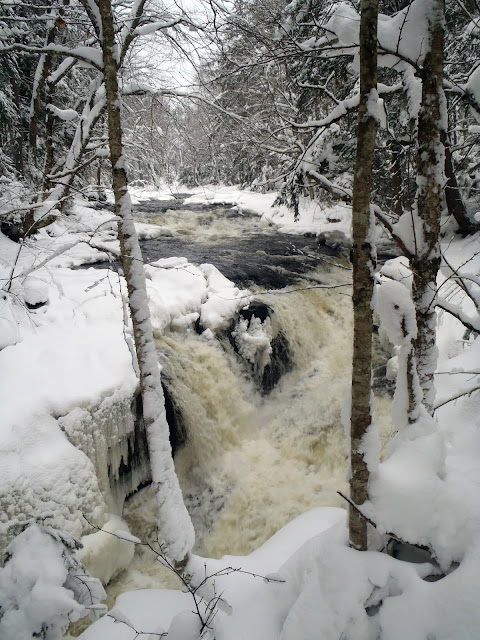
Mar 16, 2015 - PA'S (aka WINDING) FALLS. Bog River Ski Trail.  Jan 6, 2013 - PA'S FALLS ON THE BOG RIVER. 20" - much powder over a wettish base. Bridge over Round Lake Stream. S of the bridge an old road passes the sites of the "Bog River Hilton" & other camps that the state removed soon after purchasing the land eventually reaching a gate at the edge of state land - some blowdown. NW of the bridge an old road (now also canoe carry for those doing the Whitney Loop) goes up over a hill for 2 miles before reaching the bridge over the Bog River. Crossed the bridge & skied downstream a bit to the spectacular falls - lots of water dropping over 20' between icy rock walls. 6+ hours.  Dec 30, 2007 - PA'S & SPLIT ROCK FALLS, BOG RIVER on unmarked trail from Rt.30 (0.2 miles S of Rt.421). 20" in the Tupper Lake area - bit of an icy crust made for more challenging skiing. 1.5 miles on rolling hilly terrain, soon reach Bog River then follo...
3 SCENIC PADDLES WITH HIKES IN THE ADIRONDACKS

Image
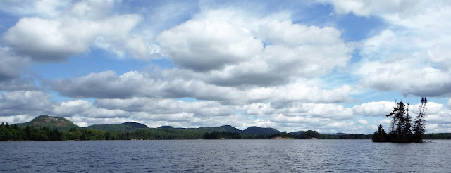
On online forums and social media, one often sees requests for suggested combination paddle and hike trips – the combination allows us to expand our experiences and also gets us to exercise a greater variety of muscle groups in the process. Examples I have often seen mentioned online are combinations like Long Pond and Long Pond Mountain in the St. Regis Canoe Area, Putnam Pond and Treadway Mountain in the Pharaoh Lake Wilderness, as well as Lake Lila and Mount Frederica in the Whitney Wilderness. A great view, in my opinion, should include at least one water body like a pond or lake, and have minimal sights and sounds of civilization. I have quite a number of favorites in this category and I have picked three of them to tell you about here. GARNET LAKE Garnet Lake is a 2-mile-long lake in the southern Adirondacks. Although there is some development at the north end of the lake, the southern half is fairly wild and most of it is state land. The put-in is at a small sandy bea...

LOWS LAKE, BOG RIVER, HITCHINS POND paddling, camping, hiking.

Image
Where to park, etc.: The Boy Scout camp on Lows Lake/Bog River is closing for good: article . Oct 8, 2024 - The New York State Department of Environmental Conservation (DEC) today announced that the gate on the access road leading to the Bog River Dam, also known as Lows Lower Dam, has reopened following a period of closure for dam maintenance. The Lower Dam Road and parking area near the end of the road are now open to the public. Sep 21, 2017 - LOWS RIDGE. Biked thru fenland to Lows Upper Dam. A Sunday, so was surprised to hear the generator going - no work being done on Sat/Sun. Hiked over 1 mile to the ridge, gaining 400'. Can see part of Lows Lake from the W end. Excellent views mostly S & E - the Bog River & Hitchins Pond below, High Peaks in the distance (Whiteface>Marcy), Blue & Wakely further S. Sep20, 2017 - BOG RIVER & HITCHINS POND from Lows Lower Dam. Love the avenue of the pines at the start. Poked into Hitchins inlet marsh to the S -...

BOG RIVER - HITCHINS POND canoeing. Adirondack Park.

Image
The New York State Department of Environmental Conservation (DEC) today announced that the gate on the access road leading to the Bog River Dam, also known as Lows Lower Dam, has reopened following a period of closure for dam maintenance. The Lower Dam Road and parking area near the end of the road are now open to the public. More Info . May 3&4, 2015 - BOG RIVER canoe camping from Lows Lower Dam.  The gate at the start of the dirt road to the dam had been opened just a day or 2 ago.  Side-trip of 1.3 miles up Horseshoe Lake outlet to Horseshoe Lake Rd, 2 beaver dams.  Hitchins Pond campsite #6.  1.3 mile (one way) hike from HP up to Low's Ridge (gain of 400') with lots of trout lilies blooming - awesome view with Bog River below & snowy Marcy & Algonquin in the far distance.  Full moonrise.  Saw a few other people, most heading out.  Day 2 - Paddled the perimeter of Hitchins poking into inlet at N end for a quarter mile.  Then, 1 mil...