Posts

Showing posts from January, 2023

MOOSE POND xc skiing in the High Peaks Wilderness

Image
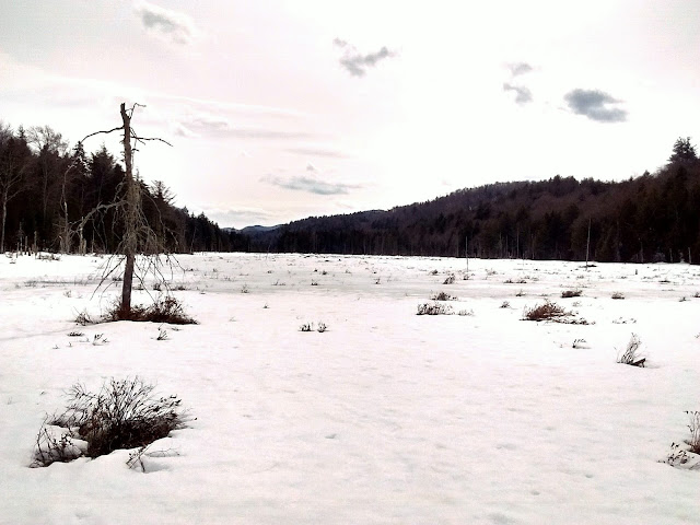
  Jan 22, 2023 - MOOSE POND ski. A few inches of base with a few inches of powder - could not ask for anything better. The trail was broken all the way altho I believe we were the only ones to reach the pond on this Sunday. Gentle rolling terrain most of the way on old roads. After the junction with the trail to Newcomb Lake, there is a good uphill with Moose Mtn towering 1000' above to the left, then a nice downhill to the pond bearing left to get to the campsites. Unfortunately, low clouds obscured Santanoni Peak & the Ermine Brook Slide as we sat on a downed tree eating lunch at the edge of the pond near a campsite. No wind, very quiet. Cloudy with temp in the upper 20s. I was feeling almost beat over the last couple of miles, but it actually took us less time on the return to the start. Elevations range between 1600' & 2000'. 15 miles, 1500' gross el gain, 6 hours.    Mar 19, 2012 - CAMP SANTANONI.  Took a walk on the carry trail to check out the rapids.  To

BUCK MEADOW FLOW hiking & skiing.

Image
  Siamese Ponds Wilderness, Adirondack Park, NY. Jan 14, 2023 - It has been a poor season for snow with recent rain. S on the trail past Old Farm Clearing (still some old stonework there from the farm) - the first 1.2 miles was packed-hard snow & easy walking. S of the clearing the E Br Sac trail was washed out in spots. 2 miles from the trailhead, we went off-trail, generally in a WSW direction, following some new & old flagging. Crunchy, sometimes supportive snow, 0-15" in depth. Lost the flagging (once again) & made our own way to the flow where we found more flagging paralleling the flow - we would have liked to continue S & try to find the Tin Camp but were worried about time & energy. After lunch, we followed the flagging NNE & lost it again, so brought out the compasses & GPS. Most the off-trail route from that point was thru open hardwoods & fairly easy going - much better than the flagged route. Came out onto the red Puffer Pond trail ~0.1

HOFFMAN NOTCH WILDERNESS skiing & snowshoeing.

Image
  The 38,488-acre Hoffman Notch Wilderness is located northwest of Schroon Lake-it is bordered on its east by the Adirondack Northway (I-87), on the north by Blue Ridge Road, and Hoffman Road to its south. For the winter adventurer, the area offers some easy to moderate trails to check out on skis or snowshoes, as well as some special rewards for the explorer who is willing to venture off the official trails.  While the area has in the past had just 15 miles of officially-marked trails, that is about to change with a new route that will travel over Jones Hill while connecting the Big Pond Trail to the Dirgylot Hill trailhead. This will also become a section of the North Country National Scenic Trail (NCT).  The trail-less Blue Ridge Range and its highest point, 3,693-foot Hoffman Mountain, dominate the landscape, however, there are several small peaks in the area that might be attractive to the seeker of views. In the southeast corner of the wilderness area and just north of the hamlet

BREIA cross country skiing

Image
  BREIA - Black River Environmental Improvement Association. Conditions . Jan 4, 2016 - Egypt Rd area. Jan 17, 2016 - BREIA Jackson Hill ski. Dec 20, 2015 - BREIA skiing (finally!) from Egypt Rd in Alder Creek (~25 miles N of Utica). Good to very good skiing on 10-15"; mostly powder, some wetness below. Some breaking trail, nothing groomed, parking lots not plowed. Trails: Glacier (intermediate), Link (novice), Great (novice) to past powerline, back to Link, Rim (novice, scenic), Gully I II III IV (steeper, int+, fun, went down IV & II), Creek View (novice). Lost my GPS. 4+ hours. Mar 17, 2013 - BREIA SKYFIELDS TRAILS ON JACKSON HILL from Jackson Hill Rd in Boonville.  A 50K system of trails free to the public.  Excellent skiing on 3" powder over good base with a hint of crunchiness.  Track set on most of the trails.  Elevations 1,100' to over 1,600'.  Telemark Hill Lodge warming hut - deluxe.  Telemark Field & Trail - great for turns.  Down to Canal Trail (mo