HOFFMAN NOTCH WILDERNESS skiing & snowshoeing.

The 38,488-acre Hoffman Notch Wilderness is located northwest of Schroon Lake-it is bordered on its east by the Adirondack Northway (I-87), on the north by Blue Ridge Road, and Hoffman Road to its south. For the winter adventurer, the area offers some easy to moderate trails to check out on skis or snowshoes, as well as some special rewards for the explorer who is willing to venture off the official trails.
While the area has in the past had just 15 miles of officially-marked trails, that is about to change with a new route that will travel over Jones Hill while connecting the Big Pond Trail to the Dirgylot Hill trailhead. This will also become a section of the North Country National Scenic Trail (NCT).
The trail-less Blue Ridge Range and its highest point, 3,693-foot Hoffman Mountain, dominate the landscape, however, there are several small peaks in the area that might be attractive to the seeker of views. In the southeast corner of the wilderness area and just north of the hamlet of Schroon Lake, a 1.2-mile trail leads up Severance Mountain/Hill while gaining over 700 feet in elevation-this can be a nice half-day hike for some views of the lakes to the south and east. There are four other trailheads that access the wilderness area.
The Hoffman Road trailhead is located 2.2 miles west of US 9. The Big Pond Trail starts out from a small parking area and a register is soon seen on the left. After going about 1 mile, you may be able to spot the new trail that heads up Jones Hill on the right. Soon after that point, you should be able to see Big Pond down through the trees on your left. At the 1.6-mile mark, a trail leads left to a campsite above the pond. Provided that the pond is well-frozen, one can head south across the pond and enjoy a view of the Blue Ridge Range to the north..jpg)
.jpg)
The trail up until the pond is fairly gentle but gets hillier past the campsite turn-off. The next section between the pond and the junction with the Hoffman Notch Trail is not traveled much in summer, let alone in winter-that may change in the future when more folks decide to explore portions of the NCT.
For a time in the late 20th century, the Wills Run Ski Touring Center occupied an area to the south of the pond and you may discover some trails in the vicinity-just be aware of what is state land and what is private. The #743 National Geographic Trails Illustrated map shows the wilderness boundary, or you can view it online at the DECinfo Locator https://www.dec.ny.gov/pubs/109457.html.
The Loch Muller trailhead is at the north end of Loch Muller Road, which heads north off Hoffman Road. In winter, the road is usually only plowed to a plow turn-around point and 0.25 miles short of the summer trailhead. One should park alongside the road away from the turn-around. The Hoffman Notch Trail heads north and reaches the trailhead at Blue Ridge Road in close to 8 miles. The southern half of the route is over rolling terrain and stays close to the North Branch of Trout Brook. Big Marsh is about halfway and is usually the goal and turn-around point for in-and-out trips from either direction. Skiing out onto Big Marsh, actually, a fair-sized beaver pond reveals wondrous views of the surrounding mountain ridges. I generally try to find a spot in the sun and out of the wind for a leisurely lunch break here.

The Bailey Pond Trail leaves the Hoffman Notch Trail not far from its southern trailhead, and reaches the pond in about 1 mile. Staying well away from the outlet, you can head out onto the frozen pond and admire your surroundings as the looming rocky mass of Hayes Mountain dominates the scenery ahead. Two winters ago, a group of us continued by skiing through semi-open woods to the south and up to a lookout on Cobble Hill after an elevation gain of 600 feet from the pond. Most “normal” winter adventurers may prefer to snowshoe up this trail-less route. And don't forget, that with snow on the ground, you can always follow your tracks back to the start, so it is hard, although not impossible, to actually get lost.

The northern Hoffman Notch trailhead is on Blue Ridge Road, 5.7 miles west of the Northway's Exit 29. The parking area is on the north side of the road. The first part of the trail goes through private land and crosses some streams on good bridges. The trail then gains over 500 feet in the next 2 miles. I always make a point to go off-trail a bit to get to the bottom of a spectacular icefall that comes down off Washburn Ridge. The terrain alternates between moderate climbs and flatter sections. Again, Big Marsh is the usual destination. The ski back down should be an exhilarating experience for the strong intermediate skier..jpg)
.jpg)
The Dirgylot Hill trailhead is on US 9, 1.6 miles north of its junction with NY 74 near the Northway's Exit 28. This trailhead provides access to the eastern part of the wilderness area. Follow the arrows to a tunnel under the Northway and then bear left to continue on a woods road to a T intersection with another woods road at the 0.7-mile mark.

After taking a right at the T, the woods road soon ends, but a path, marked only with ax blazes on the trees, continues through woods of large white pine and eastern white cedar until it again comes out onto an old woods road. This less-distinct old road climbs uphill between the Peaked Hills and Wyman Hill and roughly parallels Seventeenth Brook which can be heard down below to the right. This area is best for those who are comfortable with off-trail travel and are well-versed in map and compass skills. Last winter, a group of us skied up to a remote pond located west of Wyman Hill and, in the process, encountered a lot of blowdown that needed to be skirted. Bushwhackers will find excellent views from the top of the “hills”.

If you take a left at the aforementioned T, the woods road will eventually lead to private land. However, a right turn well before reaching Platt Brook will put you on the new trail up Jones Hill. Last winter, this route was marked with flagging (surveyor's tape) but will eventually have official DEC and NCT markers. The route passes around the south side of Smith Hill before crossing Platt Brook, then meanders its way up Jones Hill and its wonderful views-a net ascent of 1,000 feet in about 3.5 miles. I am sure this will become a very popular hike once the route is officially marked and the word gets out to the hiking public.
As you can see, the Hoffman Notch Wilderness offers quite a variety of options for adventuring in winter that range from short and easy escapes from civilization to challenging and imaginative forays into wild lands. Maps, directions to trailheads, and more information can be found on the NYSDEC website at https://www.dec.ny.gov/lands/81598.html .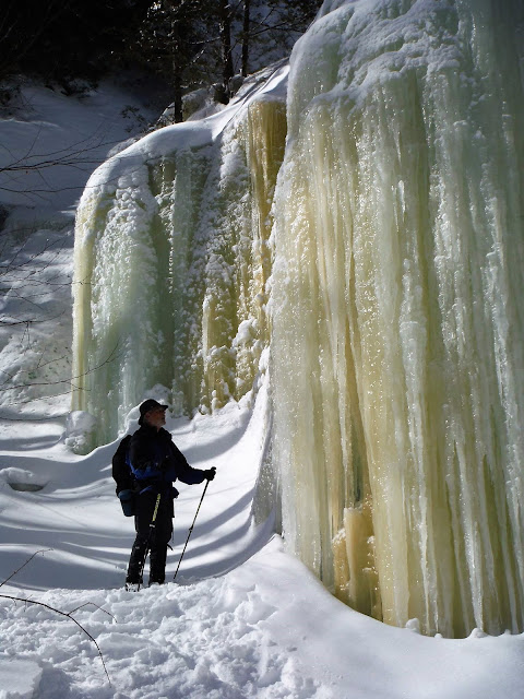
.jpg)


.jpg)

Feb 10, 2008 - HOFFMAN NOTCH & BIG MARSH. Over a foot of base with over a foot of powder - excellent. Headed N from Loch Muller. Pleasant stretch next to a stream, several dips into stream crossings (good snow bridges generally), many short ups & downs, some blowdown. Nice mountain views from the pond at Big Marsh - Hoffman Mt rises over 2,000' above, Texas & Washburn Ridges with snow-covered trees. Marten, grouse. Intermediate. Fischer Rebound skis. 8 miles, 5 hours.


Comments
Post a Comment