Posts

Showing posts from March, 2019

KAYADEROSSERAS CREEK paddling, Saratoga County NY

Image
I enjoy getting away from civilization and always look forward to visiting the wild areas of the Adirondacks. However, in most years, Adirondack waterways do not become ice-free until at least the middle of April and many ponds and lakes may not open up until the end of the month. There are several good options in the lowlands outside of the park though - the Kayaderosseras Creek in Saratoga County is one of them. One can paddle the Kayaderosseras (most folks pronounce it Kay-duh-ross) as a one-way downstream trip or do an up and back trip from one launch spot. Spring water levels are usually good and there is some current – it may be a bit more work paddling upstream but you can be assured that the return downstream will be easier. Before you paddle the “K”, check out the website of the Friends of the Kayaderosseras (https://kayadeross.org/) for any updates and information on their spring clean-up days on April 28 and May 4. From Rock City Falls to Ballston Spa, the creek i

CEDAR RIVER ELM ISLAND & McGINN MOUNTAIN XC skiing.

Image
Article - click here 1/28/21 - CEDAR RIVER, PASHLEY FALLS, ELM ISLAND from the end of Pelon Rd in the hamlet of Indian Lake. Blue Mountain Wild Forest. Bear L on snowmobile trail which soon turns L - we bear R on Cedar River Loop Trail following yellow xc ski markers. It does not take long to make one feel into the wilds. The Cedar is fairly flat here & was iced over. Reach scenic Pashley Falls at 1.4 miles which is more rapids than falls. The trail then heads SE thru balsam firs & drops to a 4-way junction at the 1.9-mile mark where we took a L on the Elm Island Trail, marked with blue xc ski markers. Uphill for a while then rolling, balsams transition to hardwoods. Sharp drop & an unofficial Elm Island sign is seen on the L - EI is actually a mile further at the end of the trail. Up over the shoulder of McGinn Mtn & a few sharp drops (the last was brushy) to where the Cedar makes a 90-degree turn to the W, at 4.5 miles. A small gorge is seen upstream, do

WOLF POND snowshoing, hiking, canoeing, camping. Vanderwhacker Wild Forest, Adirondack Park.

Image
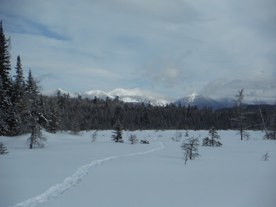
Mar 3-5, 2019: WOLF POND snowshoeing & lean-to camping. Vanderwhacker Wild Forest, 3 miles S of Boreas Ponds. Hard snowshoe-packed trail, narrow, very twisty & turny with lots of ups & downs - would like to have skied it but not with a heavy load, probably intermediate+ in the best of snow conditions. New trail with red markers,NE-facing lean-to is only a couple of years old. Mostly evergreen woods, balsam fir dominant. 4"-8" powder on deep crunchy base. 2.4 miles to pond & lean-to, some interesting ice on rocky area half way. High Peaks view to the N - Redfield (4,606'), Skylight (4,926'), Marcy (5,344'), Haystack (4,960'), Basin (4,827'), Saddleback (4, 4,528') Mountains; glimpse of Gothics from west side of pond; to the NE, Boreas (3,776') & Wolf Pond Mountains are nearer. Could not find the thunderbox under 4' of snow & possibly a downed tree. Grouse. Owners of nearby private land came out on snowmobile - chat