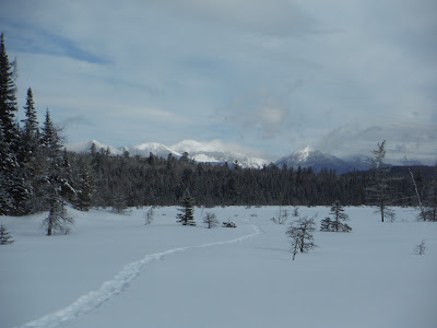

Mar 3-5, 2019: WOLF POND snowshoeing & lean-to camping. Vanderwhacker Wild Forest, 3 miles S of Boreas Ponds. Hard snowshoe-packed trail, narrow, very twisty & turny with lots of ups & downs - would like to have skied it but not with a heavy load, probably intermediate+ in the best of snow conditions. New trail with red markers,NE-facing lean-to is only a couple of years old. Mostly evergreen woods, balsam fir dominant. 4"-8" powder on deep crunchy base. 2.4 miles to pond & lean-to, some interesting ice on rocky area half way. High Peaks view to the N - Redfield (4,606'), Skylight (4,926'), Marcy (5,344'), Haystack (4,960'), Basin (4,827'), Saddleback (4, 4,528') Mountains; glimpse of Gothics from west side of pond; to the NE, Boreas (3,776') & Wolf Pond Mountains are nearer. Could not find the thunderbox under 4' of snow & possibly a downed tree. Grouse. Owners of nearby private land came out on snowmobile - chatted with them for a few minutes - you can see their lodge to the south when you go out into the middle of the pond.


April 24, 2017 - WOLF POND backpack from Boreas Rd. Vanderwhacker Mountain WF. New trail (flagged but does not have disc markers yet) & new lean-to. Wolf Pond is 3 miles S of Boreas Ponds. Start at the campsite just E of the Boreas River bridge. Trail soon crosses Wolf Pond outlet on a new bridge & stays close to the stream for 0.4 miles with some patches of snow then climbs away. Mostly snow-free for the next mile but quite a bit of blowdown, high & dry, no mud. Last mile thru woods dominated by balsam fir was over 50% snow, sometimes over a foot, some postholing. 2.4 miles to lean-to, rolling terrain, did not expect that much snow in the last mile, slow going. Lean-to has a filtered view of the pond; from pond's edge Boreas & Wolf Pond Mnts stand out to the NE. Could still hear distant road noise at times, the pond is less than a mile from the road as the crow flies. Pond mostly open, just a little ice left. Walked to the outlet, good High Peaks view along the way. Trail was marked with flagging to a 3-log bridge over the outlet, opted not to cross (I have been on the other side & High Peaks views are great). Loons were quite vocal after sunrise. Grouse. No bad bugs. 5.6 miles.


Aug 18, 2014 - WOLF POND from Blue Ridge Rd. Started ~1 mile E of the Boreas River, there is a turnout on S side of road. Brutal bushwhack (esp. with canoe overhead) N for a quarter mile but I hit the outlet below the bend in the stream when flow changes from S to W. Over a beaver dam, then reach rapids. Carried 200 yds on the R (river L), scouted 1st then went back for canoe & pack, could not see a path so fairly nasty. Back on flatwater the shallow stream widened & had grass & lily-pads, couple of beaver dams. At rapid, carried on river L on rough path, much nicer than whacking, & soon arrived at WP with its magnificent High Peaks view (Redfield, Skylight, Marcy, Haystack, Saddleback, Basin). Felt like 3 hours to get here but actually only 1.25 miles in 1.4 hours. An overgrown 4WD "road" leads to private land, a rowboat stashed by the pond. Paddled around the pond & into islands of bog with turtlehead, pitcher plants, sundews. On the return, continued downstream past the point where I had initially entered the outlet wanting to avoid the longer whack. Stream wide & shallow again. Reached the top of a rapid & whacked S uphill for 200 yds & I was on Blue Ridge Rd (half mile E of Boreas River bridge). Half mile road walk E to get the Nehasanemobile. 5.3 miles, 4.5 hours.


Comments
Post a Comment