BOREAS PONDS in the Adirondack Park
June 20-22, 2023 (Tue-Thu) - BOREAS & WHITE LILY PONDS paddling, hiking, & camping. High Peaks Wilderness. Highs in the 70s, lows in the upper 40s. Light mosquito activity at times, a moderate amount of young deer flies (not biting), and black flies are over with (they are hanging out on cooler mountain tops).
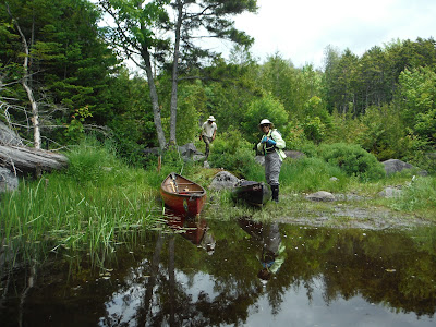
Day 1 - Drove 6 miles on Gulf Brook Rd (dirt/gravel) to the 4 Corners parking area (5 of the 15 spots were taken). Wheeled the boats ~1 mile on dirt/gravel road to the lean-to, white-throated sparrows sang along the way, & set up camp. Saw a ruffed grouse in the lean-to clearing. Wild strawberries too. There is a well-hidden thunderbox privy - it took a while to find it - it is in another clearing NW of the lean-to. The Ranger stopped by as we had lunch. Paddled the irregular perimeter of BP. Spotted a loon on a nest. Great blue heron. 5.7 miles. Saw a few other paddlers, mostly day trippers. Went for an evening paddle.
Day 2 - A snapping turtle decided to lay some eggs not far from the lean-to. Paddled to the N end of BP & hiked to WLP on old logging roads - we took the route described by Phil Brown (https://www.adirondackalmanack.com/.../hiking-logging... - the final path was about 0.2 miles & no longer had blue flagging) & got to the pond in 55 mins - there were moose tracks almost all the way. At WLP there were views of Allen Mtn & Cheney Cobble if one moved around. Found a shortcut route back (yellow markers at each end) & it only took 40 mins to get back to BP. Paddled in & out & around the islands (some with heavy spruce growth like most of the shoreline, some are just low & boggy) back to camp. 8.5 miles combined paddling & hiking, 6 hours. Saw only 2 other boats.
Day 3 - Went for a short morning paddle then packed up & wheeled out. On the drive out, stopped at LaBier Flow to check out the view & the new bridge - it is 4-5' higher than the old one. Also stopped at one of the designated primitive car camping sites.
May 2023 - The Boreas Ponds Lean-to offers the only designated camping location on Boreas Ponds currently. Prior to DEC's construction of the 2 designated campsites on Boreas Ponds, primitive camping must be done at least 150' from the shoreline. Signage is installed, at impacted sites within 150' of the shoreline, to remind campers not to use these areas and camp at an appropriate distance. Thank You for helping protect the natural resource and the Wilderness Experience of all future users by following the 150' rule when selecting a site! The 2018 High Peaks Wilderness Complex UMP Amendment allows for 2 designated waterway access sites to be built and the work planning for those projects is underway. Gulf Brook Road remains closed through May 26 while construction crews work on Labier Dam. Motor vehicles can access Gulf Brook Road into the Four Corners Parking area starting 5/27. Boreas Road between Four Corners Parking Area and Boreas Ponds Parking Area will remain closed for repairs.
Oct 2022 - Boreas Ponds Tract: A temporary bridge was installed over the LaBier Flow Dam on Gulf Brook Road in the Boreas Ponds Tract, restoring access to the Four Corners Parking Area at the terminus of Gulf Brook Road for pedestrians and motorists.
Sept 2022 - You can drive Gulf Brook Rd to the Fly Creek parking area, about halfway to the ponds - leaving a 2.7-3.7-mile carry to get to the flow/ponds. I believe one of the issues is that the bridge over LaBier Flow outlet is undrivable. When the road is reopened it will be posted here.
Sep 4 & 5, 2016 - BOREAS PONDS canoe camping. 5 other cars in the new parking area. Wheeled canoe & gear 2.7 miles to the put-in on LaBier Flow just past the dam.
Scenic 0.7-mile paddle to take-out in a small cove, marked with a 2.5' stick stuck in the ground. 50' carry to the road. Wheeled half mile to the dam at the ponds. Outstanding High Peaks views; plus North River Range/Cheney Cobble to the W & Boreas Mtn to the E. Cruised the ponds & looked for a good campsite without luck; mostly spruce & fir, shores are hard to land on. Peaceful evening with cricket, owl & loon sounds. Misty morning. Loons (8 incl. 2 chicks), 3 otters. Paddled up the inlet (Boreas River), had to carry around a culvert, crossed an old logging road, continued 0.7 miles upstream winding thru a vly. Went for a swim near the dam. Skipped paddling LaBier on the way out & wheeled 3.7 miles, a bit more gentle but tiring uphills on the way back. 23.9 miles over 2 days. Saw 3 other canoes & 1 kayak on the ponds, several hikers & some bikers on the road. Some biting stable flies while on the water (very little wind), mosquitoes came out for ~10 minutes at dusk.Saw a woman on shore taking photos with a long telephoto lens, months later I saw this photo of me by Nancie Battaglia in Adirondack Explorer:

.JPG)
.JPG)
.JPG)
.JPG)
.JPG)
.JPG)
.JPG)
.JPG)

.JPG)

.JPG)
.JPG)

.JPG)
.JPG)
.JPG)
.JPG)
.JPG)

.JPG)

.JPG)
.JPG)
.JPG)
.JPG)


Comments
Post a Comment