Posts

Showing posts from 2023

SUCKER BROOK PRESERVE hike, northeast of Lake George

Image
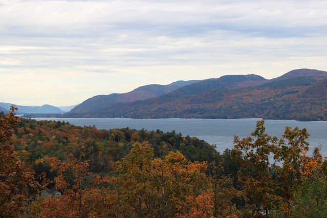
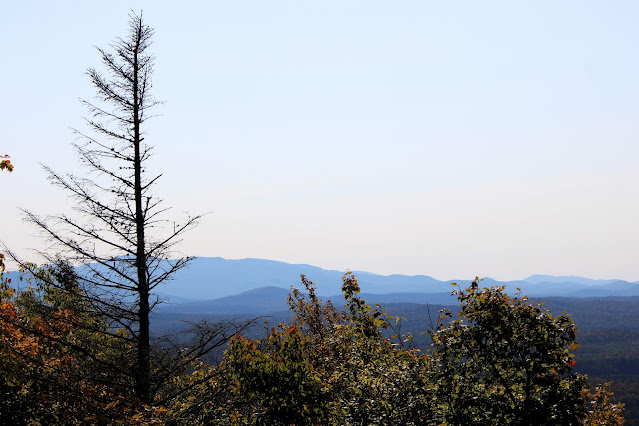
  Oct 24, 2023 - SUCKER BROOK PRESERVE, on the NE shore of Lake George, formerly known as Gull Bay and Last Great Shoreline Preserves, LGLC . Started from the Sagamore Rd parking area. Map at the kiosk (I had also downloaded it to my phone earlier). Blue trail 0.4 miles to the first lookout of the day, & a fine one it was looking S on Lake George with the Tongue Mtn Range across the other side. Orange trail with views of wetlands. Red spur crosses Sucker Brook (which flows S to N thru the preserve) & climbs to a ledge with a view overlooking wetlands & mountains beyond. Yellow trail (shown as green on the map) to yellow trail N (part old woods road, part rugged single-track with wood steps). R on blue, R on red to a small view to VT, lunch. Down to blue, & down, sometimes steeply to the lake - nice views from the dock, limited view from the bench at the lookout. Back up to yellow & S to start. Elevations ranged from 320' to 630'. Left some trails for another

MERCK FOREST hiking, skiing, & cabin camping in Vermont

Image
  Merck Forest & Farmland Center website Oct 10, 2015 - MOUNT ANTONE hike. Merck Forest & Farmland Center, VT. Went up the direct way via Antone Rd (a wide fairly smooth trail) - 2.5 miles; 800' climb. Wonderful views to the distant Adirondack High Peaks from a lookout past the actual summit - foliage close to peak - red-tailed hawks. Steeply down on the Beebe Pond Trail then L past Ned's Place cabin & its view of Mt Equinox, then Lourie Trail back to Antone Rd & out past the farm with more Adk views - 3.2 miles out. 4+ hours. Mar 9 - MERCK FOREST. Mount Antone. Mar 8, 2015 - MERCK FOREST. Gallop Peak. Feb 19, 2014 - MERCK FOREST.  Temp in 20s to low 30s.  Gain of 800' to  Mount Antone (el 2,610') took 1.5 hours, trail broken out - very windy & snowing, no view today.  S on Masters Mountain Trail, a fairly wide trail with no recent use so had to break trail in 30" of powder - after a short moderately steep climb we dropped 1,600', steeply th

FLOODWOOD MOUNTAIN hike

Image
  Sep 21, 2023 (Thu) - FLOODWOOD MOUNTAIN hike. Interesting drive on dirt roads - there are a couple primitive campsites before the parking area. The hike starts on the continuation of the dirt road, soon come to a gate. At 0.7 miles the route turns R off the dirt road. There was a pile of lumber here destined for boardwalk to be placed over a long muddy area ~0.25 miles further up the trail. Gentle at first, the trail gets steeper the further you go. Woods are exclusively hardwoods (maples, beech, yellow birch) until close to the top. At the actual summit (2304') there is a small view E - we could see Rock Pond where we had paddled the day before . Continuing on an unmarked path beyond the summit, one eventually comes out some open rock with a wide view to the S - could see the S end of Rollins Pond, Wolf Pond, Tupper Lake, Blue Mtn, Mt Arab, & Mount Matumbla. No bad bugs, temp rising thru the 50s to mid-60s, fall foliage starting to look good. 4 miles, 790' gross el gain,

MIDDLE SARANAC LAKE & WELLER POND paddling

Image
  Sep 18, 2023 (Mon) - Put in on South Creek off Rt. 3. Short distance N to Middle Saranac & kept heading N (W end of the lake has private shores with a few camps) to the channel that leads into Weller. There was a small group of canoers camping at the lean-to on the E side of Hungry Bay. Paddled around the edge of WP & stopped at the lean-to for lunch - this one is new & on a nice spot with a filtered view of the water, the old one was a bit closer to the water. Headed back to the channel, saw a loon, & soon took a L & into round Little Weller. Back to MSL, saw 2 loons, headed past islands toward where the Saranac River exits the lake, Ampersand & Stony Creek Mtns in view with the Sewards in the distance, a group with kayaks & a moboats was camping nearby. Went quite a ways down the wide river with buoys (motors are allowed) but turned around before reaching the lock. Back to start past more islands. No bad bugs. The forecast was not promising but we ended

SHALLOW LAKE hike & canoeing

Image
  Apr 29&30, 2012 - SHALLOW LAKE & SUCKER BROOK canoe camping.  Pigeon Lake Wilderness Area.  1.3 mile carry from Lower Browns Tract Pond.  Trail rough at first then got worse as it got wet & muddy passing thru swamp on either side of Beaver Brook.  Bridge over the latter has bouncy 3 log stringers at water level.  Paddled down the brook half mile to large boggy area.  Last 0.9 miles of trail better but not without its muddy spots.  Aluminum canoe at the end of the trail.  Very windy with waves over 1'.  Paddled around E end & settled into an excellent campsite amongst white pines with a long rocky point & commanding view of the lake.  4 hours from the start & the partying began.  There are at least 3 other campsites on the lake (did not like 2 of those).  Great wilderness feel, very quiet.  Wind finally died down in the evening - the next day was much calmer - temp dropped into the 20s overnight.  Paddled down Sucker Brook the outlet for half an hour portag

MASON LAKE paddling & camping in the central Adirondacks

Image
  Aug 24 - Car camped at MASON LAKE for 2 nights - sites 1-4 were occupied so had to take #5 near the outlet which had a picnic table & firepit but no privy - close enough to the lake to hear loon calls. Broke camp Thursday morning then paddled this small lake with an irregular shoreline. 1 loon, gb herons, ducks; road noise from NY 30. The best part was the outlet where I found cranberries, pitcher plants, pickerelweed, & jewelweed & smartweed on a beaver dam at the end of navigation. 1.6 hours. July 18, 2005 - MASON LAKE. Camped at drive-in site on Perkins Clearing Rd (dirt) near the outlet of the lake. Hazy morning paddle - nice setting marred only by the proximity of Rt.30. 2 adult loons dove & rose to feed 2 growing but still fuzzy-looking chicks. Boggy shores along the outlet offered much interest - pitcher plants, sundews, bladderwort's yellow flowers; white fragrant & yellow pond lilies in the shallows. Visit us on Facebook Welcome to the Adirondacks NYS

FISHING BROOK, RICH LAKE, COUNTY LINE LAKE paddling

Image
  Aug 23, 2023 - RICH LAKE & FISHING BROOK paddling. Most of the shoreline is owned by ESF - obey any "No Trespassing" signs. You can drive down the access road (dirt), drop off your stuff, & drive back to the parking area off Rich Lake Lane. Easy 200' carry to the beach. Paddled W across the lake, saw a loon, & entered the pickerelweed-lined S channel. Took a R thru a narrow channel, slid over a beaver dam, & into the main channel of Fishing Brook. Paddled upstream & was shocked to see that the bridge had been replaced by a dam with several culverts (not sure if this was done before or as a result of the July 10/11 high water event - Phil Brown mentions a bridge in his 2019 edition of the guidebook) - heavy machinery was working in the area, so we turned back. Over 2 small beaver dams & then along the N shore of RL. Lots of cedars line the shore with some white pines, cardinal flower was ubiquitous, and bottle gentian at our lunch stop. The 2 trai