LOWS LAKE, BOG RIVER, HITCHINS POND paddling, camping, hiking.
Where to park, etc.:

The Boy Scout camp on Lows Lake/Bog River is closing for good: article.
Oct 8, 2024 - The New York State Department of Environmental Conservation (DEC) today announced that the gate on the access road leading to the Bog River Dam, also known as Lows Lower Dam, has reopened following a period of closure for dam maintenance. The Lower Dam Road and parking area near the end of the road are now open to the public.
Sep 21, 2017 - LOWS RIDGE. Biked thru fenland to Lows Upper Dam. A Sunday, so was surprised to hear the generator going - no work being done on Sat/Sun. Hiked over 1 mile to the ridge, gaining 400'. Can see part of Lows Lake from the W end. Excellent views mostly S & E - the Bog River & Hitchins Pond below, High Peaks in the distance (Whiteface>Marcy), Blue & Wakely further S.


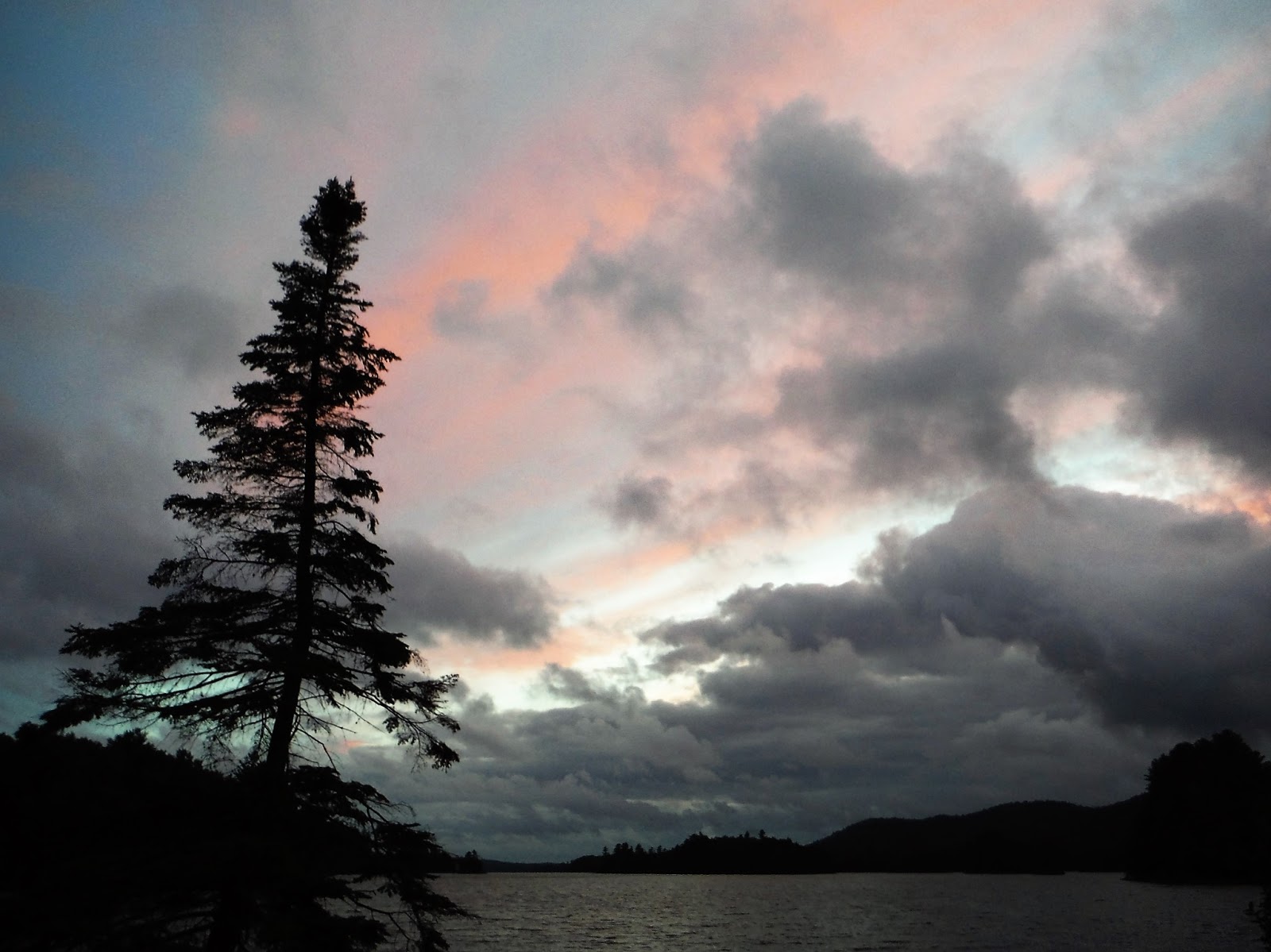
May 3&4, 2015 - BOG RIVER canoe camping from Lows Lower Dam. The gate at start of the dirt road to the dam had been opened just a day or 2 ago. Side-trip of 1.3 miles up Horseshoe Lake outlet to Horseshoe Lake Rd, 2 beaver dams. Hitchins Pond campsite #6. 1.3 mile (one way) hike from HP up to Low's Ridge (gain of 400') with lots of trout lilies blooming - awesome view with Bog River below & snowy Marcy & Algonquin in the far distance. Full moonrise. Saw a few other people, most heading out. Day 2 - Paddled the perimeter of Hitchins poking into inlet at N end for a quarter mile. 1 mile up unnamed stream S going over about 10 beaver dams & approaching the rr tracks - turned around where a stream (outlet of Little Trout Pond) comes in from the E thru a culvert under the tracks. Day 2 had gusty winds, both days temp in the 70s. Mosquitoes, bald eagles, loons, osprey, otters, deer; also sounds of grouse drumming, woodpeckers tapping, spring peepers - no sign of blackflies. Leatherleaf blooming at water's edge. Took a quick refreshing clean-up dip at the take-out. On the drive out: there was a spine of snow to the side of CR 421 so I got out the skis.


 Aug 16, 2010 - BOG RIVER from Lower Dam to Bog River Falls. A couple of thunderstorms passed thru early while we were in camp but rest of the day ended up real nice - had time to solo (using kneeling thwart) the kevlar Bell Northstar canoe & explore the N end of Hitchins Pond. Dropped off camping gear at the cars & spotted a car at Bog River Falls on Rt.421. In contrast to yesterday's route this section will need a few years to see a 100 paddlers, we saw no-one. The river has mostly wooded shores - mainly alders & spruce but also some very tall white pines & some hardwoods. From the dam we carry on river R past the powerhouse to the flat water below. All carries after this are on river L - expect to step over logs, etc. Soon come to a short rapid which we lined. At the next & longer rapid a rough carry trail well-marked with ribbons goes steeply up before leveling out somewhat. Ceebotar & Oceebota had a royalex canoe & decided to line instead of carry. The next carry starts above Split Rock Falls, rough at first it soon takes a R on an old logging road which leads to an old bridge. I have skied much of this area & am somewhat familiar with the paths. From the bridge the carry continues alongside the river passing a campsite & soon bears L at a red marker to the pool below Pa's Falls. Bearing R at the fork leads to the best view of the falls & is a great spot for a break. Here the river drops & turns R shooting down thru vertical rock walls, the roar of the water makes it difficult to carry on a conversation - a great spot. After a short paddle across the pool there are 2 shorter carries (not as well-marked, stay close to the river). Good stretch of flat water follows & a sign for the Bog River Ski Trail is seen on the L. We go over a couple of beaver dams. We almost miss the start of the next & longest carry which follows the ski trail with views of the river. Eventually the ski trail turns L along an old logging road while the carry trail jogs L & R. Occasionally could not see the next ribbon & the path is little used so one has to pay attention so as to not get lost. We arrive at the river just above the confluence with Round Lake Outlet. Flat water for last 1.75 miles to take-out. 5.4 hours for the trip from the Lower Dam to BR Falls. No bad bugs except for a few mosquitoes in camp.


Aug 15 - BOG RIVER, HITCHINS POND, LOW'S RIDGE from the Lower Dam. This is a paddlers' superhighway - probably saw close to 100 other paddlers (half canoes half kayaks, motors not allowed) either coming or going (most headed to & from Low's Lake). Most campsites early on on the Bog River & Hitchins were available mid-day Sunday & we chose #4 because it has room for 3 tents & it is away from the traffic. Paddled over to start of the Upper Dam portage. From there it is ~1.25 mile hike to the lookout on Low's Ridge - great views of the Bog River & distant High Peaks from the open rocks. Loons, black ducks - others saw a bald eagle & a swimming red squirrel.
Sep 4, 2008 - LOWS LAKE to OSWEGATCHIE RIVER. 0.8 mile carry from Lows to Big Deer Pond fairly smooth, one short steep hill some beaver flooding near end - took 20 mins. Moose footprint. 3 loons. Blue ribbons marked the start of 2.2 mile Headwaters Carry to the O. Mostly smooth & flattish. Crossing on an old beaver dam, then mailbox with register, then moderate uphill, downhill, then mostly smooth & flat, last section a bit rougher thru area highly impacted by 1995 blowdown. Lots of piles of bear scat in trail. Lows to O in under 3 hours. We work our way downstream for 5 miles going over many beaver dams & log obstructions (on one we had to remove packs from canoes to get over the tree). Stopped to look at most campsites - most good for 1 or 2 tents. Ended up at Camp Johnny #11, room for our 4 tents, rock overlooking river, only campsite of trip with no privy.
Sep 3 - LOWS LAKE, GRASS POND MTN. Hike up to the open rock on GP Mtn very well marked with ribbons, steep but takes less than an hour to viewpoint (see Discover Northwestern Adirondacks). Walked W of main viewpoint to where I could see Grassy Pond, bald eagle, ravens & hear loon calls. Lay my head down on small rock cairn - everything was just right - Nirvana! Swam, relaxed in camp. Sunset paddle. After dark could see flashes of lightning to the SE; above our heads nothing but stars & milky way.
Sep 2 - CLEAR POND to LOWS LAKE. Carried directly from campsite N to dirt road, L for a short distance then R on an older dirt road (closed to vehicles) to landing on Bog Lake. The campsite nearby is nice. Paddled around W end of lake then down the outlet. Bald eagle flies overhead; lots of C geese in outlet (Bog River). Out onto Lows, we take the sneak route to E of the bog & look for a campsite on N of lake. Settle on #26 - squeeze in 4 tents near the water, box privy, view across bay to eagle's nest, Grassy Pond Mtn, view S across lake from lookout. Shallow sandy bottom good for swimming out to island. Sunset paddle. Lots of loons.


On a previous kayaking trip, we saw a bear swimming in the middle of the lake!
Sep 3 - LOWS LAKE, GRASS POND MTN. Hike up to the open rock on GP Mtn very well marked with ribbons, steep but takes less than an hour to viewpoint (see Discover Northwestern Adirondacks). Walked W of main viewpoint to where I could see Grassy Pond, bald eagle, ravens & hear loon calls. Lay my head down on small rock cairn - everything was just right - Nirvana! Swam, relaxed in camp. Sunset paddle. After dark could see flashes of lightning to the SE; above our heads nothing but stars & milky way.
Sep 2 - CLEAR POND to LOWS LAKE. Carried directly from campsite N to dirt road, L for a short distance then R on an older dirt road (closed to vehicles) to landing on Bog Lake. The campsite nearby is nice. Paddled around W end of lake then down the outlet. Bald eagle flies overhead; lots of C geese in outlet (Bog River). Out onto Lows, we take the sneak route to E of the bog & look for a campsite on N of lake. Settle on #26 - squeeze in 4 tents near the water, box privy, view across bay to eagle's nest, Grassy Pond Mtn, view S across lake from lookout. Shallow sandy bottom good for swimming out to island. Sunset paddle. Lots of loons.

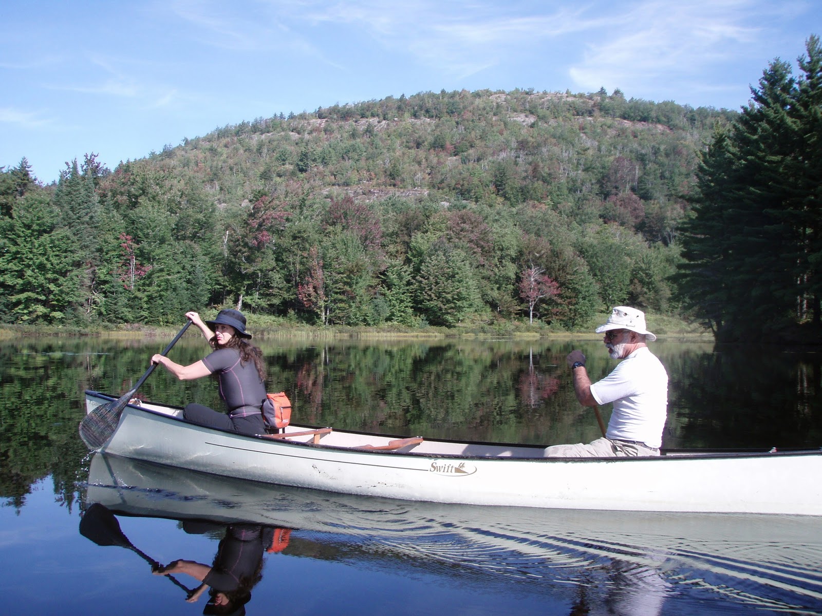


July 7, 2002 - Bog River & Lows Lake kayaking. Area is SW of Tupper Lake. Put-in at the Lower Dam - lots of vehicles in small parking area & along sides of the 0.8 mi. dirt access road. Sunny but extremely hazy day - high altitude winds were bringing smoke from Quebec forest fires our way. It is a beautiful 3 miles to Hitchins Pond & the carry (100-200 yds depending where you take out) around the Upper Dam - able to make the carry in a single trip with the cockpit slung over the shoulder (kayak is only 42lbs. + ~20lbs of gear). Soon come to a floating bog that is jammed in a narrowing of the river - paddled thru a narrow gap on the R (river L). Pitcher plants & blue flag were flowering; look closely for sundews; a 2' snapping turtle hung out on a log. Sheep laurel is flowering on the banks. Passed a lot of campers heading out. The river slowly becomes wider & we duck thru a gap on the S shore & paddle along a long island - water shallow in spots. Stop at campsite 13 for lunch (incl. ibuprophen) with good view 5 miles down Lows Lake. Followed N shore as turkey vultures soared overhead & into Grass Pond, the N arm of the lake. Admired the cliffs on Grass Pond Mt. & landed on a sandy beach for a soothing swim. Pumped some drinking water using a First Need Purifier - this thing is fastest filter I know of but a bit on the heavy side. Took a slightly different route back, helped on by a tailwind, waves up to 1' (expect waves up to 2' if wind is blowing over 15mph from the SW). As we passed campsite 28, a dark object was moving in the middle of the lake - too big & dark for a loon (of which we saw many). It didn't take too long to realize it was a big black bear - this was the highlight of the trip (unfortunately I only brought my short zoom & took shots with an 80mm lens - sure wish I had brought along my 300mm.) We made sure not to surround it & gave it an escape route. (Think it had its sights on some sloppy campers on the N shore - always hang up your food when away from camp & at night.) Back on the river we saw a couple of deer. 24 miles, 8.5 hrs. Swift Caspian Sea, a 15.2' fiberglass touring kayak, worked out very well - cruised along with longer sea kayaks (I had the shortest boat of the group), easily controlled going into wind & waves, ever-so-slight corrections needed in waves with a quartering tailwind but no skeg or rudder was needed (the rest of the kayakers did use theirs, tho.) Felt a bit unconfortable with a bit of lower back pain (always a problem with kayaking) at about the 20 mile mark but that went away over the last 4 miles. We traded Werner paddles & general consensus was: Mid-tour (a budget version of the Camano) was too heavy compared to the rest & splashy like the Camano; carbon-fiber Kalliste with bent shaft was real sweet on entry & exit, hand placement not best for me but still felt great while cruising; standard Kalliste is a great paddle all-around - most of us thought a carbon-fiber, straight shaft version would be the paddle to have; the Kauai was a shorter, high-angle, more aggressive stroke paddle which was good but a bit splashy - used it to vary my paddling style so as not to strain the same muscles over & over on a long trip. Hung around afterwards with Hombrua & Arsonis at campsite #1 near the Lower Dam for more beer testing (it's a tough job but someone has to do it) & lively conversation. Most of day bug-free; some deerflies & horseflies at the carry; mosquitoes out in early morning & around dinnertime. No motorboats or floatplane landings today. Moonless sky cleared beautifully - multitude of stars, milky way, etc. - wished I was camping on Lows & listening to the loons call - a great day nonetheless.
Sep. 27, 2001 - Big Trout Lake hike & lower Bog River paddle. Spent the night at Lake Eaton State Campsite near Long Lake - a scratchy throat early in the week had developed into a full-blown sore throat & I wanted a warm shower, restroom & clean running water - only about 6 other campers. No loons seen or heard on Lake Eaton. After breakfast at the Long Lake Diner drove back over to Lows Lower Dam & hiked the 1.4 mi. to (Big) Trout Lake over an uninteresting old jeep road (now closed to motor vehicles except snowmobiles in winter). Lake has sandy bottom near where trail hits it. Would be better to carry a canoe in - mostly used by fishermen going for brook & lake trout. Could be a good xc ski route - UMP calls for banning snowmobiles in the future if a new snowmobile trail from Long Lake to the Adirondack Railroad is built. Starts raining, head back.
The Bog River enters Tupper Lake at its southern end & a scenic falls can be explored near the Rt. 421 (Horseshoe Lake Rd.) bridge. Put-in is to the SW of the bridge above the falls. Paddled upstream for about 2 mi. River about 100' wide. Hillsides ablaze with color on either side - pretty. Eventually see 2 sets of rapids: the one to the right is the Bog River (~5 mi. below the Lower Dam) & one to the left is Round Lake Outlet. Waded thru shallows of the latter for short distance (those Chota Mukluks come in real handy) & paddled another 0.25 mi. of flatwater before reaching a stretch of major rapids (rapids upstream can be Class 4). Above these rapids is a bridge which may carry the new snowmobile route from Long Lake. The UMP calls for the building of new leantos at Big Trout Pond, Winding Falls on the lower Bog River (accessible by new trail to be built) & on a hill above Tupper Lake. Turned back, saw a mink swim across the river, pleasant paddle out. Got me a motel with view of Long Lake.
Sep. 23-26, 2001 - Bog River, Lows Lake, Oswegatchie River. A Unit Management Plan (UMP) is in the works for this area which will determine its future to recreationists.
Sat. - Shuttle a vehicle to Inlet (not to be confused with the Town of Inlet) west of Wanakena, our planned take-out on the East or Main Branch of the Oswegatchie River. Saw 3 seperate coyotes on roadsides south of Tupper Lake. Spent the night at Lows Lower Dam. Parking area quite full - UMP calls for a new 30 car parking area 2,000' from the dam & old parking area will be used for unloading & as a turn-around. Most people are leaving Sun. or Mon. Warm night.
Sun. - Mostly cloudy, a brief sprinkle as we set out &, of course, a headwind. Paddle upstream on the Bog River which is narrower & very picturesque here. Takes us just 45 min. to go into Hitchins Pond & the start of a 200 yd. carry around the upper dam. Foundations of a couple of A. A. Low's old buildings can be found here. The Bog River Flow above the dam averages about 200 yds. wide & is less intimate. In about 2.5 mi. from the Upper Dam we poke S thru a gap & take a southerly route around a large island past campsites 15 & 16 (Bog River/Lows Lake area has ~40 designated campsites). Continuing on the south shore we stop for lunch at campsite 18 on the W end of another island. Much of Lows Lake visible from here. Small rocky mountain humps line the N shore. Lots of prime fall color - the maples almost at peak. Half way across Lows' S shore we stop at Boone's Landing & admire the huge white pine which centers the campsite. A little further we stop at campsite 39 which is on a point looking W over a large bog mat - a small but more than acceptable site. Paddling across the bay we look at Moose Bay Landing but are disappointed in this little used site with a lot of blowdown - so back to #39. Loons call as we set up (Lows has one of the largest populations of loons in NYS) - sunny now & quite warm (70s). Plenty of energy left, so we paddle SE toward Bog Lake on what is technically the Bog River. An old road used to cross the river but the causeway is breached plus you can paddle thru a large culvert. Becomes more streamlike winding thru grassy shores - the maps do not show this as it truly is. Soon posted signs are seen from shore to shore - I believe that as long as we don't set foot on shore we have the right to paddle on thru - you decide for yourself. After a couple of beaver dams we reach Bog Lake & see the buildings of the Robinwood Club across the way. The club leased the land from International Paper but recently the Nature Conservancy has bought most of the land around Bog Lake & will probably transfer it to the State in the near future. This will then open up a route over to Lake Lila. We paddle the 1.5 mi. across Bog Lake & then head back to camp. Half way back, heard a pack of coyotes yipping, yelping, barking & howling for about a minute. Nice sunset over the bog. We saw no motorboats nor floatplanes on Lows Lake - the UMP suggests the immediate elimination of motorboats by the public (4 landowners will still be able to use theirs but not for commercial purposes) & the elimination of floatplane landings in 5 years.
Mon. - Warm night again but lot of moisture in the air & dew was over everything. See clouds in the W & a S wind often brings rain. Set out for W end of the lake & see a bald eagle perched on dead tree at W end of the bog. A few tamarack trees try to grow on the bog. The ranger meets us at the start of the carry to Big Dear Pond. Carry is anything from 0.7 to 1.0 mile depending which source you believe. Relatively easy, other than one short steep spot, & we are able to carry everything in one trip. Paddle the short distance across the pond. See a small hawk (maybe a northern harrier) zig-zagging over the boggy shoreline. Much of the 2.0 to 2.5 mi. carry to the Oswegatchie was affected by the big 1995 storm, a lot of trees lay across the ground & opened things up for raspberry bush growth (unfortunately we were a little late in the season to taste much of the fruit). Warm, humid & very windy. Doubled the carry for the most part. At about 0.75 mi. someone has nailed a mailbox to a tree stump with a notebook in it to log comments. At a little over one mile, trail climbs to a heighth of land & crude benches are found on either side of the trail - great spot for lunch. Trail then drops somewhat then levels out well before reaching our goal. One minute we are walking thru a lush green forest then things open up again as we pass thru a blowdown area & come out at Beaverdam on the Oswegatchie River. Skies have clouded over, occasional sprinkle. Paddle downstream in low water to Deer Camp about 1 mi. below Beaverdam. Looks well-used: a blue tarp covers some firewood, chainsaw log furniture, a bag of nails! (I carry it out the rest of trip - Real outdoorsmen don't need no stinkin' nails!) Despite increasing rain, we pass this site up & try for Camp Johnny, maybe 3 mi. further downstream. The low water makes for more beaverdams to lift over & more log obstructions which have to be negotiated. Rains harder & harder - pretty soon visibility is low but we press on (don't ever remember paddling in rain this hard before). An hour before dark, we reach Camp Johnny - occupied. The sole camper invites us to stay but after an hour of pelting rain the leantos 2 mi. downstream are beginning to sound good. Only another 40 min. & a few more big beaverdams & we're there. The leanto to the E of High Falls is open! Yes! An hour after our arrival a couple of backpackers from Buffalo arrived soaking wet & we invited them in. Much of their gear is wet including one sleeping bag - sometimes we have to learn the hard way. Despite the torrential rain which puddled in my canoe (thought I'd sprung a leak!), all of my gear stayed dry in the Sealline Propack.
Tue. - Actually have gone a little further into the trip than originally planned so had a day to rest. Guy from Camp Johnny stops to visit & tells us the water has come up so much on the river that there were no longer beaverdams to pull over. This guy was at Lake Lila during the 1995 storm & camped next door to woman who died. Brief shower early & late in day but some sun also. Take a walk for a mile in direction of Glasby Pond. Trail also quite impacted from storm & is sometimes narrow & brushy. See an old metal-tracked vehicle abandoned from years ago when area was heavily logged (some old-growth white pines can still be found). Still found it somewhat hard to relax & unwind. Spent some time at High Falls but decided they were too noisy - I like it real quiet. Read Nessmuk's "Woodcraft & Camping", a how-to written over 80 years ago (Nessmuk is no relation to Nehasane.) The Five Ponds Wilderness UMP calls for removing the 2 leantos at High Falls & the 2 leantos downstream. Still think that High Falls will be a major attraction & destination. 3 backpacking cops from Yonkers show up, don't have a tent, want to spend night in leanto with us. Wish they would just camp elsewhere with so many campsites around but leanto etiquette says let 'em in - bit of a squeeze. From now on I'm going to avoid camping at High Falls - I prefer more solitude.
Wed. - Cool night (below 40) but nice morning. Water level still way high - rapids below falls look real tempting. Paddle the 13 mi. to Inlet in under 4 hours which included a short break at High Rock. Water over all beaverdams & just couple of logjams gave us a momentary challenges. Had to duck under a low tree & the Five Ponds footbridge. Heard 2 gunshots. No-one camping in the 13 mi. below High Falls. Chilly (50s) when clouds blocked the sun. Bell Merlin II performed well in a variety of challenges. Felt a little more sluggish with some weight (paddler+gear=~275lbs.) in it than when doing day trips. Put the Propack in back which makes the canoe stern heavy making for excellent tracking & allowed bow to slide onto beaverdams easily. Harder tracking makes for a bit more work in the turns on the Oswegatchie - heeling the boat on edge helps greatly with this plus adds an element of fun. Sycopakka paddled an OT Pack canoe with a double-bladed paddle - despite a lot of yawing (bow moves side to side on each stroke) he was able to move along real well, more a credit to his strength. The Pack's design does not lend itself well to the single blade (I know...I used to own one.) From a purely aesthetic standpoint the double-blade doesn't do much for me but to each his own. From a practical standpoint, one can go faster & less-skilled paddlers can control their canoes better with the double-blades in average conditions. There is much beauty in watching a single-bladed paddle used skillfully - just watch any Bill Mason video.
More Hitchins Pond & Bog River Paddling.


Comments
Post a Comment