FLOODWOOD PONDS & FISH CREEK canoeing, hiking and camping
Saranac Lakes Wild Forest. MAP.


Sep 20, 2023 (Wed) - Started on Floodwood Pond from Floodwood Rd, lots of heavy vehicles around working on the rail trail to the N. Saw 1 loon while crossing over to Fish Creek. Side-trip halfway into Little Square Pond. Saw a few other paddlers on FC - most coming up from the FC Ponds Campground. Into Copperas Pond passing 2 resting black ducks. Nice clear water, 1 loon. 0.3-mile carry to Whey Pond - make sure you bear L when you get close to WP (a R takes over to LSP). Nice clear water, 2 loons, headwind. Easy short carry thru Rollins Pond Campground (closed for the season) & stopped for lunch. Realized my Nalgene water bottle was missing but soon a couple of guys following us had picked it up on the other side of WP & I got it back with little effort. A pontoon boat approached - there are camps on the N side of the W peninsula & the campground runs all along the E shore. A bit windy, heard loons but did not spot any. At the NW part of the pond (big enough to be called a lake), the outlet of Rock Pond enters thru a culvert. Best to carry over the rail trail N of the culvert to put in on the outlet. RP outlet is shallow & it is likely that one will encounter tree debris to get stuck on. Lots of dying pickerel weed too. GB herons, kingfisher. Had to get out & pull over 2 small beaver dams & slide over a few more (slid over all on the way back). After ~0.25 miles, the water got somewhat deeper & it was easier to make progress upstream. At ~1 mile there was a crude footbridge across the stream & we had to get out to get around it. Arrived at RP after going ~1.25 miles. 1 loon, no other people, cranberries, loon nest. Paddled around the perimeter & got a view of Floodwood Mtn. The return to RP went a lot faster. From the N end of RP, a narrow & rocky channel leads into FP to complete the loop. Fall foliage had some bright red maples & a lot of muted pink/purple. 12.5 miles, 7.2 hours.


Sep 11, 2016 - Gusty winds forecasted (3rd day of the 90-miler race was cancelled today). Pond-bagging loop hike past POLLIWOG POND, LITTLE POLLIWOG POND, HORSESHOE POND, FOLLENSBY CLEAR POND, FISH CREEK, FLOODWOOD POND & MIDDLE POND. S on blue trail, N on red trail, final mile on Floodwood Rd past Middle Pond (adult & juvenile loons dove). 8.6 miles, 4.4 hours. Sunset Paddle on POLLIWOG POND. Some maples turning color - red & purple. Bald eagle, loons (incl. juvenile). No bad bugs.


Sep 10, 2016 - POLLIWOG POND camping & canoeing. Short windy paddle on this pine-ringed pond. Some drive-in campsites & some paddle-to campsites. It was a dark & stormy night. Good looning.


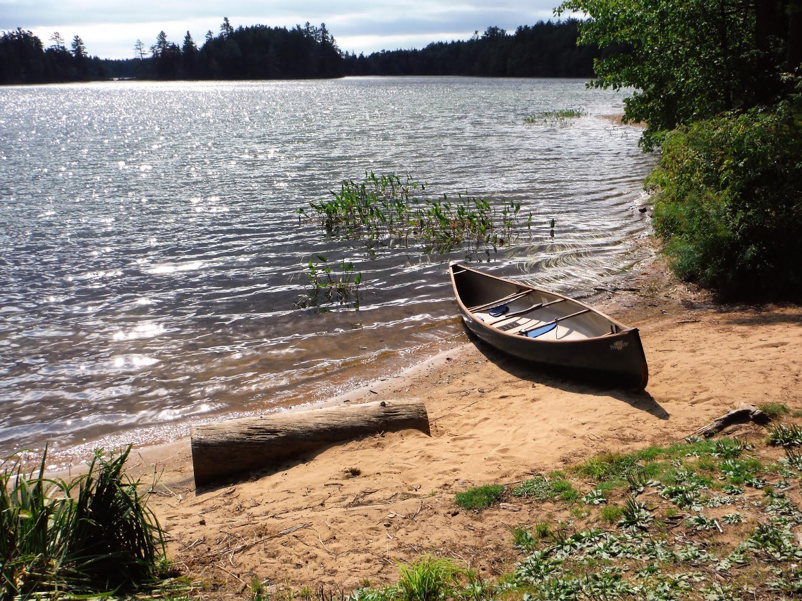
Sep 4 & 5, 2015 - Floodwood Pond to Fish Creek to Little Square Pond (camp), Whey Pond, Rollins Pond back to Floodwood. Fish Creek to Follensby Clear Pond (motorboat with trailer stopped at carry to Horseshoe Pond, so we did not).


May 11, 2014 - FLOODWOOD LOOP. Gusty wind, temp in mid-60s. Floodwood Pond, light current on Fish Creek, short carry to Follensby Clear Pond, short carry to Horseshoe Pond, short carry to Little Polliwog Pond, short carry to Polliwog Pond where we had spotted a car. Camped on Middle Pond - I've wanted to camp there for a long time but it has always been occupied, until today. Loons, turtles, mergansers, white-throated sparrows & other songbirds. No biting bugs. 4 hours. Swift Keewaydin 15, a lightweight solo canoe.


Sep 2, 2013 - POLLIWOG POND, LITTLE POLLIWOG, HORSESHOE & FOLLENSBY CLEAR PONDS. Short portages so left yoke for Keewaydin 15 back in camp. 2 loons (1 juvenile) on Little Polliwog (nice bog vegetation), 1 on Horseshoe, several on FCP (1 juvenile). Clear water. Very light mosquito activity. 3 hours. RnR in camp. Storm in evening, cleared by sunset.


Sep 1 - POLLIWOG POND. Just S of Floodwood Rd (dirt). Got nice campsite with sand beach. Loons; water smartweed.
May 6&7, 2012 - FISH CREEK LOOPS from Floodwood Rd. Floodwood Pond (camp), Fish Creek, Little Square, Copperas, Whey, Rollins, Rock Ponds. Fish Creek, Follensby Clear, Horseshoe, Little Polliwog, Polliwog, Middle, Floodwood Ponds. Mostly undeveloped, clear water, some other folks out paddling but very few camping. Mostly bad bug free - a few blackflies on land in the late afternoon - one tried to bite me in the parking area - she is dead now... Music by loons, white-throated sparrows, owls, pileated woodpeckers, spring peepers...


May 4&5, 2008 - FLOODWOOD PONDS canoe camping - short carries (100yd avg), beautiful ponds with clear waters. Put-in from Floodwood Rd, paddled short distance to campsite on Floodwood Pond (some cottages on W shore but most of pond undeveloped). After setting up camp, paddled down Fish Creek, around Little Square Pond, further down Fish Creek, into Copperas Pond, carried 0.3 miles to Whey Pond, short carry across campground road to Rollins Pond. Followed W shore to stay out of W wind. Narrow outlet leads back to Floodwood. 10 miles, 3.5+ hours. Next day: down Fish Creek all the way to Fish Creek Ponds (only part of trip where there is moderate development), up Spider Creek, into Follensby Clear Pond, short carry to Horseshoe Pond where we had lunch & soaked in some sun. Short carry to Little Polliwog Pond then carry to Polliwog Pond. Carry back to Follensby Clear, carry to Fish Creek & back upstream to break camp. 14 miles, 6+ hours. No bad bugs. Loons (& calls), marsh hawks, otter. Bell Northstar, a 16'6" lightweight tandem canoe which can be soloed.

.jpg)

Sep 18, 2006 - FLOODWOOD MOUNTAIN hike. Views from summit of Rollins Pond; Long Pond, St. Regis & Debar Mts. to the NE. From S summit open rock affords views toward Tupper Lake. Maples offered some good late summer fall foliage colors. 600' el. gain, 3 miles, 2.8 hours. EAST & WEST PINE PONDS canoeing. Start on East Pine Pond which is right next to Floodwood Rd. Short but very steep up & down carry to scenic West Pine - overlooked by Floodwood Mtn. E half is state land (a campsite is on N shore), W half belongs to Floodwood Boy Scouts. Investigated a small wood tower which unfortunately for me had a hornets nest at top - I scooted down the steps & dove into the water (good thing the camera in my pocket is waterproof) but still ended up with a dozen stings, somehow hurt my achilles tendon in the process too & going back over the carry was not easy. 3 miles, 1.5 hours.
May 8&9, 2005 - FLOODWOOD POND LOOP canoeing - just S of St. Regis Canoe Area. Floodwood area's ponds are closer together making for very short portages. Most ponds & most of Fish Creek are motor-free. Clear green water is common. Sunday - Put in on FLOODWOOD POND (some cottages on W shore but rest of pond is wild) - 15 min. to nice campsite - set up the MSR Hubba in fly-only config. Paddled down FISH CREEK (high mixed evergreen shores incl. red pine stands, some bog, small turtles). Carry to HORSESHOE POND (2 loons, grackles). Carry to POLLIWOG POND (2 loons, headwind). Short carry to FOLLENSBY CLEAR POND (broad-winged hawk) - rode tailwind S. Carry back to Fish Creek (beaver, osprey) & back to camp. 11+ miles. Mostly cloudy skies cleared, starry night. Monday - Fish Creek to LITTLE SQUARE POND. Fish Creek to COPPERAS POND (2 loons). Carry to WHEY POND (3 loons). Short carry over campground road to ROLLINS POND. Over railroad tracks into ROCK POND OUTLET (snapping turtle, marshy shores) to ROCK POND (pine shores with leafless hardwood hills, Floodwood Mt. to W). Back to Rollins then take outlet (narrows into a rocky 4' wide mini rapid) into Floodwood Pond. 13+ miles. Sunny, warm (70F) day brought out some blackflies but they weren't too hungry yet. Merrimack Baboosic, a 14' solo canoe. Strapped my 2 paddles (a Foxworks Foxtail & a Mitchell) to thwarts to make a yoke.

May 10-12, 2003 - FLOODWOOD Rd AREA & St. REGIS CANOE AREA canoeing. Floodwood (camp 1st night), Fish Creek, Little Square (osprey & nest), Spider Creek, Follensby Clear, short carry to Horseshoe, short carry to Little Polliwog, short carry to Polliwog (camp 2nd night), walk to Middle, longer carry with muddy sections to Hoel, thru a culvert with 1' drop into Turtle, Slang, short carry to Long, hike to Mountain Ponds in NW Adks. Owls & loons a-hootin'n'a-wailin'. Flowering: leatherleaf, red trillium, yellow violet, trout lily. A few blackflies but no need for bug protection yet - will be bad in a week or 2 - they like temperatures in the 60s & 70s. Some rain the last half of trip but we had the tarps up before it started & the last day's drizzle actually added a pleasant softness to the surroundings & we still enjoyed the day absorbing the negative ions & piney scents. Took a swim in Polliwog on the way out - not too bad, could stay in the water a few minutes in shallow sandy area. Saw a few other canoes & kayaks S of Floodwood Rd Sat/Sun but we had Hoel, Turtle, Slang & Long Ponds to ourselves on Monday. Would avoid Square & Fish Creek Ponds in summer due to PWCs & motorboats. Bell Merlin II , a 15' solo canoe, is just about the perfect Adirondack canoe, great at everything. Experimented with methods of doing Adirondack carries with a kayak - had 4 canoes (all Bells - "The Bell's Angels" - 2 Merlin IIs, a Magic, a Northstar paddled solo) & 13.5' Swift Tasman Sea Exp kayak in the group - canoes are still the best way to go in this environment but with so many people buying kayaks these days we've got to work out some systems that work. A Bell solo portage yoke worked well with the stern to the front & all gear must be carried seperately in a backpack (this necessitates that you have to empty & reload the kayak on each end of the carry) like the SealLine Boundary 70 or 115. Sleeping bags & clothing would do best in something like SealLine Black Canyon Compression Dry Bags. The Tasman Sea & many other composite kayaks have cockpit coamings which are easy to attach a yoke to - the coaming on plastic kayaks may not be so easy (in general, you don't buy plastic kayaks to do portages with, mainly because of their heavier weight). Some carry trails are smooth enough for wheels, some are not + wheels are extra weight.
Oct. 7 & 8, 2001 - Grabbed a drive-in campsite off the Floodwood Rd. (NE of Tupper Lake) with a nice beach on Polliwog Pond. Still pretty good fall colors but area does not have a lot of maples. Brisk west wind, temp. in the 40's - we weren't sure whether we should paddle. Took the canoes out onto Polliwog Pond & stayed to the west shore to avoid the wind. Warmed up by the paddling. Carried over to boggy Little Polliwog Pond & then carried to Horseshoe Pond. Couple of loons here & 2 campsites were taken with small outboard motorboaters who had 1 short carry to get them in. Carried over to Follensby Clear Pond & paddled around a couple of islands to the SW. See 1 loon. About every hour the wind would pick up & bring a snow squall but after 10 min. the sun usually came out. The squall on Follensby Clear was especially brutal, the icy snow blasting our faces, we hit shore for a break. Paddled to the N of FCP. 2 loons were not too perturbed by are presence. The carry back over to Polliwog is a bit longer but still only takes a couple of minutes. A very interesting 3.5 hr. trip. Set up the tarp leanto-style with low end cutting the wind. We had brought huge quantities of firewood & spent most of the rest of the day huddled near the fire. Skies cleared for a while after dark & I admired the stars. As in most recent trips, I paddled the Bell Merlin II, my favored solo canoe. Exra warm clothing is essential this time of year - avoid anything made of cotton (does not insulate when wet). While paddling Nehasane wore: wool socks, Sealskinz waterproof socks, Chota neoprene mukluks, hydrowear pants, Palm waterproof paddling pants, wicking long sleeve undershirt, nylon shirt, thin fleece sweater, waterproof/breathable shell jacket, wool gloves, earband, OR Seattle Sombrero + had extra dry, warm clothing in a dry bag (SealLine Day Pack) & Grabber Hand Warmers.
Woke to more snow showers & an inch of the white stuff on the ground. Temp. did not drop much below freezing, tho. Warmed by a morning fire, most of the gang didn't have the desire to do more canoeing. We drove to the Visitor Center in Paul Smiths. After taking in the displays on history, geology & the natural environment we took a walk on the recently-constructed 1.1 mi. Boreal Life Trail. After reaching Barnum Pond, a 1600' boardwalk took us over a bog & it was interesting being able take an up-close look. After a hearty mid-afternoon lunch in Ray Brook there was still plenty of daylight for a short hike. More sunny now so climbed Owl's Head, E of Lake Placid. 460' quickly gained in a little over half a mile. Views in all directions. Surrounded by Pitchoff, Cascade, Porter, Giant, Hurricane Mountains. Colors just past peak. Trail is interesting in that there are many red pines & red oaks along the way. Oaks are not too common in the Adirondacks, being more of a low land species. There is some evidence of forest fire.
May 13/14, 2001 - Floodwood Pond, Fish Creek, Follensby Clear, Horseshoe (camp), Polliwog & Middle Ponds loop. Merrimack Baboosic, 14' solo canoe, symmetrical hull with some rocker, nice freestyle boat (Merrimack has gone out of business.) Minimal bad bugs. Put-in on Floodwood Pond (just before railroad tracks on Floodwood Rd., a good dirt road, north of Tupper Lake, west of Upper Saranac Lake.) Soon hear the call of the loon as an osprey circles overhead. Pass many excellent campsites on this trip. A few camps & the railroad on west shore, rest of trip is undeveloped. Exit on Fish Creek which is about 20' feet wide. See lots of fish. I go slowly; slight current helps move me along. Using a Mitchell paddle which goes zzzzzuppp on recovery of Canadian stroke just like Bill Mason says a paddle should (buy any video by him esp. Path of the Paddle-Quietwater & Waterwalker.) Creek opens up with Little Square Pond on right. I go half way down & return. See 2 ospreys & nest in top of dead pine overhanging the pond. (Ospreys nest are always at top of trees; great blue heron nests are often below actual top of tree). Fish Creek now 100' wide sometimes with steep evergreen shores, sometimes boggy. Thought about continuing thru Fish Creek Ponds (not recommended in summer due to increased motorboat & jet-ski traffic) but carried directly over to Follensby Clear Pond (easy 200 yd. carry.) FCP has beautiful clear water & distant mountain views. Followed west shore to short carry to Horseshoe Pond. Nice campsite with sandy beach at end of carry. Fireplace was still smoking - poured some water over it (please make sure your fire is totally out when breaking camp.) Also found 2 bars of soap someone had left behind - why do people need to be so clean? Had my mind set on the campsite on the point (inside of the horseshoe) & a nice one it is. Set up tarp, sleeping bag & an Outdoor Research bivy. Sunny, high 50s. Late afternoon, paddle to south & take walk (cross one snowmobile trail & short bushwhack to snowmobile trail which parallels Fish Creek.) Walk NW for half hour - creek is not visible a lot of the time. Purple trillium along the way. End up at campsite opposite Little Square Pond. Blueberry bushes flowering. Distant loon wail. Hermit thrushes in surroundsound on the return. Get up before sunrise - mist on the pond - thrushes are at it again. Sunrise filters thru the mist - big splash! - see osprey pull fish out of the water. A loon calls from a nearby pond. 35 degrees, need hat & gloves. Break camp; short carry over to boggy Little Polliwog Pond. Carry over to Polliwog Pond, see another osprey. Polliwog is very attractive & has easy access from Floodwood Rd.) 0.5 mile flat carry over to Middle Pond; Floodwood Rd. is close. See empty osprey nest & 2 loons. Carry to Floodwood Pond is a bit steep so I park the Baboosic & walk the road 1.2 miles back to the car. Surprised to see as many ospreys as I did but saw fewer loons than last time I passed thru. All gear fit in my Sealline Propack. Luxury on this trip was deluxe knee pad which I don't often bring when there are carries involved.


Comments
Post a Comment