JOHN & CLEAR PONDS hiking, skiing, camping in the Adirondack Park
Southeast of Indian Lake village.
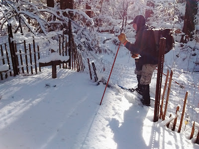
Jan 9, 2020. JOHN & CLEAR PONDS ski. Siamese Ponds Wilderness. Temp at start 10F rising to 20F, blue skies, no wind. Very good skiing on a solid base (~6") topped with 3"-7" of powder (more in open areas & hardwoods, less in the softwoods which still held snow on the branches). Fairly easy skiing to JP. Someone had skied the first mile - easy breaking trail after that - I broke the whole way despite having 4 others who could help. Some wetness below the powder on the ponds (the prepared skier always brings a scraper). Lunch on JP in the sun, felt warm, quick stop at the lean-to. Intermediate skiing to CP with some short steep downhills on return. Some blowdown. Back the same route. 8.2 miles, 4.7 hours. Doing the loop would have been shorter but we wanted more skiing.
In the Adirondack Park, there are 43 Mud Ponds, 21 Long Ponds, 16 Clear Ponds, 16 Round Ponds, 14 Lost Ponds, 14 Rock Ponds, 14 Deer Ponds, 13 Grass Ponds, 12 Buck Ponds, 10 Lily Pad Ponds & 10 Bear Ponds.
JOHN & CLEAR PONDS skiing. Siamese Ponds Wilderness from S end of Wilderness Lane (1,700'). ~2' of snow. Feb 3, 2019 - novice rolling terrain to John Pond (1,870'), broken out - excellent skiing. Set up camp in the lean-to in tall red pines. A rocky ridge rises 500' up from the W shore - adds a dramatic backdrop to the scene. Broke trail on the new trail to Clear Pond (1,900') - there are several short steep ascents making this section intermediate, tops out at 2,000' before dropping gradually to the pond 1.1 miles from junction. Returned to JP in my tracks, downhills were fun. Temp 25-35F - started to get a bit sticky so I stopped to apply some Maxiglide. Stayed above freezing overnight. Feb 4 - did the whole JP-CP loop (yellow markers) counterclockwise with the spur trails to each pond + the grave site (red markers)+ some exploration - most had been broken out. There is a new section with yellow ski markers that links the CP trail with the JP trail not far from Wilderness Lane - no longer necessary to walk the road between trailheads. Temp in lower 40s, very good skiing. 5.5 miles. Coyotes howled at dusk. Stayed above freezing overnight, rained a little. Feb 5 - Still very good skiing on the way out. Deer.
Oct 2017 - JOHN POND from Wilderness Lane. Siamese Ponds Wilderness Area. Vehicles with fair clearance can drive the 0.1 miles to register. Backpacked 2.2 miles to JP in <1 hour. My 1990 edition of Discover the South Central Adirondacks says: "A walk along this road can be depressing." But vehicles have stopped driving it and nature has taken over slowly but nicely. Along the way there are views of Bullhead Mtn, John Pond Brook and a spur to 2 graves of youths who died of black diptheria in the late 1800s. The route gets pinier as one goes. The lean-to is situated amongst red pines & balsams. A well-patched camo canoe sat by the water + 2 oars - being the purist, I used 1 oar and paddled around. Later, I succumbed & rowed it using both oars. The pond is only 0.3 miles long. A cliffy ridge rises 500' up from the W shore, Bullhead dominates to the E. Mostly quiet & peaceful. The logbook at the lean-to goes back to 12/28/2010. Very good fall foliage, lots of maples. Pileated woodpeckers, gb heron, turkey vulture, newts; barred owls called at night. Still some stable flies around. JOHN POND RIDGE bushwhack, from John Pond. Crossed the outlet, headed up sort of W. From southerly bump, dropped down a bit then up steeply to the middle bump where there is the best view W. Then on to the 3rd bump, views keep changing from one ledge to the other. Many views in all directions - sort of like the Nundagao Ridge for whackers. Awesome! 2.1 miles, 2.8 hours. JOHN & CLEAR PONDS LOOP TRAIL from the JP lean-to. There is a new 1.3 mile trail that connects the 2 ponds - one can do a loop using a 0.15 miles walk between trailheads on Wilderness Lane. The loop is now marked with yellow markers & the 2 short spurs to the ponds are marked with red. The trail to JP is easy. From 0.1 mile before JP the new trail travels well E of JP on rolling terrain reaching CP's S shore in 1.1 miles then parallels the SW shore to the spur. The latter goes across the outlet & a nice rocky area. From CP to Wilderness Lane the trail drops 200' in about a mile. Lovely fall foliage. 5.4 miles. For skiing purposes - WL to JP easy, would need only ~5" of snow to make it skiable; from JP to CP intermediate, probably needs a bit more; CP to WL intermediate but is rocky so would need well over 1'.


Comments
Post a Comment