OK SLIP FALLS & ROSS, WHORTLEBERRY, & BIG BAD LUCK PONDS skiing, hiking.

The Hudson Gorge Wilderness not only contains the most exciting stretch of the Hudson River, but also one of the highest waterfalls in New York State, plus several seldom-visited ponds, as well as a few small, trail-less mountains with views. The trails to the falls and three of the ponds can be skied by strong intermediate skiers when there is over a foot of snow on the ground – they can also be snowshoed by just about anyone in half-way decent shape.
A trip to the falls and all three ponds would amount to close to 15 miles of travel, so most folks opt to go to either the falls or the ponds – the trip to OK Slip Falls has become very popular, but the ponds see less visitation, especially in winter. The trailhead and the first half mile is the same for either trip – so when you get to the fork in the trail, would you take the trail less-traveled and go for a little bit of Bad Luck? Or slip and slide over to the more than just OK attraction?
The parking area is located on the south side of NY Route 28, half-way between North Creek and Indian Lake. One has to walk west alongside the road for 0.2 miles to reach the actual trailhead. The trail passes through conifers at first then mixed woods of sugar maple, beech, spruce, hemlock, and some large white pines. After a bit of a climb, the trail reaches a junction at the 0.7-mile mark – a right turn heads toward the falls and the route straight ahead leads to the ponds.
Ross, Whortleberry and Big Bad Luck Ponds
From the junction, the route is mostly downhill then it crosses Bell Mountain Brook. The trail then climbs over 200 feet in 0.4 miles going over a shoulder of Bell Mountain before leveling out somewhat. Some beaver meadows can be seen to the north before reaching a junction, 2.2 miles from the start – a right turn puts you on the short trail to the south side of Ross Pond but I usually just ski down through tall evergreen woods to the pond's west shore. My notes from last winter describe the pond as “cute, with a couple of small islands”.
Back on the main trail, now mainly going downhill, another junction is soon reached – a left turn reaches Big Bad Luck Pond in 0.5 miles. Going straight and continuing downhill, the trail to Whortleberry Pond is not marked as well as the others in the area so some added attention to the route may be necessary. If I had to skip one of the ponds, this would be the one. However, curiosity has won out every time I've been out this way.

The spur trail to Big Bad Luck Pond is well-marked and a pleasure to ski. The trail ends at the outlet on the east end of the large pond. If the ice is solid, which is likely in mid-winter, one can ski across to the campsite on the north shore – as you ski out onto the pond, look down the pond for a view of Snowy Mountain. The return trip will have a couple of exciting downhill runs. If you visit all three ponds, you will have traveled at least 8 miles, more if you skied out onto the ponds.


OK Slip Falls
From the junction, the trail to the falls heads northeast over rolling terrain through a mature forest. A beaver pond is passed and the trail then goes through an area that was logged more recently so the trees are smaller. A woods road which gives access to the private Northern Frontier Camp, is reached after traveling over 2 miles from the NY Route 28 trailhead. The trail follows this road for less than 100 yards then turns off it to the right.

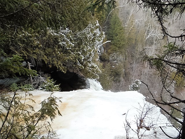
The grade is then gently downhill at first but steepens as the trail gets closer to the top of the falls and hardwoods transition into a forest of large hemlocks and white pines. Switchbacks ease the grade to a certain extent but good ski control is needed on the descent. At a junction, the way right leads to views of the top of the falls – the combination of water and ice can be breathtaking. Be very careful if there is any iciness since the drop over the cliff is well over 200 feet.


At this last junction, the trail left soon drops steeply to cross OK Slip Brook on a bridge then goes up a short steep stretch before leveling out for a bit. The trail then drops steeply, losing well over 300 feet, via switchbacks down to the Hudson River. I have fantasized about skiing this 0.8-mile trail but have only hiked it in late winter with little or no snow on the ground (March 21, 2016 was a low-snow winter). In reality, I cannot recommend this section to most skiers, but do go for it if you are on snowshoes. At the end of the trail, Kettle Mountain looms over the river on the opposite shore. I have skied up Kettle, a bushwhack from Northwoods Club Road, and viewed the falls from above and across the river.


Round-trip to and from the top of the falls is over 6 miles and close to 8 miles if you go down to the river.
Whichever route you travel, you will be sure to leave civilization well behind. Make sure you carry the “10 essentials”, and more, for a safe and pleasurable trip. Check the DEC website at https://www.dec.ny.gov/outdoor/7865.html for updates and recommendations before you head out.

1/21/21 - OK SLIP FALLS, Hudson Gorge Wilderness - 2" fresh powder in broken-out trail, avg 15" depth, mostly powder - an occasional rock exposed & some wet brooklets to step across, otherwise excellent conditions, snowed all the time we were out. Some sweet curvy downhill runs. The waterfall was ok - ice broke off crashingly a couple of times. 6.8 miles (incl. 0.4 on side of road), 4.8 hours. Saw 2 snowshoers. No tracks going toward Ross, Whortleberry, & Big Bad Luck Ponds.


2020 - ROSS, WHORTLEBERRY & BIG BAD LUCK PONDS ski. Hudson Gorge Wilderness Area. Still 15-20" dense snow, temp 40-55F, it did not go below freezing overnight so it was not very icy & even softer as the day wore on. Ross is cute with a couple of small islands, Whortleberry not too interesting & the trail is poor & hard to follow, Big Bad is scenic - there was water on the surface of ponds so we only skied raised edges. Skiing is on the harder side of intermediate with plenty of hills on narrow twisty trails, some blowdown & exposed rocks. 8 miles, 5.4 hours.
Mar 21, 2016 - OK SLIP FALLS & HUDSON RIVER hike. Hudson Gorge Wilderness. Nice scenic walk thru the new section of trail passing some meadows en route. Can't see the bottom of the falls 200' below from the 2 most common view spots. The trail to the river from the falls viewpoint soon crosses OK Slip Brook near the top of falls on a wood footbridge - the trail is very steep & was icy on either side of the brook. The trail stays high & fairly level for a while before starting to drop steeply to the river - lots of switchbacks help ease the grade - loss of 400' in less than a mile from the falls viewpoint. Can not see the falls which is well upstream from the junction of the Hudson & OK Slip Brook. Kettle Mountain rises up on the other side of the river - have skied to Kettle where there is a very good view of the falls. No snow. 8.2 miles, 6 hours.
Mar 17, 2008 - ROSS, BIG BAD LUCK & WHORTLEBERRY PONDS. Hudson River Gorge Primitive Area. Deep hard base; lousy (shaded areas icy) to good (sun-softened areas & out on ponds) skiing; without new snow best skiing will be when temp is above 40F. Some blowdown; stream crossings ok. The trail seemed like it was rarely flat, fairly steep up to the notch. Quick icy drop/slide to Ross; tight, narrow trail thru evergreens to BBLP (view of Snowy Mtn, some ATV & snowmobile tracks); tight, narrow drop to WP. Each pond has a totally different character. Explored WP Outlet a short distance - area downstream should be added to the Forest Preserve in near future, hopefully giving access to OK Slip Falls. Otter tracks. Intermediate+ in good conditions, advanced today. 9 miles, 5.7 hrs.
Apr 7, 2014 - OK SLIP FALLS. From Rt.28 in North River, parked on the shoulder. Unplowed dirt road accessing Northern Frontier Camp had snowmobile use - rolling hills. After 30 minutes turned R on 1 mile marked trail to falls, the trail had seen some recent ski & snowshoe use (intermediate skiing). Took skis off & walked a short steep section to 2 good but icy lookouts - what we could see of the falls was real nice with ice & water. The falls drop 250' down into the Hudson River Gorge (a 0.8-mile trail leads down to the river). Continued up the road to the camp's gate. Skiing good to very good - no iciness, untracked snow was becoming unconsolidated in the pm, temp ~50F. 4 hours.


Comments
Post a Comment