Feb 2, 2025 - NATURE TRAILS ski by the LG Elementary School. Red trail (low intermediate, I went clockwise) had a fair amount of foot traffic, just 1 set of snowshoe tracks on Blue (easy,), light foot traffic on Yellow (intermediate, counterclockwise). Up to 6" mostly powder, thin under hemlocks in a couple of spots, good skiing. Temp in the mid-teens (it was -6°F in early morning), cloudy. Saw 1 person with 2 dogs (note: pets are not allowed). Also hit the Bikeway & Battlefield Park. 3 hours.
July 25, 2024 - SHINGLE EAST hike. Started on Big Hollow Rd (4WD trail, some new gravel/rock in places) - power company is doing work in the area, so 3 heavy work vehicles were parked. Climbed with switchbacks on a mtb trail & crossed the white trail. Small views thru the oaks. Looped down on white trail & bushwhack. 3 miles, 1020' el gain, 3.4 hours.
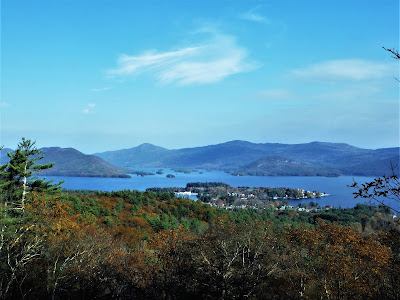
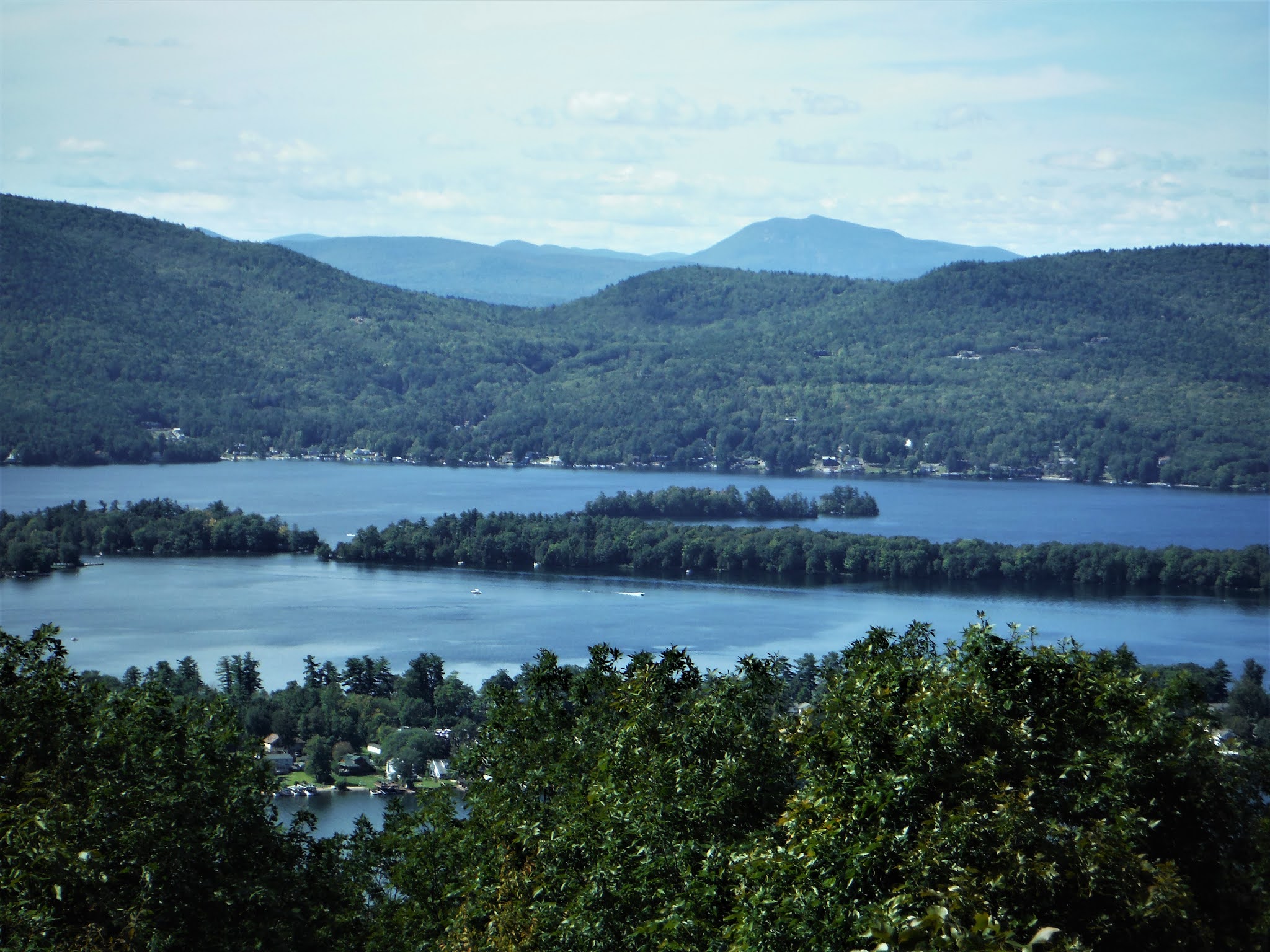
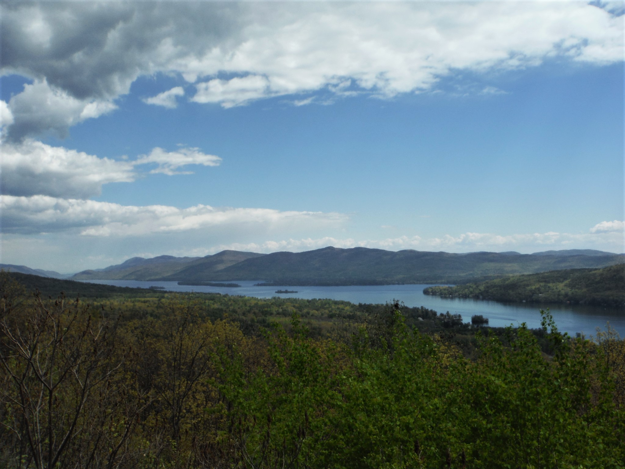
July 13, 2024 - RATTLESNAKE COBBLE hike, from the village. Warm & humid - upper 70s, partly sunny (forecast said "cloudy"), a light breeze. Part trails, part off-trail. Uphill start & did not take long for sweat to pour into my eyes. Light mosquito activity - no bug dope used although clothes had been treated with permethrin. Mushrooming starting to get more interesting. Going downhill was nice. 2.7 miles, 840' el gain, 2.7 hours (2 hours moving time).
April 17, 2024 - Short hike to a lookout in the northern section of LUZERNE CAMPGROUND & DAY USE AREA, from Dunkley Rd (dirt). The trails are shown on OpenStreetMap & newer (2020) NatGeo #743 (not my 2004 version). The trail heads N from the road (730' el) on an old road with horse trail markers. At 0.1 miles, the trail turns R & looks more trailish than old road. Moderate climb thru pleasant woods. Reached the summit of the hill (1090' el) at 0.5 miles. The trail then heads E then S, dropping 140' to the lookout. The view to the S over a widening of the brook that runs into Fourth Lake to Bucktail Mtn (1824'). Could see Darling Mtn to the E & the cut thru the low mountains where the Hudson River passes to the SW. Not much civilization in view other than the Painted Pony ranch, but Route 9N traffic can be heard below. Back down to the old woods road & headed N to the edge of state land & beyond - curious whether this led to the Harris Preserve. Out of state land, there was a long section of wetness, then spotted a path to the L, then soon reached a posted gate 0.3 miles from the trail junction. Back a bit & checked out the unmarked path which did in fact reach the Nature Trail of Harris Preserve after 0.2 miles. Back to start. 2.4 miles, 640' el gain, 1.6 hours. Thanks to Jeff for suggesting this hike. I combined this short hike with a 20+-mile road bike ride in the area.


April 16, 2024 - BIG HOLLOW BRANCH & SHINGLE EAST hike. Lots of rain last week - had to get out to see my favorite waterfalls. Mostly bushwhack along the brook - slow going, tough at times. Looped on an unofficial trail up a small peak for views - lots of leafless oaks made for better sights. Some early blackflies enjoyed attacking eyes & nostrils. Too early for wildflowers & interesting shrooms in the Adks. Mostly sunny, temp rising into the low 60s. 6.5 miles, 1300' el gain, 4.6 hours.
March 24, 2024 - BATTLEFIELD PARK to SCHOOL NATURE TRAILS ski, via the Bikeway. Hard work breaking trail today on up to 18" - skis sunk in 10". I picked up some ice on skis & did not realize it for way too long, made it harder. Broke out a loop in the natural area & went around 4x - got better each time. Better going back in my tracks. Temp in the low to mid-30s, sunny. 4.2 miles, 2.6 hours.
March 23, 2024 - BATTLEFIELD SP ski.
Up to a foot of new snow by the time I got out on the skis (mostly at the park) - it was tough breaking trail, so I kept on going in a big oval route so I could ski in my tracks (in both directions) - just kept getting better the more I went around. Temp in the mid-20s, still snowing. Temp in the mid-20s. 5.1 miles, 340' el gain, 2.5 hours. My 40th ski of the season.
March 19, 2024 - An end-of-winter hike. I went out thinking that I would start out along one brook then loop back ending on another brook (WEST BROOK) - I had not thought about how I would make the connection let alone that I would end up bushwhacking steeply up an unnamed hill that showed much evidence of past logging. Mostly cloudy, some sun early & late, temp rising thru the 30s. 4.7 miles, 890' el gain, 3.6 hours.
March (felt like April) 4, 2024 - WEST BROOK waterfall hike. From near the ballfields at the LGRC. Short bushwhack down to the lower series of falls. Then on trails within the LGRC. Off-trail from Magua's Revenge upstream. A few patches of ice & snow. Temp in the low 50s, cloudy (a good thing when you want to photograph waterfalls). Trails & off-trail, looped back up on an (new-to-me) old skid road & down on an old woods (familiar) road. Elevations ranged from 510' to 1270'. 4.1 miles, 787' el gain/loss, 2.9 hours.
Dec 20, 2023 - SHINGLE EAST & BIG HOLLOW BRANCH loop hike. It had rained a lot 2-3 days ago. From the tunnel under the Northway, whacked uphill, found a path & lost it twice. White disc trail to the top then down, crossed the 4WD trail & whacked downstream along the brook. 3+ miles, 1099' el gain, 3.2 hours.
Nov 30, 2023 - RATTLESNAKE COBBLE hike. Up to 2" of crunchy snow - the spikes stayed in the pack bur as usual trekking poles were helpful. 800' el gain, 1.8 hours.
Nov 20, 2023 - WIAWAKA UPLANDS hike on the northern part of the French Mtn range. The trail starts behind an old storage building. Short loop on the red trail then up on the yellow trail to the lookout (~510' el) which has views of motels & Prospect Mtn area. Saw a bunch of turkeys. 1.5 mile, 260' el gain, 1 hour. Mapped it so I can tell how this area relates to the McPillips Preserve to the south.
Note from June 2024: the driveway for the below FRENCH MTN hike is chained off with a no tresspassing sign:
Nov 15, 2023 - FRENCH MOUNTAIN RANGE hike, from Bloody Pond Rd. I call it a range because there are many small summits in here, not just 1 peak (the actual summit is at 1513'). 12:20 pm start, 2:15 pm turnaround time. Wanted to see if the towns had done anything new yet, like mark & clear trails - no; & see what I could find whacking to the N. From the parking area, go uphill to the E to an old woods road & take a L. At 0.2 miles bear R, & R again at 0.3 miles. Go straight after that. At 1.1 miles take a L to drop down to the lookout at 1.2 miles. Got to the main lookout in 50 mins, then bushwhacked N & E to see if I could find any other views, with some success. Lots more old logging roads in here to explore & no posted signs. Temp in the low 40s. 4.4 miles, 1234' el gain, 3.3 hours.
Basic Map.
Nov 14, 2023 - BIG HOLLOW. A somewhat serendipitous hike today. The forecast was cloudy in the am, some sun in the pm, so I started at noon, set a turn-around time of 2 pm, and got done 20 minutes before sunset. The usual mix of trails & whacking, plus some pavement since the Prospect parkway is now closed to public vehicles. I told myself that crossing the big brook could be slippery (icy rocks), so I slip & get some water in my boots, but merino wool socks felt warm so continued on - hope my boots dry out so I can hike tomorrow. 8 miles, 1500' el gain, 4.2 hours.
Nov 8, 2023 - "SHINGLE EAST" - more exploration of the unofficial white disc trail. Sort of like looking for the gold at the end of the rainbow, or just satisfying my curiosity. Started at 8:15 am so had plenty of time to poke around. Did a loop using secret trail, official trail, old woods road, & the white disc trail. here were several small views along the way. Lost the WD trail at its NE end in blowdown on a steep side of the mountain, refound it for a short distance, then could not find more white discs but found other markings at the corner of state land (see pics). Temp rising thru the 30s, breezy. 5.2 hours. There is an 885.5acre easement (Upper Hudson Woodlands) N of Shingle East but it is not easy finding info on it.
Oct 28, 2023 - RATTLESNAKE COBBLE hike.
Oct 15, 2023 - NATURE TRAILS & EAST BROOK PRESERVE. 2-hour walk in adjacent lowland preserves. Just to get some exercise, check out the mushrooming, & enjoy autumn nature. Honey mushrooms & puffballs. Deer. Temp in the mid-50s. 3.5 miles.
Oct 10, 2023 - Waterfall hike, bushwhacking along Big Hollow Branch. Then climbed up for some views & some more exploration of the unofficial white trail. 4.5 miles, 1014' el gain, 3.9 hours.
Oct 2, 2023 - PROSPECT & BLACK SPRUCE MOUNTAINS hike. Prospect by marked trail (on top by 9am, a bit hazy but could still see the High Peaks), then BSM (2349' el) & loop back by bushwhack & old woods roads. Fall foliage was quite a bit more advanced above 1500'. 8.5 miles, 2280' el gain, 6 hours.
Sep 14, 2023 - Low humidity (for a change) & temp rising thru the 50s & 60s - nice hiking weather. Did a combination of old woods roads, bushwhacking, & marked trails. Hit the narrows lookout, Noosa's Bluff, West Brook, & more. Brought home some lobster mushrooms. 5.4 hours.
Sep 12, 2023 - EAST BROOK PRESERVE from Bloody Pond Rd. There is now a kiosk near the road & some educational info stations but no info yet.
Aug 31 - SHINGLE MOUNTAIN hike. Great hiking weather - mostly sunny, 60s, low humidity. Decided to explore a small mountain I've been eyeing on the map & from nearby locations. Started out bushwhacking, picked up an unmarked path, climbed to an unofficial trail with some views, bushwhacked up to the goal (got more open higher up). No views from the glade-like summit area. Whacked steeply downhill to a trail & looped back to start. Found some chicken of the woods. Very light mosquito activity - I did not feel the need for protection. Saw no one. ~6 miles, 1673' gross el gain, 4.5 hours. Heat & humidity comes back for the holiday weekend.
Aug 9, 2023 - BIG HOLLOW BRANCH & SHINGLE EAST hike. Lots of rain lately - good for a waterfall & shroom hike - loop mostly off-trail, some unofficial white trail, & some herdpath. Enough water to make the waterfalls interesting, but not so much that I could not find a place to cross the brook when advantageous. Up high, heard some clicking sounds & thought they were crickets but soon found out that they were made by juncos. I had found this unofficial white trail before but did not follow it down to the E so did that this time, it started going in the wrong direction (NE) so I picked up a herdpath going ESE & ended with a whack & came out near the start where a ranger vehicle happened to be parked. Temp rising thru the 70s. Some mosquitoes & those swarming gnats that think they are blackflies. 5.2 miles, 1165' el, 3.5 hours.
June 11, 2023 - NATURE TRAILS & EAST BROOK PRESERVE. Walked most of the nature trails. Noticed some flagging going E of the red trail. A new 0.25-mile trail leads from the easternmost part of the red trail to Bloody Pond Rd (comes out just N of the French Mtn trailhead), & crosses East Brook on a good bridge. Also some new boardwalk & rock steps. Not too buggy. 2.9 miles, 1.3 hours.
June 5, 2023 - FRENCH MOUNTAIN from Bloody Pond Rd. A short dirt/gravel road leads to the parking area. A narrow path soon leads to an old woods road & I headed NE. At junctions, the best advice for the time being is to stay on the woods road that is less overgrown. The route turns S of E before slowly bending to the N, alternating between moderate & steep sections. After about 1.1 miles look for red flagging to your L which leads to the lookout (you can also stay on the road a bit further & find a good route). Arrived at the lookout (1300' el) after gaining 830' in 1.2 miles, it took me 50 minutes - no bad bugs so far. LG village is down below. L to R, there are views to West, Darling, Potash, Hadley, Black Spruce, & Prospect Mtns. I wanted to continue on the woods road to see where it goes - I would take it until I saw posted signs. It started to curve to the E & there were a couple of puddles & dried mud - mosquitoes started to attack - I sprayed some bug dope on my bare arms & neck. Took a spur to the L & found a tree stand. On another spur L there was a cabin (still no posted signs). Turned around after going 1.2 miles (still no posted signs) past the lookout. Back near the lookout, I whacked up to the actual summit (1513' el) which is wooded. There are some limited views SW of the summit. Back down on the woods road. Saw some violets & bluets. Found tiny wild strawberries at the trailhead - ripe but so small that it was hard to be able to gorge on them. Temp rising thru the 60s. 5.1 miles, 1329' gross el, 4 hours. The route to the lookout is shown on OpenStreetMap.
June 4, 2023 - RATTLESNAKE COBBLE (1,211' el) on & off-trail hike. Very light black fly activity, temp ~60 & windy. Lots of cobwebs near the ground. Pink lady slippers. Very dry. 2.4 hours.
May 16, 2023 - LAKE GEORGE RECREATION CENTER. Short hike with WILDFLOWERS & WATERFALLS. Saw bluets, violets, fringed polygala, foamflowers, & starflowers. Light black fly activity on the hike, more in the parking lot (they are learning that people tend to drop their guard & are easier prey when near their cars). Saw my first mosquito of the season. Temp rising thru the 60s - the forecast was sunny but got hazy sun with high clouds or smoke from wildfires in western Canada (good for plant & brook photography tho). 2.2 hours.
Expecting temps to drop below freezing in the Adirondacks early Thursday, May 18 (hopefully, that will kill off some of the black flies).
Feb 23 - NATURE TRAILS ski from LG Elementary School. Very good skiing on 5" of new snow. In the am, there was a very light mist/drizzle which left a hint of crust in open areas but no issues in the woods. Broke out the red & yellow trails - skied the red twice, plus yoyoed a bit on both. Saw 2 other solo skiers as I was finishing up. Saw a deer watching me.
Feb 15 - NATURE TRAILS & EAST BROOK PRESERVE ski, from Old Military Rd. Temp in the 50s (a record high of 59 for Glens Falls). Somewhat icy on groomed (not recently) trails. Better skiing on up to 6" of dense snow off-trail - explored the area around East Brook & tributaries. 1.5 hours.
Feb 13 - LG BATTLEFIELD STATE PARK ski. Temp rising into the mid-40s. Up to 5" of dense snow, soft in sunny areas, still crusty in the shade. Spent an hour yoyoing up & down the sunny hill - excellent turns practice, very enjoyable. Skied up the Bikeway a little - variable conditions.
Feb 3 - it was 0 degrees at 8am & expected to continue dropping throughout the day.
Feb 2 - I needed some exercise before entering torpor in the igloo - was out on the snomo trails (fast) today with a little off-trail (fair skiing on the flats in hardwoods), around Stannard Pond, & checking out an old woods road (poor crusty skiing in softwoods, someone had skied it over a week ago & also did some trail clearing with a saw - I had a fun ski down last winter). 2.2 hours. My 18th day of skiing this season.
Jan 8, 2023 - "HILL 1416" hike. Started on the red Prospect Mtn trail, L on the toll road to Stannard Pond, R on an old woods road to the junction with the unmarked southern trail to Prospect. From there, I bushwhacked SE dropping down a bit before climbing thru open woods. Lots of rocks (looks like good rattler habitat) & oaks near the 1416' summit. Views were mostly filtered thru leafless trees. Zigged down steeply to the SW then zagged SE - found more rocky areas with limited views. Hit an old logging road that went SE but I soon left it so I could loop back to the toll road going around the rocky E side of the hill. 6 miles, 1565' el gain, 4.2 hours.
Jan 7, 2023 - WEST BROOK hike. Followed it upstream, often off-trail, to 1,220' el then crossed the brook on some mossy rocks. Climbed out of the ravine, crossed a logging road with much deadfall, then soon after hit the old woods road I was more familiar with & took that back down. Crossed the brook on the bridge & followed another old woods road east. Stayed well above the brook (on the south side of "hill 1416") & then the road ended (or I lost it). Whacked down to start. 4 miles, 850' el gain, 2,7 hours. Mostly snow/ice-free, did not need spikes, not much mud either.
Dec 19 - BIG HOLLOW ski. Carried skis up the Prospect Mtn red trail to the toll road which was groomed for snowmobiles but they are not allowed yet - good for me. Skied that up to where the white trail crosses (1,400' el) & headed off on an old woods road. Crossed a small brook but did not like the looks of crossing Big Hollow Branch so bushwhacked up the side of it up to Big Hollow. Had lunch at the old reservoir (remains of the dam still there), now a small beaver pond. Skied a bit on groomed snomo trail west then returned. Dropped 200' in 0.5 miles on an old woods road with a steep drop-off down to GHB, lost the road in some hardwoods then refound it. Back onto the toll road a bit above the Eagles Eye viewpoint. 12"-16" of snow above 1,000' el. 8.7 miles, 1,249' el, 6+ hours.
Dec 4, 2022 - A short loop hike to 2 lookouts on Prospect Mtn. Much off-trail (dry), some pavement & streamlike red DEC trail. 1.6 hours.
Nov 16 - BATTLEFIELD STATE PARK skiing. Good skiing on 3" (may have been 4" if I had gotten out 2 hours earlier) in the open areas - less under hemlocks & pines plus the melting snow was raining down on my head. Also skied on Dog Beach. Loon. Temp in the mid-30s. 1.4 hours.
Nov 14, 2022 - PROSPECT MOUNTAIN loop hike on a combination of marked trail, old woods roads, snomo trail, unmarked trails, bushwhacking, & pavement. Went out with no particular destination in mind. Stopped for lunch at the pond in Big Hollow - thought about heading up to explore the area around Black Spruce Mtn but, realizing I had only 4 hours until sunset, decided to head up the snomo trail to Prospect - this trail was washed out & a bit streamlike. Mostly sunny, breezy, temp in the 30s. Decided to go down on the unmarked trail to the S - this was very wet for the first quarter mile then got better. New signs marked a stretch that is owned by LGLC (the McPhillips property). Turned E & continued down past Stannard Pond. 8.8 miles, 1,700' el gain, 5.4 hours. Everything should look more winterlike Nov 16 with 2-6" of snow expected in the Adks.
Sep 29, 2022 (Thu) - PROSPECT MOUNTAIN hike. The forecast was for this to be the coolest day of the week - temp stayed in the low 50s. Got out early onto the red trail hoping to get up top before anybody drove their vehicles up there - the gate supposedly opens at 10am but at 9:45am there were a couple of cars in the upper parking lot. My favorite view is to the N where you can see the High Peaks & up thru the narrows of Lake George with very little civilization in sight. An ascent of 1,600', 4.3 miles, 3.4 hours. Barely any color change down low, some nice red maples near the summit, & some better color on nearby Black Spruce Mtn which is 350' higher than Prospect.
Aug 18, 2022 - WIAWAKA UPLANDS. The sign said "walk this way" so I did. The start is on a wide well-manicured grassy trail. Soon reached a fork - L yellow, R red. The red was a short loop that came close to a fairly dry stream. The yellow climbs up to a lookout where you can see the village & the lake. I was almost all the way back when I got attacked by yellowjackets? - on both ankles thru my socks despite having much exposed skin. 1 hour.
Wiawaka Uplands Conservation Easement.
More background info.
May 11, 2022 - FRENCH MOUNTAIN from Bloody Pond Rd (480' el). Could not find any trail descriptions on this one so had to go check it out for myself. The route is shown on OpenStreetMap. There is a maze of logging roads in here. 0.1 miles on gravel/dirt road to a clearing. R turn following red flagging & soon hit old logging roads. Went L at a junction because I saw flagging (later find out that I should have gone R). R at another junction, L at another but that skid road faded out & I started to bushwhack. Eventually hit a steep rocky section (looked like good rattler territory but saw none) & found flagging & the lookout at the top of this area (~1,300' el) - could see Potash & Hadley, the snowy top of Gore, the lake & village but I was disappointed that I could not see more of the lake. Checked a nearby nubble (1,440' el) with limited view W. Went down the correct logging road with occasional flagging which actually ended up 0.3 miles longer than my route up but was easier walking. Saw a wild turkey, a few black flies (not hungry); lots of bluets & violets en route, blueberry around the lookout. 3.2 miles, 1,040' gain, 2.6 hours. Temp 60-70°F, rising to 80 after the hike.
Some background info.
A bit more info on McPhillips Preserve.
Apr 18 - EAST BROOK PRESERVE (LGLC) off-trail exploration E of the Elementary School Nature Trails. Started on the red trail then down to the brook & followed it for a while. Just enough water to make brook crossings difficult but did cross 3x. Ravine-like at times. Returned to the red trail & completed the loop. Forecast for snow tonight. 2.6 miles, 1.5 hours.
Apr 15, 2022 – PROSPECT MOUNTAIN hike. On & off the red DEC trail, then picked up the unofficial blue (paint blazes) trail, climbing steeply. Blue trail much drier than the red trail. Went straight on unofficial orange (large faded paint blazes) down to pick up the red trail & a short uphill to the top. 2.2 miles, 1,600' gain. View N to the High Peaks 50 miles away – Mt Marcy & Skylight had quite a bit of snow on their S sides. Snowy ski trails seen on Gore & West Mtns; Cat & Thomas Mtns; beyond The Narrows to Mt Mansfield in VT. Heard drumming of grouse somewhere below. Over an hour up top, then decided to take the road partway down – longer but easier on the knees & more views. Noticed an old woods road that had recent maintenance & marked with flagging. Off-(red)trail a bit to get a look at a brook. Saw a few folks on the red trail & on top, no one on the blue, & 3 bikers on the road. A good Friday. 7.2 miles, 4.7 hours.
Apr 12 - LGRC loop hike, incl. Sagamore, Magua's Revenge, Guard Help Way, etc. Some wet & muddy spots; the brook has broken over the trail near the lean-to. Sat on the throne on Magua's - nice spot on West Brook. View of the lake from the top of the sledding hill. 2.5 hours.
Apr 7 - Ice out on LG (Mar 26 last year).
Apr 5 - SHINGLE MOUNTAIN EAST hike. AllTrails map (but no other maps) shows a trail that goes up to a small peak east of Shingle Mtn, so that was the goal. Started out on Big Hollow Rd east of a culvert going under the Northway (615' elevation) - regular cars can drive thru & go another 200 yards before the road becomes a rough 4WD trail. Gained 700' in 1.3 miles with scenic Big Hollow Branch down the ravine on the S, at ~1 mile the trail joins a power line. When the power line bears R & the trail bears L, I crossed the power line & headed uphill. Soon found white disc markers that followed a drainage N then turned E away from the drainage climbing thru open woods with little sign of any foot tread. Crossed MTB trail which did show recent use. The trail then passes some rocky areas & views to Prospect Mtn & Lake George open up, still a fair amount of ice in the South Basin of LG. There is a vernal pool near the top (1,665' el). A bit too much sights & sounds of civilization for a long break. The white markings continued down past the lookout but I soon turned around - this unofficial trail could possibly make a loop - another day maybe. Followed the MTB trail, S & E of the white trail, with many switchbacks down past an old structure with many artifacts, finally dropping to the power line & 4WD trail. Someone target shooting at the small reservoir near the start - a bit unsettling. 4.5 miles, 3 hours. From previous outings: the unofficial white trail continues S from the 4WD trail & soon crossed Big Hollow Branch then climbs up to & crosses the toll road & goes uo to the 1,900' NE bubble of Prospect Mtn, running into the unofficial blue trail - see Nov 14, 2020 below.
.JPG)
.JPG)
.JPG)
.JPG)
.JPG)
.JPG)
.JPG)
Feb 15 - I started out on the red Prospect Mtn hiking trail but soon left it to the south & climbed over a mile off-trail thru open hemlocks using skins, gaining 600', sunk in 1"-2" - took skins off & skied up the snomo superhighway which was ok skiing, bc skis with lots of sidecut just don't track well on smooth recently-groomed surfaces, went past 2 more lookouts, turned around when it started getting steeper, fast skiing down gentle incline, saw 4 snomos - decided it would be too scary to go back down the way I came up so I went down with skins on & still had some glide & fun. 5 miles, 3+ hours.
After some pizza & beer, I went down to the lake to check out the full moon.
Feb 13 - Super Bowl Sunday. Spiked up the icy Prospect Mtn red trail, took a L on the snomo superhighway over to The Narrows overlook (I love that view, saw no snowmobiles). Look like someone had skied Rattlesnake Cobble. Back the same way (heard a couple of snowmobiles). 8-10" of dense snow off-trail. 2 hours. Later found out that a snowmobiler crashed & lost his life near the summit about an hour after I was up there.
Feb 6 - GAGE BROOK XC SKI TRAILS at the LGRC. Not groomed since the storm, thank you. Trails broken out by snowshoers & skiers, so no breaking trail for me today. I usually try to hit the "more" & "most difficult" trails first while I'm still fresh, even the easier trails have some fun runs, & West Brook is always scenic. Side-trip to the top of the sledding hill for the view. Saw 2 snowshoers & several skiers. 3.3 hours.
Feb 5 - Ski from Battlefield SP (windblown), to the Bikeway (some snowshoe tracks, some trail-breaking, not open to snowmobiles) then to Nature Trail at the LG Elementary School (10-12" powder, 12-15" total, some trail-breaking, some skiing in snowshoe tracks, did the red trail twice & yellow once, hills not too scary). 3.2 hours. The only real negative was that I could still hear snomos not too far away.
Feb 4 - Over a foot of snow fell over 24 hours, & still snowing when I went out. The hill at Shepard Park was fun - others were enjoying it with fixed heel skis. Very windy at the S end of the lake & the snow on the hill at Battlefield SP was somewhat blown off - better skiing in the wooded eastern section of the park. 2 hours.
Jan 25 - 1" of fresh powder overnight so I decided that skiing on snomo trails would be good until the groomer & bilers ruined the powder for me. Prospect Mtn Snowmobile Super Highway to ~1,400', then R with short bushwhack to an old woods road (excellent skiing with 8"-10" powder. Crossed 2 brooks - the ice was good for crossing. L on Big Hollow Rd, a jeep road now closed to snowmobiles. Quick look at Big Hollow Reservoir, now a beaver pond. W on snomo trail toward Viele Pond Rd (skiing variable, there was some ice in spots). Stopped for lunch at a beaver pond. Continued W & into private land & a logged-over area. Turned around at a power line. Did not see anyone for the 1st 5 hours until 5 snowmobiles went by on the PMSSH. Temp in the mid-20s. 5.8 hours. My 5th day of skiing in the last 9 days.
Jan 23 - NATURE TRAIL & BIKEWAY ski. Nature Trail was groomed (better for the 1 skate skier I saw) & lightly used. Blue trail was easy, Red a bit hillier (did twice), Yellow has a few short steep hills. Also saw 1 classic skier & 1 snowshoer. 6.1 miles, 2.5 hours.
Jan 15 - dropped to -7*F early in the morning. Jan 16 - -9*F early & the lake froze over.
Jan 14, 2022 - N wind. Saw 2 mergansers + the usual mallards.
Mon Dec 20, 2021 - Ski on PROSPECT MOUNTAIN VETERANS MEMORIAL HIGHWAY. Avg of 2" snow/ice. Elevations 500' to 1,150'. Better conditions above 700'. Turned around at Lake George Panorama viewpoint after going 2.7 miles.
Tue Dec 14, 2021 - BLACK SPRUCE MOUNTAIN & PROSPECT MOUNTAIN loop hike. My main goals for the day were to see if an old logging road thru the McPhillips tract led to BS Mtn, & to see if there actually are black spruce on the summit, something I had neglected to do when I was there on Nov 9, 2020. Temp ~40F, cloudless blue sky. Started up the Prospect Mtn trail then L on the toll road & nice view of Lake George from The Narrows viewpoint. Picked up a path across from Stannard Pond which soon turned R across a small brook then uphill on an old woods road. Looked like something had slid along the trail - took me a while but some blood led me to believe that a hunter had slid a deer down. Arrived at the trail that heads up the mountain from the LGRC - that trail soon turns L but I continued ahead & into LGLC's McPhillips tract. Crossed a couple of mossy babbling brooks & arrived at what I call "the rotary" (straight ahead soon leads to a gate & private land, L goes to the LGRC) - bore R here & up the route I had explored on May 31 heading NW toward Black Spruce Mtn. After getting around some blowdown the old logging road was easy to follow but later became rougher. There were some junctions (more to explore) - I opted for the routes going more uphill. Some snowy patches up over 2,000'. The logging road that I was on started going downhill & in the wrong direction so I started bushwhacking, mostly thru fairly open woods, toward the 2,353' summit (over 300' higher than Prospect & the 3rd highest in the LG area, only Black & Erebus are higher). Stumbled upon the survey marker which says "Prospect #1 1942". Saw some small spruce that looked like red spruce, some taller spruce could be black spruce (I'm no expert) - does anybody know? Whacked down to the E & picked up a woods road, icy at times, that went past a bunch of radio towers & then some more. Soon arrived at the upper parking area & headed up the path to the summit of Prospect where I enjoyed the view N to the High Peaks & NE to the Narrows of LG. Down the red trail for a bit then L on the not-so-secret orange trail (blazed with paint) & R on the not-so-secret blue trail - less rocky & drier than the red trail but longer - still quite steep. Picked up the red trail just above the toll road & saw my first person for the day. Back down to start. 9.5 miles, over 2,000' gross el gain, 5.8 hours.
Tue Nov 16, 2021 - PROSPECT MOUNTAIN loop hike, from jctn of Montcalm & Cooper Sts. in Lake George Village. Over the Northway on that scary footbridge then Red trail up the mountain - well, not exactly, a lot of the time was on a path (some red paint blazes) just S (never more than 100') of the state trail because it is easier walking, more natural, drier, & just more pleasant than the DEC trail. Crossed the Prospect Mountain Veterans Memorial Highway (closed to motor vehicles after Veterans Day) & continued up steeply with much wet, potentially slippery (more so when wet leaves are involved), open rock. Patches of snow at over 1,800' elevation. Temp rising thru the 30s, windy on top - I put on a warm hat but the down puffy stayed in the pack. Good views to the N, E, & S - view W somewhat blocked by trees & the taller Black Spruce Mtn. Dropped to the upper parking area & picked up an unmarked path in the SE corner which soon became a very wet old woods road. Eventually got drier and dropped steeply. Reached a T & took a R for 100' then L on path - some thin ribbon on a small tree marks the spot, used to be a small cairn there. Some trees along the path have blue paint. Sharp L at a junction (marked with thin orange ribbon) above scenic West Brook. Old woods road soon leaves state land & enters Lake George Rec Area. Crossed bridge over West Brook then took a L on Guard Help Way, the brook now on the L. Nice waterfall across from lean-to. LGRC parking area at 5 miles, 3.5 hours (end of trip if you spot a car here but I did not have that luxury today). Went past the ball fields & short distance on dirt road to the toll road. Pavement the rest of the way back to start with detour to Stewart's for refreshments. 8 miles, 4.8 hours, 1,693' el gain.
Tue Nov 9, 2021 - THE PINNACLE & BRADLEY'S LOOKOUT. Temp rising thru the 50s, a bit hazy. From the new parking area, on the red trail it is about 1.1 miles to The Pinnacle lookout (LGLC says 1.45 or 1.55 miles), gain of 470' - 2 to 8 other people there. I took a path around the S side then whacked a short distance for views of Cat & Crane Mtns. Headed down then took a L on 0.5-mile blue trail to Bradley's Lookout, gain of ~150', had it to myself - it has a bit better look into the Narrows than The Pinnacle but does not look as far S along the lake. Some construction noise on the red trail & road noise from below at both lookouts, quiet on the blue trail. 3.4 miles, 2.4 hours. Info & Map.
Mon Sep 13, 2021 - SCHUMANN PRESERVE. Spent 2 hours at the gazebo - elevation ~1,000'. Only 3 cars in the parking area when I got there at noon, 6 cars when I left. Ran into a woman who had lost her dalmation. 1 to 6 people at the gazebo while I was there. Monarch butterfly, nuthatches, turkey vultures, red-tailed hawk. No bugs, no mud. Also went for a 25-mile bike ride.
Aug 10, 2021 - BRADLEY'S LOOKOUT, a hazy, humid morning hike to beat the pm heat. Started at the Bolton Conservation Park's pond (800' el.) & walked a short distance N to the new parking lot for The Pinnacle trail. Red trail for a short distance then R on blue, the new trail to BL that is not officially open yet (it looks finished but wait until it opens - do as I say, not as I do - officially opened Oct 5). The trail winds its way gently uphill, drops down a little then climbs again & comes out at the lookout (1,000' el.) just 0.8 miles from the parking area. The view is similar to The Pinnacle but not quite as sweeping - there is a good view to the Narrows of Lake George & across Clay & Dome Islands to Buck Mtn. You do get a bit of road noise & boat hum.. I continued S on an obvious but unmarked path, dropping down to the SE corner of the pond at Conservation Park with view of Cat & Thomas Mtns. Proceeded on the Park's trail back to start to complete the loop. 1.7 miles. Refreshing swim at Rogers Park.
July 22 - AMY'S PARK. Clockwise around the pond + Ed's Red Stripe trail to the lookout. Lots of fungi, flowering dewdrops & bunchberries. 5.8 miles, 810' net el gain, 4.4 hours.
July 5 - LG Elementary School Nature Trail mtb. Hardly anyone there (large quantities of people half-mile away at the lake) but lots of deer flies. Yellow Trail comes near the WC Bikeway. E & S of the trails, between trails & Bloody Pond Rd, the woods are owned by The Nature Conservancy. 2.1 miles.
June 16 - THE SEMBRICH - opera museum in Bolton Landing that has some summer concerts. Checked out its nature trails, some on mossy pavement - not a lot but the quality was good with nice lake views, many benches & chairs for resting & contemplation. Buck Mtn across the lake & view N to Black etc. Heard an osprey & then noticed the nest on a nearby island.
May 31 - Started out from the LGRC & headed up the unmarked Prospect Mtn trail. Entered state land, then when the trail makes a sharp R turn I kept going straight, soon crossing a brook, on good old woods road steeply uphill (I believe, at first this is Village of LG property). At an intersection, I went NW up a trail heading toward Black Spruce Mtn, entering the new LGLC McPhillips Property. Got up to about 2,000' when I hit my turn-around time. Back the same way. Saw a few red efts. Light blackfly activity. 4.5 miles, 2.6 hours.
May 30 - LG Elementary School Nature Trails, from the school. Mountainbiking - smooth wide trails - red loop has one short steep hill, blue is easy, yellow has quite a few short ups & downs - should be fun xc skiing too. Mixed woods but lots of pine. Canada Mayflowers & starflowers. Rain expected in the pm so got in a quicky in the am, unusually chilly at 50F, hence no blackflies or other biting bugs. Not far from the hustle & bustle of LG Village but fairly peaceful & saw no one on Mem Day Eve.
May 25 - RATTLESNAKE COBBLE. Light blackfly activity, one tried to bite but quickly met its end. Canada Mayflower, tiny bluets. Saw a red fox. Temp ~70F, breezy. Not my fave view, too much civilization, but I needed the exercise.
May 2021 - LGLC buys McPhillips Property.
May 14 - BIG HOLLOW. Beavers have dammed up Big Hollow Brook up by the old reservoir & flooded the trail (Big Hollow Rd). Light black fly activity while moving, moderate when I stopped for a break. Also visited the beaver pond on the trail to Viele Pond where I saw some tiny white violets. 4 deer & lots of chipmunks. 2 jeeps went by on the Big Hollow Rd 4WD trail. 4.5 hours.
May 11, 2021 - LGRC. Checked out West Brook & the upper trails, also did a short bushwhack up the hill to the W where I saw much evidence of past logging & some thru the trees views over to French Mtn. Flowering: red trillium, bluets, blueberry, violets (blue, yellow), wild oats. Some very light black fly activity - the temp was in the low 50s & there was a breeze.
Apr 14, 2021 - Bushwhack up BIG HOLLOW BRANCH. Found the spot where the "white trail" crosses the brook.
Apr 8 - Easy hike to STEWART'S LEDGE from the Buck Mtn trailhead (20 cars mid-afternoon). Start on the Buck trail but take the 2nd R, then at the next junction bear L to the ledge (had it to myself, nice view W & S over Lake George) & R to the frankenpine - just could not resist the urge to get a close look at one. The trail is fairly obvious but unmarked. No mud. 1.8 miles, 282' el, 1.3 hours.
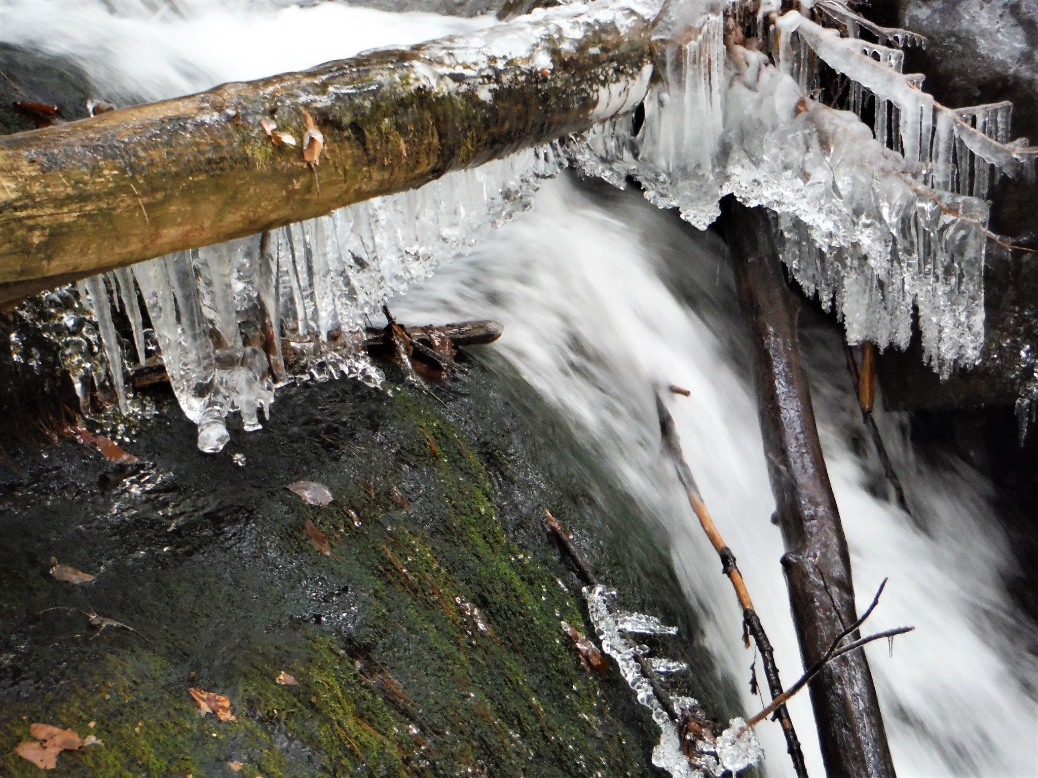
Apr 8 - BIG HOLLOW BRANCH waterfalls bushwhack. Found another old woods Rd. I named the falls. Dam Falls:
Mini Gorge Falls:

Big Slide Falls:

Apr 3 - TOWN OF BOLTON CONSERVATION PARK. Views of The Pinnacle & Cat Mountain.
Mar 26 - Ice out on Lake George!
Mar 25 - Ice breaking up at Hearthstone Point.
Mar 21, 2021 - Biked up the Prospect Mtn toll road to past the 3rd lookout. After that, there was hardpack snow (icy in spots that don't get much sun) over all the road. Walked to where the WHITE trail (see Nov 14, 2020) crosses & followed it N a short distance to a brook. The white trail continues on the other side (you can see 2 markers in the upper L of the pic below) but I was reluctant to cross the brook - will return soon when the snow is gone to see where it goes. Temp rising thru the 50s.
Feb 19, 2021 - Ski from Shepard Park. 1.5" fresh powder, hit 1 wet spot.
Feb 15 - 3 loons rescued off a small piece of open water (near Hague I believe).
Feb 10 - Ski from Shepard Park. There was a plowed "road" on the lake from Shepard Park to the state boat launch then I headed N on the lake. A fisherman told me the ice was 7" thick. Very good kick & glide skiing. A 20' area had some wetness but skis did not stick or ice-up. 2 hours.
Jan 13, 2021 - RATTLESNAKE COBBLE. Short hike up the red trail, L on the toll road & up the cobble (view of the Northway) from The Narrows overlook (nice view to the lake). Some icy base, 1-2" powder, used spikes for traction. It has been a gloomy, sunless week - had to force myself to get out. Temp around freezing. 1.8 hours.
What does Santa do on New Year's Day 2021? Still seeing buffleheads & goldeneyes.
Dec 29, 2020 - Loop hike. Started up the red Prospect Mtn Trail (not much snow), then R on the Prospect Mtn Memorial Highway (dusting of snow) to the Lake George Panorama lookout. Back down the road to The Narrows lookout.
 Further down the road
& R on unmarked trail just before Stannard Pond. Gained 350' (1-5" of crusty snow) then L on Prospect Mtn south trail & soon L again at the cairn
onto shortcut marked with faded blue paint blazes, L again at boulder with marker rocks
down to the LGRC.
Stayed as close to West Brook as possible. Checked out the lean-to & falls.
Quick stop at Ore Bed Reservoir
then down to the toll road & looped back to start on village streets. 7.1 miles, 1,191' elevation gain, 3.7 hours.
___________________Dec 15 - LG REC CTR & PROSPECT TRAIL. From the lean-to, up the L side of the falls on West Brook

Followed on L side of the brook to bridge over the brook & continued up, soon passing into State land. The old logging road bears L before crossing a tributary (a sharp R is the shortcut & best way if going to the summit). Going NW, it is steep for a while & arrives at a junction - a L soon reaches, a gate & private land, NW looks like it may go toward the radio towers (on the to-do list now), I bore R going downhill & crossing a couple of brooks. The trail leveled out a bit & the branches on young hemlocks were head high
& passed the shortcut trail & cairn that marks its N junction.
A short distance further I bore R (leaving the Prospect trail) dropping down fairly steeply going NE with a view of Rattlesnake Cobble thru the trees.
Eventually crossed a small brook on logs that someone had set across the water.
A sharp L soon led to the toll road just above Stannard Pond.
Headed down the road with view of the lookout cliffs on French Mtn. R on snowmobile trail back to the Rec Ctr.
4.2 miles, 2.2 hours, 1,500' gross el.
Dec 11 - Started up the PROSPECT MTN red trail (it's easier walking on the path just to the S of the marked trail) then R on the toll road. View from LG Panorama:
View from Eagle's Eye:
Shady areas of the road had a coating of snow.
After going about 2 miles on the road, went R into the woods & soon spotted a white marker which soon led me to an old logging road leading W, unmarked but obvious. Crossed a small brook
then rock-hopped Big Hollow Branch
& soon hit Big Hollow Rd & went L, some icy spots were easily avoided.
Checked out the beaver dam at Big Hollow Reservoir, small pines grew in the openings.
Up the road a bit then bushwhacked NE but soon found an old logging road going E.
Saw the toll road up to my L & headed back. 7.4 mile, 3.7 hours, 1,250' el gain. _____________________
Dec 8, 2020 - The goal for the day was to see where I had gone wrong on 11/29. Started up the red trail then R on the toll road all the way up - longer but just a gentle grade, a dusting of snow, temp in upper 20s. PROSPECT MTN 3.8 miles from start.
Down on the unmarked trail to the Rec Center. Still some wet spots. Soon goes down a steep rocky stretch (could be tough on skis) with thru-the-trees view of the lake then eases somewhat. The route bears R at a junction (L may go to the toll road - now on the to-do list) then L at a cairn on a narrower trail. See some faded blue paint blazes. Reach the old logging road again just below the 11/29 stream crossing - a downed tree partially obstructs the junction & the cairns are not real obvious.
Ice starting to form on West Brook.
Rec Ctr parking area at 6.4 miles. Saw 3 people going up while I was coming down. Lake George Recreation Center ski trail map:
_________________
Nov 29 - PROSPECT MOUNTAIN. Up from LG Recreation Center on unmarked trail, down on red trail to Smith St. 5.1 miles, 3.4 hours. Falls on West Brook:
Crossed a bridge & continued along E side of the brook. Crossed to W side of the brook half way up
going NW on a wide trail, reached an intersection & things did not seem right so I bushwhacked NE for half an hour & finally hit the right trail - the whack was dry but the trail had large wet spots. Soon reached the S end of the summit parking area.
View of Black Spruce Mtn: Favorite view:
Left the upper red trail & went down thru route of the old tramway:
If you don't have 2 cars, it is a 2.2-mile 45-minute walk between trailheads.
__________
Nov 21 - STANNARD POND & WEST BROOK loop. 1 car parked on Smith St at 9:15am. Up the Prospect Mtn red trail to the toll road, saw 2 hikers. L on road to The Narrows overlook.
=
Continued S downhill on the road, saw 2 bikers & 1 jogger. Stopped at man-made Stannard Pond & took in the reflections. After crossing West Brook, took a R on snowmobile trail & soon arrived at the ballparks in LG Recreation Area.
Up the road then R at a building & soon reached an impoundment on West BrooK (Ore Bed Reservoir is an old water supply reservoir on West Brook).
A bit further to the lean-to (no camping) & waterfall.
Back to the toll road
then out to Rt.9 & sidewalks thru the village back to start. Fun exploring, even tho a lot of the route was on pavement.
6.5 miles, 935' gross elevation gain, 2.7 hours.
____
Nov 14, 2020 - The goal for the day was to hike up to PROSPECT NE & to see where the unofficial WHITE TRAIL goes. ~25 cars parked on Smith St at 12:30pm, temp in the low 40s. Quite a few people on the red trail. Took a R on the unofficial blue trail to the top (1,500' gain, 75 minutes) then R on white, which heads NW, drops steeply at first, then just moderately, then up gently to a small nubble.

Some thru-the-trees views. Blue had definite foot tread but white had seen little or no traffic & if it wasn't for the regular markings would have to be considered an easy bushwhack thru open woods. Dropped very steeply again & after 30 minutes from the top arrived at the toll road. Saw no-one on blue or white. Down on the road, could see Big Hollow Branch not far down, Shingle Mtn (1,959') rises steeply on the other side of the valley. Stopped at Eagle's Eye viewpoint for a nice view:

Further down the road, the view from Lake George Panorama viewpoint:
Saw 1 runner, 2 bikers & 2 vehicles on the toll road which is supposed to be closed for the season. Back down the red trail & bridge over the Northway. More people. 3 hours total.
Nov 9 - BIG HOLLOW & BLACK SPRUCE MOUNTAIN via Big Hollow Rd trail. 1 pickup parked not far from the culverts but I saw no-one all day. Just before Big Hollow Reservoir, I took a R on the trail going toward Viele Pond Rd to check it out for skiing. Fairly flat compared to that climb up BH Rd trail. Nice beaver pond on the way. Further along, the old road/snowmobile trail enters private land & I turned back & stopped at the pond for a peaceful lunch. Plenty of time left on this beautiful 70-degree day, so crossed the outlet of BH Reservoir & followed a less obvious unmarked old road SW, S, SE just to check it out - hoping it was a route up BS Mtn - I did not plan to summit it today but I was feeling good & just kept on going - it got quite steep, some flagging helped at a spot where the "trail" was less obvious. It turned SE looking like it was going to Prospect Mtn, so I decided to bushwhack SW thru fairly open woods & made it to the wooded top, elevation 2,359' (over 300' higher than nearby Prospect, Buck is 2,334', I think BS is the highest mtn on the W side of Lake George). With the leaves off the trees, there were obstructed views of Lake George. Spotted a bunch of flagging & saw a stone USGS marker there & then found the benchmark nearby, also a mini "canister" for folks to sign in. Bushwhack back went well (you can't get lost on a sunny day, I did not use compass or GPS today) & picked up the unmarked trail. Back to start in 1.6 hours. Grouse. 5.7 hours.

Nov 4 - PROSPECT MOUNTAIN. Started up the red trail, across the toll road (closed today, closed for the season Nov 11), up a little on the red trail then R on the unofficial blue trail marked with paint blazes, up steeply then very steeply. Blue trail is less rocky than the red trail. Some patches of snow down low but up to 1" up high. L on unofficial orange trail, fairly flat, some thru-the-trees views, comes out on the red, up to the summit which I had all to myself, wind chill, temp ~50F. Down a bit on red then L on blue, flat for a bit then up steeply to 1,900' peak which has filtered view. Noticed an unofficial white trail going N - more to explore next time. Continued down on blue to red. On the way down, could have used spikes above 1,700' but poles really helped. 3.5 hours.

Sun Oct 25 - PROSPECT MOUNTAIN & BIG HOLLOW loop hike, from Cooper St, LG. Up the mountain early & got to the top in 75 mins. Saw 3 people going down. The 1st car (DEC) of the day arrived just after I got there. Picked up the old road/snowmobile trail to Big Hollow from the NW corner of the parking area - fairly obvious but not much in the way of markers. Dropped 600' in a mile to Big Hollow Reservoir - the old stone/earth dam (there is an old foundation nearby) was breached & there was not much water in the pond, the beavers have built a small dam. Met 3 hunters. Continued down on Big Hollow Rd (4wd trail) never far from a powerline. Lots of hemlocks. Scenic ravine on the R with Big Hollow Branch & its cascades, waterfalls & slides. Under I-87 via a big driveable culvert. 4.7 miles, 3 hours. I did not spot a car so had a 35-minute road & sidewalk walk back to start.

Thu Oct 22 - RATTLESNAKE COBBLE from Cooper St, LG. Started on the Prospect trail & soon went off-trail to the SW. Hit the toll road 100 yards from The Narrows parking area - nice views to the lake here. RC trail starts at the back of the lot & winds to the R then L up steeply for a bit (1st yellow trail marker here). Thru some nice oak woods with white pine saplings. View S from ledges to I-87 & Darling Mtn. Small view of the lake. Visually nice but too much road noise. Walked the road from the parking area to the Prospect trail in ~5 minutes. 800' el. gain. 2.3 hours.

Thu Oct 15 - PROSPECT MOUNTAIN from Cooper St, Lake George. I generally try to avoid hiking up mountains that have a road to the top but I had never hiked this one before, & it was a weekday with nice weather & colorful foliage. Sort of scary going over that enclosed bridge over I-87. Then straight up the rocky trail over the route of the old cable railway. Crossed the toll road & continued up over a lot of smooth bedrock. A gain of 1,600' over 1.6 miles. Main view is over highway & village - I like views with little or no signs of civilization. I preferred the view from a spot on the road between the parking area & the actual summit which looks toward The Narrows, Black, Tongue, Cat, Thomas Mts with High Peaks in the distance. The temp rose to ~70F but windy on top, views a bit hazy. Probably ~100 people scattered around the summit area at mid-day, ~40 cars in the parking area below the summit - probably will be more crowded on the weekend. 80 min. up, 55 min. down.

Sun Oct 4, 2020 - THE PINNACLE from Edgecomb Pond Rd. Gain of 480' in 1.2 miles, 1.4 hours. Shared lookout with ~20 others, more going up as I came down. Views of the Narrows, Black & Buck Mtns - better than Schumann. More small ledges on S side with views of pond at Conservation Park, Cat Mtn & Crane Mtn in the distance. 20-50% color change. More info.
Trout Lake:
MinneHaHa seen from Hearthstone Point Campground (closed for the season):
Tue Sep 22 - SCHUMANN PRESERVE at Pilot Knob Ridge. A fairly steep climb to the gazebo, rock steps & switchbacks help, also dry & fairly smooth, climbs 600' in 0.7 miles. Good view of part of Lake George incl. Cleverdale & Long Island. On the other side, Black Spruce, Cat & Thomas Mtns; further in the distance were Crane & Gore Mtns. Continued on the blue trail & the waterfall loop - not much water going over it today but it is a cool spot. Saw ~20 people on the orange trail, just 1 group of 7 on the blue trail - would not go here on the weekend. 4.2 miles, 900' gain, 3.2 hours. Info.


Sept 13, 2020 - FRENCH MOUNTAIN CLIFFS, from the Warren County Bikeway. A yellow arrow on the bike path points to the start of the trail, then blue markers. A few semi-muddy spots near the start, dry the rest of the way, sneakers were sufficient. Gentle grades early then gets steeper. View of a small part of Lake George, Potash Mtn in distant W, Rt.9 & the I-87, the Outlet stores, $ General - above-average road noise the whole way - not very peaceful. NE of the cliffs is a gravel road leading past a commercial zipline. 1.4 hours, 800' gain.


Sept 6, 2020 - PILOT KNOB from Buck Mtn trailhead. Short way up blue Inman Pond trail then a R on unofficial trail, axe blazes on trees, soon crossing dry streambed. Then the path, marked with red paint blazes, started climbing with a vengeance thru open rocky nice-smelling hemlock & pine woods. Lots of zigzags. Good dry foot-tread helped me stay on course. Several good look-outs above 1,500', I got to the nubble at just under 2,000' & hung out - no-one else around (12 people went down as I went up). Open area with blueberry & oaks. Could see to the High Peaks, Crane Mtn to the W, Stratton & Snow in VT. The actual 2,163' summit of Pilot Knob loomed closeby to the SE - I am not aware of any paths or trails that go there. Scouted the trail going down to the SE but gonna leave that for another day. The only real negative was the constant hum of motorboats on Lake George, otherwise an interesting fun hike. Minimal bad bugs. When I got back to the trailhead in mid-afternoon, there were 50+ cars in the parking area & 60+ more parked on the road! Most folks headed to Buck. 4.6 hours, 1,600' elevation gain.


Sept 3, 2020 - WALNUT RIDGE & POLE HILL POND counterclockwise loop, from Rt.9N, N of Bolton Landing. Rained yesterday, the trail was wet but not really muddy, some wet spots near the pond. A bit of a view of Lake George on Middle Mtn but a very nice view from the ridge after ascending 1,200', could see most the southern part of the lake across to Buck Mtn. Lots of different fungi, a few red efts. Variable mosquito activity. Saw only 1 other person. 6.5 miles, 4 hours.


Wilderness Rescue: On Oct. 2 at 9:30 p.m., Warren
County 911 transferred a call to DEC's Ray Brook Dispatch from two
hikers who became disoriented on Pole Hill Pond. The hikers, from
Brookhaven, did not have a light source or warm clothing with them as
temperatures dropped. Dispatch advised the hikers to stay where they
were until help arrived. Warren County 911 shared coordinates to the
hikers' location as their only working cell phone battery died. Forest
Rangers Donegan and Kabrehl responded to assist, arriving on scene at
10:30 p.m. Voice contact was made at 12:15 a.m., and the hikers were
found off the trail at 12:33 a.m. Forest Rangers escorted the couple
back to their vehicle at the trailhead.
Wilderness Rescue: On Oct. 3 at 7:53 p.m., Warren
County 911 transferred a call to DEC's Ray Brook Dispatch from a hiker
stating that she and her eight-year-old daughter were stuck on the trail
for Pole Hill Pond. The hiker stated that they did not have any light
sources and that she had fallen, causing minor injuries. Forest Rangers
Donegan and Kabrehl responded to the pair's location along with Bolton
Fire and EMS. Rangers proceeded up to the trail to locate the stranded
family from Saratoga Springs and Ranger Donegan advised that he was with
the pair at 10:48 p.m. After being assessed by Rangers, the mother and
daughter were provided light sources and safely escorted back to the
trailhead. At 10:58 p.m., the incident concluded and all emergency
service providers were cleared the scene.
Nov 29, 2005 - 5 MILE MOUNTAIN hike. Part of the Tongue Mt. Range to the W of Lake George. Started from the N trailhead on Rt.9N. Fair amount of blowdown from yesterday's wind/rainstorm - I used to be the volunteer trail-adopter for this trail & I couldn't help but spend some time clearing debris (much pine) along the way. Oak leaves carpeted the way early on & changed to pine needles at higher elevations. At Brown Mt. (after a 900' climb) there is a lookout across the Narrows of Lake George to Black Mt. & the Green Mts. beyond. At the leanto (which now has a new wood floor) there are views of the High Peaks. Trail passes thru an attractive red pine grove with some ups & downs before reaching 5 Mile Mt. 1 mile past the leanto. The actual summit is easily missed - when you see a lot of rock to the R or W leave the marked trail & find a way to the top - there is barely a herdpath - a USGS marker embedded in the rock confirms you are on the summit. Views are best to the E (Vermont). To the SW there are some rock ledges with great views S & W - Northwest Bay below, Crane & Gore Mts. stand out among the low peaks. Donned Outdoor Research hat (note: Polartec WindPro is a tight fleece weave making it wind-resistant & quite breathable whereas Gore WindStopper is fleece with a membrane in it making it windproof & somewhat breathable) mittens & sipped on hot chocolate. Back to trail & continued S for a few minutes to a rocky lookout E - the Mother Bunch Islands below Black Mt. Headed back with a short detour on the Deer Leap trail to a lookout with views to Huletts Landing. Grouse, ravens, chickadees & a couple of wild turkeys (with smirks on their faces having escaped the Thanksgiving dinner table). Very peaceful today - it was nice not seeing any motors on Lake George. OR gaiters helped keep pantlegs dry. Brought along instep crampons but didn't use - a little bit of ice on rock at higher elevations was easily avoided. 8 miles, 6.25 hrs., 1,200' elevation gain from trailhead to 5 Mile Mt. Still waiting for snow.
Visit us on Facebook
Welcome to the Adirondacks NYSDEC Info


.JPG)
.JPG)
.JPG)
.JPG)
.JPG)
.JPG)
.JPG)


.JPG)
.JPG)
.JPG)
.JPG)
.JPG)
.JPG)
.JPG)

.JPG)
.JPG)
.JPG)
.JPG)
.JPG)
.JPG)
.JPG)
.JPG)
.JPG)
.JPG)
.JPG)
.JPG)
.JPG)
.JPG)
.JPG)
.JPG)
.JPG)
.JPG)
.JPG)
.JPG)
.JPG)
.JPG)
.JPG)
.JPG)
.JPG)
.JPG)
.JPG)
.JPG)
.JPG)
.JPG)
.JPG)
.JPG)
.JPG)
.JPG)
.JPG)
.JPG)
.JPG)
.JPG)
.JPG)
.JPG)
.JPG)
.JPG)
.JPG)
.JPG)
.JPG)
.JPG)
.JPG)
.JPG)
.JPG)
.JPG)
.JPG)
.JPG)
.JPG)
.JPG)
.JPG)
.JPG)
.JPG)
.JPG)
.JPG)
.JPG)
.JPG)
.JPG)
.JPG)
.JPG)
.JPG)
.JPG)
.JPG)
.JPG)
.JPG)
.JPG)
.JPG)
.JPG)
.JPG)
.JPG)
.JPG)
.JPG)
.JPG)
.JPG)
.JPG)
.JPG)
.JPG)
.JPG)
.JPG)
.JPG)
.JPG)

.JPG)
.JPG)
.JPG)
.JPG)
.JPG)
.JPG)
.JPG)
.JPG)
.JPG)
.JPG)
.JPG)
.JPG)
.JPG)
.JPG)
.JPG)
.JPG)
.JPG)
.JPG)
.JPG)
.JPG)
.JPG)
.JPG)
.JPG)
.JPG)
.JPG)


 Further down the road


 Further down the road, the view from Lake George Panorama viewpoint:


Comments
Post a Comment