EAST BRANCH SAINT REGIS RIVER paddling
June 30, 2022 - The 22-mile-long East Branch flows out of Meacham Lake, travels northwest, drops 20 feet at Everton Falls before turning south, and soon joins the main branch of the St. Regis River near Santa Clara. To get to the put-in from NY 30, drive west on Red Tavern Road (CR 14) for 8 miles and look on the right for a parking area at The Nature Conservancy's (TNC) Everton Falls Preserve. You may want to take a short walk further along the road to get a look at the falls before carrying your canoe or kayak across the road and down a 125-foot trail to the river above the falls.
Upstream, you will find over 9 miles of flatwater – you will be going against the current but you can turn around whenever you desire and return with the flow. Three days before our trip, it had rained well over an inch and the current was still very noticeable – we paddled upstream for 2.5 hours, and returned in 1.5 hours!
The first mile or so passes through lands owned by TNC, after that you are on state Forest Preserve lands within the Debar Mountain Wild Forest. After going about 1.5 miles, there is a brief section of quickwater where you must paddle a bit harder for a couple of minutes.
The 60-foot-wide river then meanders through meadows of tall grasses or is bordered with alders beyond which the spires of black spruce poke up in the near distance. I was amazed at the diversity of flowers seen along the way – I spotted Joe Pye weed, purplestem angelica, blue flag, cow vetch, meadow-rue, bullhead lily, and shooting stars.
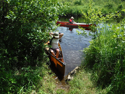
After traveling upstream for 4.8 miles we reached another access point – this requires a drive along a dirt road from NY 458 plus a 5-minute carry – this little-used access is easy to miss from the water if you are not looking for it. We stopped here, in a small grassy area, for lunch – unfortunately, the local mosquitoes decided to have lunch at the same time. Thankfully, biting bugs were absent while we were on the water while bug-eating damselflies flitted about in abundance.
After lunch, we headed back downstream at a relaxed pace – I felt like I was expending so much less effort in this direction and stopped many times to photograph items of interest. Parts of this river reminded me of the Oswegatchie above Inlet except for the fact that there are no beaver dams on the East Branch. The East Branch does have a population of beavers though, however, the water is generally deep enough for them so there is no need for them to dam this river. We saw no other humans on this trip. 9.6 miles, 4.8 hours.
.JPG)
.jpg)

.JPG)
.JPG)
.JPG)
.JPG)
.JPG)
.JPG)
.JPG)
.JPG)
.JPG)
.JPG)
.JPG)


Comments
Post a Comment