ESSEX CHAIN COMPLEX xc skiing
Mar 8, 2020 - THIRD LAKE & JACKSON POND ski. Essex Chain Lakes Complex. From near the east end of Goodnow Flow in Newcomb. Chain Lakes Road North for over a mile then R on blue trail to Third Lake (1,599' el.) - good view of 3,750' Blue & 3,573' Dun Brook Mtns - crossed lake to W side for lunch at a snow-free spot lakeside, 68 degrees in the sun. Back across to spot where the 10 buildings of Gooley Club used to be & picked up a short unmarked but obvious trail to Jackson. Picked up the yellow trail at the pond's E end & looped back to blue trail. Good to very good skiing with temp 35-45F - a bit faster at start, slower on return. All base (15-20", no powder) - felt more like early April. ~11-12 miles on easy road-like trails. 5.3 hours. Area gets some light snowmobile activity, illegal I believe.
Mar 15, 2015 - UPPER HUDSON RIVER SKI LOOP. Story
Jan 25, 2015 - ESSEX CHAIN LAKES from Newcomb. Chain Lakes Rd North leaves Goodnow Rd for 1.3 miles then R thru gate. At 2.5 miles from start took R on another good dirt road (seen as double broken line on USGS map). Sixth Lake seen on L, rolling trail, Fifth Lake on L. Much evidence of logging. Stopped on NW shore of Fifth for lunch - good sun & little wind, comfortable despite temp barely in double digits. Good view of Vanderwhacker Mtn. On to the culvert between Fifth & Fourth Lakes passing a new accessible outhouse. Stopped at campsite #2 on Sixth. All trails had some snowmobile use - ranger said it was illegal for sleds to go N of the lakes; out of tracks there was 6" of powder on hard icy base - very good skiing. Easy terrain. Temp in single digits at start & finish. Several snowmobiles came out of Polaris Club camps. 10.85 miles, 5.2 hours.
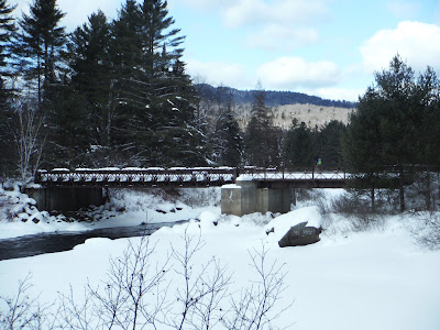
Feb 3, 2014 - ESSEX CHAIN OF LAKES from SE end of Goodnow Flow, Newcomb. Former Finch/Pruyn lands. Fourth & Fifth Lakes. Side-trip to the Iron (aka Polaris) Bridge over the Hudson River, camps of the Polaris Club on the E shore. All on unmarked woods roads, the 3 mile route to the Hudson had seen some snowmobile & ATV use, we broke trail to the lakes (no signs or markers, helps to have the USGS Newcomb map + GPS). To go to the lakes, at 1.4 miles we took a R past a metal gate going straight for over 3 miles then a R (a barrel filled with waders, boots, fishing rod & more sat at the intersection) to Fourth & Fifth Lakes. Views of Blue Mtn, Sixth Lake Mtn & Cedar Mtn along the way. Gently rolling novice terrain a bit like Camp Santanoni. 6-10" powder (fluffier than yesterday) on sometimes icy base - very good to excellent skiing. There is a kiosk & register 0.8 miles before the Hudson River, view of Vanderwhacker & Polaris Mtns to the E, all downhill down to the bridge. 14.9 miles, 5.7 hours. The Town of Newcomb is plowing Goodnow Flow Road. The public can park in the designated plowed area along the Goodnow Flow Road just before the Chain Lakes Road entrance – this is the road used in the summer to access the Hudson River at the Polaris or Iron Bridge. The public can access the Essex Chain Lakes Tract to ski, snowshoe or otherwise traverse the roadways and the lands. Interim winter public access will be limited this year as no plowed parking areas have been designated on the Essex Tract itself. The plowed parking area on the Goodnow Flow Road is used by the Gooley and Polaris Club members to park vehicles and snowmobile trailers . The Deer Pond and Chain Lakes Road gates have been closed and locked. The roads beyond are closed to public motor vehicle traffic until the end of the spring mud season. Members of the Gooley and Polaris Clubs will be able to use snowmobiles on the roadways to get to and from their camps.
From the south, Outer Gooley Club building: On December 1st 2013 the Chain Lakes Road from Route 28 in the village of Indian Lake was plowed to the area just past the dam at the north end of Lake Abanakee. We were able to drive a short distance past that point in icy tracks and five inches of dense slightly-crunchy snow but decided to park the cars early and don the skis. It was almost a two mile ski over rolling terrain with views of the Indian River to the first summer parking area then another 0.7 miles to the old Outer Gooley Club building with its view of rapids on the Hudson River. Another three miles of gentle hills led us to a short spur trail ending at the Cedar River. We ended up skiing 11.5 miles in 4.5 hours that day.


Comments
Post a Comment