Jan 2025 - The bridge over Mill Brook on the Pharoah Lake Trail is out. This bridge is located a little over 1 mile from the trailhead. The Pharoah Lake Trail is closed at that point. The Crab Pond Trail can still be accessed from the Pharoah Lake Trail prior to reaching Mill Brook.
Jan 18, 2024 - CRANE POND, GLIDDEN MARSH, & OXSHOE POND xc ski. Pharaoh Lake Wilderness. Started out on the old woods road, with some nice views down to Alder Creek & icy waterfalls, more washouts with mini brooks crossing the old roadway than my last time here. Icy base topped with up to 6" of powder - less powder was usually under hemlocks. I skied out onto CP & GM - the ice felt solid. The bridges over CP outlet (Alder Creek) & GM outlet were in good shape. A little before GM we had to detour around some blowdown. The steep climb from GM was best done by zigzagging up (& later down) off-trail. OP was lovely as usual - lunch at the lean-to. Views of Pharaoh Mtn from certain points on the route. ~1' snow depth, skiing was mostly good, sometimes just ok or very good. Temp in the upper teens to low 20s. 7.9 miles, 731' gross el gain/loss, 5.3 hours (slowed down by some equipment malfunctions - duct tape time). Elevations varied from 990' at the start & 1255' on the OP trail.
CROSS COUNTRY SKIING in the PHARAOH LAKE WILDERNESS
Many winters ago, I went on my first real backcountry ski tour into the wilderness and Pharaoh Lake was the destination. Dressed in cotton corduroy pants and other layers of cotton clothing, plus wool sweater, gloves, and hat, I was semi-prepared for the task. Without gaiters, wet snow loved to cling to those pants. At the Watch Rock lean-to, my buddy revealed a pint of whiskey which we shared, and, on the return, my skiing skills deteriorated somewhat, but I was able to avoid serious injury and had a great time. These days, now much wiser and less ignorant, I don't wear cotton clothing on the trail, I refrain from consuming alcoholic beverages on the tour and I still have a great time.
Lake-effect snows often hit the Tug Hill area east of Lake Ontario and the western Adirondacks but seldom reach the eastern Adirondacks, so the Pharaoh Lake Wilderness, located east of I-87 and Schroon Lake, generally depends on whatever snowstorms come through its way. Fortunately, there are some trails that one can ski when there is less than a foot of snow on the ground. The area features piney woods and many ponds as well as several small mountains. Only two of the mountains have marked trails to their summits - Pharaoh Mountain and Treadway Mountain - but many of the trail-less mountains have good views after easy bushwhacks which are probably best done on snowshoes rather than skis although advanced level skiers could manage with the help of climbing skins.
CRANE POND.
The trailhead is at the end of plowing on Crane Pond Road in the northwest section of the wilderness area. It is an easy 2-mile ski along an old dirt road to the scenic 1-mile-long pond and 6 inches of snow would be sufficient to make the trip on skis. Less than a mile into the trip, there is a photogenic, icy waterfall on Alder Creek that always tempts me to drop down for a closer look and, soon after, the 0.6-mile trail to Goose Pond is passed. After that you get some gentle hills and, at around 1.5 miles, you have a choice of continuing on the old road across a stretch that is flooded in other seasons or following trail markers through the woods around the north side of the flooded area, then picking up the road again on the other side. There are views of Pharaoh Mountain across Alder Pond before reaching the shore of Crane Pond near its outlet. Ski out onto the pond and you can make this into a 6- or 7-mile round-trip. Sunny campsites along the pond's north shore make for good lunch spots. There are good views of Pharaoh Mountain to the south, plus views of lesser peaks such as Bear Mountain which was ravaged by fire in September of 2015 to the northeast.
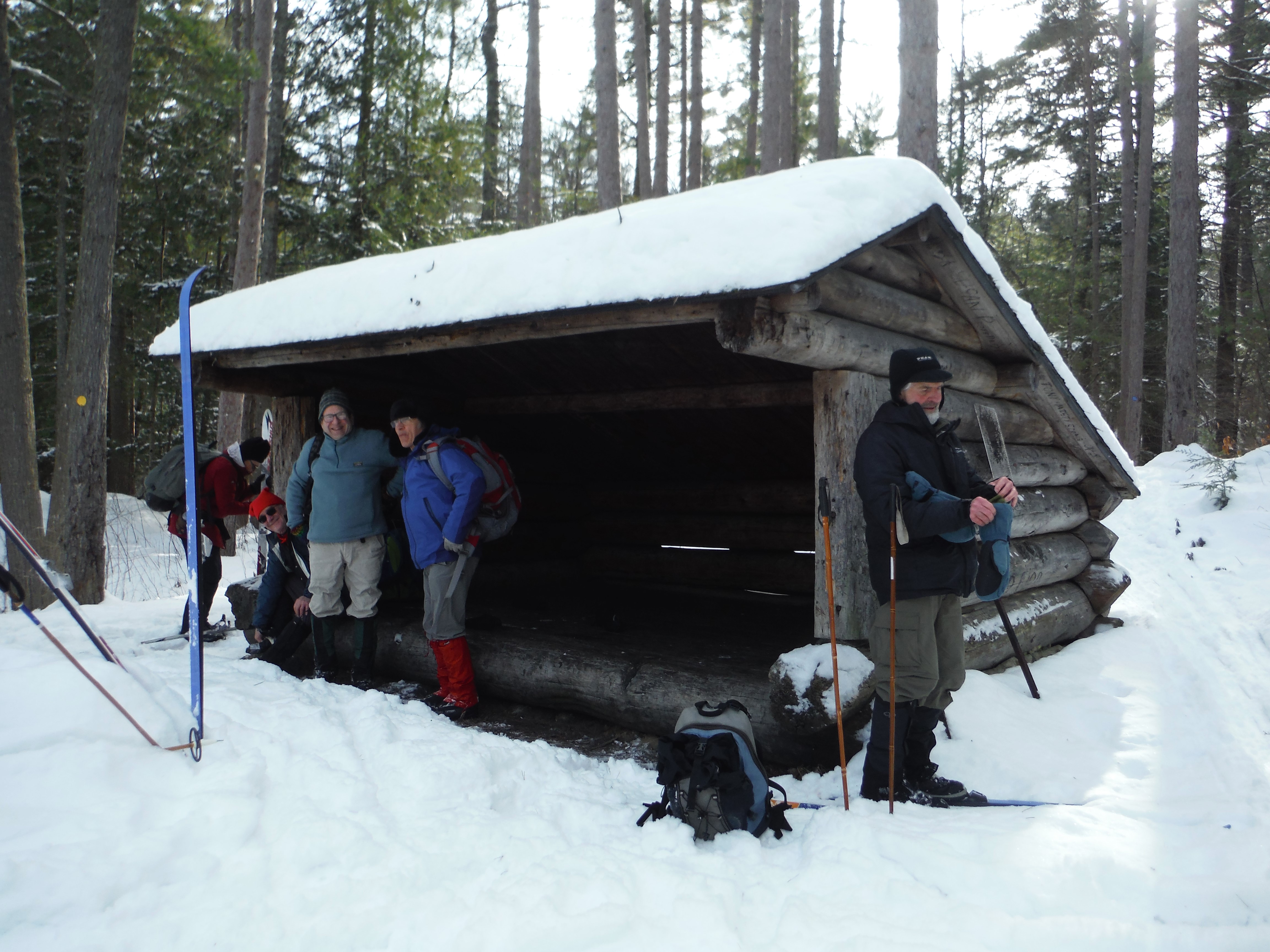
Intermediate skiers can continue across the outlet and ski 1.1 miles to Glidden Marsh then take a left on the trail to Oxshoe Pond which initially climbs steeply but soon reaches a lean-to at an attractive spot on the pond. Some winters ago, while relaxing at the lean-to, we were entertained by white-winged crossbills and pine grosbeaks that seemed unperturbed by our presence.
PHARAOH LAKE.
Pharaoh Lake is the third biggest lake in the Adirondacks that is totally surrounded by designated wilderness lands. The lake is most easily reached from the southwest and the trail to it can be skied when there is 10 inches of snow on the ground. From Beaver Pond Road, a good parking area with an outhouse is reached by driving a short distance on Pharaoh Road past some camps to the end of plowing.
Skiers continue on the relatively flat old dirt road for 1.1 miles to a crossing of Mill Brook. A little before Mill Brook, a newly-marked yellow ski trail heads east to Crab Pond (the southerly one of two Crab Ponds in the Pharaoh Lake Wilderness), a small but scenic wilderness pond that sits in a bowl-like setting surrounded by mountains that rise steeply up to 500 feet above the pond – this is a more challenging ski with undulating terrain. After skiing about 1.5 miles, the ski trail crosses the outlet of Crab Pond above a waterfall and soon reaches the north shore of the pond; the hiking trail forks right before the outlet and goes up and over a small hill then steeply down to a campsite near the end of a peninsula.
Back on the Pharaoh Lake Trail, after crossing Mill Brook, the route climbs gently for 1.3 miles to a bridge over Pharaoh Lake Brook – if you take a left before the bridge you will find a piney campsite with a great view across a vly to the cliffs on Pharaoh Mountain. After the bridge, it is another 1.2 miles to Pharaoh Lake. Trails continue around the lake but skiers will find it simpler to ski out onto the lake. From Watch Rock, near Lean-to #5, one of six lean-tos on the lake, the panoramic view takes in most of the 2-mile-long lake as well as Pharaoh and Treadway Mountains. The direct round-trip to and from Watch Rock is about 9 miles.
BERRYMILL POND.
Berrymill Pond is in the eastern part of the wilderness area. At an elevation of around 1,700 feet, Berrymill is one of the higher elevation ponds in the area. The trailhead, at the end of Putts Pond Road, is near the boat launch on the east shore of Putnam Pond. The town plows the road to the Lost Pond trailhead regularly, the last mile to the pond, the state's responsibility, is sometimes not plowed - this could add 2 miles to a round-trip.
The trail, mostly on an old road, slowly gains close to 400 feet in 2 miles. At about the 1.5-mile mark, the trail detours to the right to avoid a beaver flow and crosses a stream on a narrow bridge, then the trail returns with some short but steep ups and downs back to the old road. After skiing 2 miles, at a junction, a right turn soon leads to a new lean-to with a lovely view of the pond's outlet bays and is near a waterfall on the outlet – to get a good look at the main part of the pond you may have to bushwhack a short distance. Evergreens, including white pine, balsam fir, and hemlock, dominate the area.
After the junction, the main trail is skiable south for at least another mile or two. The return to your car is mostly an enjoyable downhill run.
There are more trails to ponds and lean-tos in the wilderness area that can be skied by intermediate skiers given a foot or more snow – I have skied to the other Crab Pond as well as Lilypad, Clear, Rock and Little Rock Ponds - give them a try. More information can be found in guidebooks and on the NYSDEC website https://www.dec.ny.gov/lands/107648.html although the new trail to Crab Pond is not shown accurately.
Feb 17, 2008 - OXSHOE POND. ~2' of snow, light breakable crust off-trail; most trails broken out by skiers & snowshoers; skiing was good. Pharoah Wilderness. Goose Pond, off-trail alongside Alder Pond, Crane Pond, Glidden Marsh, broke trail to Oxshoe Pond & leanto (nice spot), back out via Crane Pond Rd. Views of Pharoah Mt from GP, GM & CPR. Nice woods: lots of pines & hemlocks. 7+ miles, 4.6 hours.
Mar 7, 2005 - CRANE & OXSHOE PONDS in Pharoah Wilderness near Schroon Lake. Temp upper 20s to low 40s - cloudy at first but then mostly sunny. 2 miles to Crane is along an old dirt road - easy intermediate - thru wonderful stands of towering white pines & hemlocks. Trail crosses outlet & passes thru attractive woods (add birches to the pine/hemlock mix) to Glidden Marsh & a good view of Pharoah Mt. Quite the variety of animal tracks en route. We take a L & climb steeply (do some switchbacks offtrail - "think out of the tracks") for a while before continuing on to leanto at Oxshoe Pond. The pond has steep rocky shorelines & is surrounded by beautiful red pines. Skied around its perimeter & up & down some of the steep rock just for the fun of it (some 30' drops at 45° angle). After a short siesta, skied back out the way we came. Billions of snowfleas were out sunning themselves. The route to Crane Pond is well-used but the further we went the less evidence of previous travellers. Intermediate. 7.5 miles, 5 hrs. Karhu Pyxis skis. Use Maxiglide XC Quick Wax on bases of nowax skis when temp is above 20°F to prevent sticking.

Feb 14, 2005 - PHAROAH LAKE ski from Beaver Pond Rd. 5"(on trail)-10"(in open areas) powder on icy base - popular trail was well-tracked from the previous day. Temp rising thru the 20s. Good skiing but some rocks exposed - could use another 6" to sweeten things up. Fairly flat for over a mile along unplowed rough dirt road to wilderness boundary at Mill Brook then slowly gain 250' in next 2.4 miles to the lake. Last mile is thru attractive hemlock/white pine/birch forest with glimpses of Pharoah Mt. across the beaver flow on Pharoah Lake Brook. Skied along S shore of lake to Leanto #1 & spread out the Thermarest for a long break - view across the lake to Treadway Mt. Started snowing mid-afternoon. Glide out took 1.5 hrs. Easy intermediate. 8 miles, 5.2 hrs. Karhu Pyxis skis, leather boots.
Feb 22, 2004 - LILYPAD POND ski, S from Rt.74 in eastern Adks. 2' snow - off-trail: thin breakable crust with 3" new wet powder on top, soft dry snow underneath. Temp a bit above freezing - use Maxiglide on nowax skis to prevent snow from sticking to ski bottoms. Short Swing Trail in Pharoah Wilderness . Start of trail has some small sharp ups & downs before crossing the outlet of Eagle Lake on a good bridge. After over a mile the trail makes a long gentle climb (sweet run on the the way back) to the SW of Ragged Mt.'s cliffs before dropping sharply to Tub Mill Marsh & leanto at 2.4 miles. The marsh offers some interest & views. After crossing Rock Pond Outlet (mostly frozen but some holes in ice where you can see water) the trail climbs moderately past Honey Pond. A L turn at a 3-way junction leads a short distance to the leanto on pretty Lilypad Pond. Hemlocks & red pines make for a pleasant setting - Peaked Hill drops steeply to the far shore. Back to the junction then skinned-up & went off-trail up Pine Hill. A fair amount of blowdown & the heavy snow made for slow progress & I gave up after gaining about 300' in elevation with about 250' to go to the summit where I would have had extensive views (I 've been there in other seasons) - I think this would be better on snowshoes than skis. The light crust with heavy topping slowed my descent toward Honey Pond even despite a relatively steep route down (less blowdown in this direction). Snowfleas & lots of deer & animal tracks. Solid intermediate skiing as long as you skip Pine Hill. 8 miles, 5+ hrs. Fischer Outtabounds skis with Rottefella Chili bindings & Garmont Excursion plastic boots . Granite Gear Powderhog gaiters go well with plastic boots (can't get my OR gaiters around the Excursions) & I like the cinch at the top better than OR's.
Feb 16, 2003 - PHAROAH MOUNTAIN ski/shoe, E of Schroon Lake. Lousy skiing (I should learn to take my own advice), very good snowshoeing, superb views. 9.5 miles. 6hrs. (3hrs up; 2.3 hrs back). Karhu Vela waxable skis (with temps under 10 degrees, I only need 2 or 3 waxes - polar, special green & green) with NNN-BC bindings & old Trak Cyber II boots. MSR Denali Classic snowshoes.
Dec 29, 2002 - BERRYMILL POND xc ski, eastern Pharoah Wilderness near Ticonderoga. Road is plowed all the way to Putnam Pond making it attractive to bilers - snowmobiles not allowed on trails here because most are in the wilderness area. Over foot of snow. Ski 2 mi. generally uphill thru attractive forest to leanto - a group of guys had spent the night & scattered their leftover food on the ground in front of leanto: pepperoni, hot dogs, venison, turkey cold cuts, rolls, gorp, cookies, potato chips - lazy, selfish slobs! Nice waterfall at the outlet nearby. Back on the main trail a short distance then R onto a peninsula with red pines - nice spot. Continued S on main trail to height of land on Burnt Ridge - had to break trail this last 1.5 mi. Trip out was glorious skiing, dropping 600' in the 3.5 mi. back to the cars. Wide trail (old road) with some wet spots - intermediate level skiing. Fischer Outtabounds with Chili cable bindings.
Feb. 6, 2000 - Crane Pond, Pharoah Wilderness. Easy ski up the unplowed Crane Pond Rd. with excellent snow conditions; trail tracked all the way to Crane Pond then about a foot of snow on the pond to a point for lunch. Sunny day was warmer & less windy than forecasted. Gradual downhill at the end of day was not fast enough - made me wish I had brought waxable skis but the Outland XTs with Swix Super F4 performed as well as or better than any other nonwax ski. Ice on pond was quite solid with tiny bit of slightly wet areas under the snow. Trails to Glidden Marsh/Pharoah Mtn. untracked; same with spur trail to Rt.74 (we went up a little ways); group of 18 snowshoe/campers from N.J. went in to Goose Pond (seemed like nice people but I wish people would go out in smaller groups to preserve the character of the wilderness)- using MSR snowshoes & had nothing but praise for them
Visit us on Facebook


Comments
Post a Comment