Sep 24 (Sat) - BLACKWELL STILLWATER on the Hudson River, plus Goodnow River. From the parking area on Drakes Mill Road, we wheeled the boats 0.3 miles to the Polaris Bridge, then L or N on a path between a campsite & the river 100' to put in. Paddled upstream, soon passing the mouth of the Goodnow River. Then had to paddle hard to get up a short rapid. Turned around after going ~1 mile at the bottom of a long rapid - nice spot tho. Back downstream with a view of Polaris Mtn & up the Goodnow. Up & over a beaver dam, then just a little further to a rocky rapid after going 0.6 miles from the Hudson. Back to the Hudson with another good view of Polaris Mtn & a large raptor flew by & landed on a tree branch. Swift current below the Polaris Bridge then flatwater for about 2 miles - now in the Hudson Gorge Wilderness. Turned around at the top of a rocky rapid & explores a backwater to the E for a bit then headed back to take out below the bridge (you don't really want to attempt to paddle upstream under the bridge). ~7 miles of paddling. The Newcomb gauge was at 2.5'. Temp got up to 60°F, sunny, breezy - a nice early fall day.
.JPG)
.JPG)
.JPG)
.JPG)
.JPG)
.JPG)
.JPG)
.JPG)
.JPG)
.JPG)
.JPG)
June 28, 2022 (Tue) - HARRIS LAKE & HUDSON RIVER paddling. Put in at the HL boat launch. Headed to the E of the lake & down the outlet to the Hudson. Went downstream where the river was going fast under the Rt. 28N bridge & we did not think we could get back if we ventured further downstream. Lots of rain the day before - Newcomb gauge was 3.28". So turned around & paddled to the rapids below the Harris Lake Campground Rd. Then we made a tour of the lake. Fishing Brook flows in at the W end. Some development on S shore, campground along NE shore. Goodnow Mtn, the North River Range, & Vanderwhacker Mtn were seen at various times. Lots of cedars at the water's edge. Osprey. Motors allowed but we did not see any out on our trip. 7.5 miles, 3.5 hours.
.JPG)

.JPG)
.JPG)
Oct 8, 2021(Fri) - HUDSON & OPALESCENT RIVER paddling. Newcomb gauge 2.05'. Put in on Sanford Lake at the junction of CR 25 & CR 76. Paddled S on the lake, a wide section of the Hudson, saw 1 loon. After 1.3 miles, reached the shallow & marshy end, Santanoni Range seen to the W. River became narrower with some current. Surprised to run into a beaver dam, not too high, barely scooched over it. Another beaver dam below was partly open with some quickwater (had to paddle hard to get up it on the way back). L or E turn into the Opalescent with its many sand/pebble banks at every turn; stopped for lunch at one & saw bear & fisher tracks in the sand. Continued upstream against a variable current - had to get out & track the boats through shallows several times. Paddling got a bit easier as we got closer to the old rr bridge. Went a bit further & turned back after going 2.2 miles from the Hudson - hard work! Stopped to take in the views from the rr bridge - Wind River Range stood out to the E. Made it back downstream quickly without the need for exiting our boats. Had to get out to get over the beaver dam on the Hudson. From the S end of Sanford Lake, there were good High Peak views - Algonquin, Colden, Marcy, etc. Still some good color on the lower parts of the mountains. Fair amount of truck traffic on the road going to & from the mine - transporting rock - could be quieter on weekends. 8.5 miles, 5.3 hours. Also checked out the nearby new Upper Works parking area that OSI constructed.


Feb 29, 2016 - MacINTYRE EAST. Rain showers in the morning. Started on Opalescent Road (dirt), soon arriving at gated bridge over the Hudson River. After skiing the icy road for a third of a mile the Opalescent River comes into view on the L. We left the road & followed a good trail that stayed close to the scenic river - flat & easy skiing. Came to the railroad bridge over the river, nice views from here; the trail continued on the other side of the rr but now hillier - intermediate skiing. The trail pulled away from the river & rejoined Opalescent Rd near a camp. Now on conservation-easement land, public access on the road past the camps is unknown...


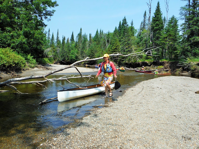
Oct 5, 2015 - BLACKWELL STILLWATER, HUDSON & GOODNOW RIVERS from the Polaris Bridge near Newcomb. Essex Chain Lakes Complex.
Below freezing early this morning but warmed to low 60s. Third of a
mile carry on dirt road gently downhill to the bridge. There is a
campsite on the L a bit before the bridge. Just before the bridge a
path leads 100' upstream to a put-in next to a boulder on river R.
Blackwell Stillwater is about 3 miles long. Short distance to Goodnow
River, got up it for 0.6 miles before rocky shallows after passing a
huge boulder, couple of breached beaver dams on the way. 1 mile
upstream from the bridge on the Hudson reached long stretch of rapids,
stopped for lunch. Back downstream, swift water under the bridge
(upstream travel difficult). Cabins of the Polaris club on E shore. 2
miles from bridge to top of rapids, rock-hopped to center of river for
better view, a bald eagle flew past. Varied shores, some marsh, beaver
ponds & steep forested areas. 8.4 miles.


Oct 4, 2015 - HUDSON & OPALESCENT RIVERS from
CR76 bridge. Hudson River gauge in Newcomb at 2.4'. 1.5 miles to S
end of Sanford Lake where there were good views of Wallface & the
Santanonis, half mile more to mouth of the OR. Got 3 miles up the OR,
hard work against the current, had to get out a few times to line the
canoe thru shallows. Under railroad bridge at 1.7 miles from HR. Lots
of sand/gravel banks offer many places to rest. From HR (between OR
& SL) looking N there was a good view of Algonquin, Colden &
Marcy. Fall foliage close to peak. 10.2 miles. More details on
7-12-15 trip.


Jul 12, 2015 - OPALESCENT & HUDSON RIVERS. MacIntyre East. Hudson River gauge at Newcomb
was at 2.35' this morning - I would not want to do this trip when
levels are much lower. Started at the bridge over the Hudson at
Opalescent Rd, a dirt logging road & gated (at the bridge) access to
hunting camps. Upstream 1 mile on the shallow (1-1.5' deep) Hudson
against a noticeable current soon passing the mouth of the OR to Sanford
Lake, a widening of the river. Before reaching the lake there is a
great mountain view incl. firetower on Adams + Algonquin, Colden &
Marcy. From the S end of the lake Wallface seen to the N &
Santanoni to the W. Back down the HR & up the OR. Got 3.7 miles up
the Opalescent passing under rr bridge at less than half way. Had to
line boats several times thru shallows (but only once going back
downstream). Current was light to moderate. Lots of bends with
sand/pebble banks for break &/or swim. Views of the North River
Mountain range which rises over 2,000' above the river to the SE. Got
out & viewed the river from the RR bridge. Back to the start,
shuttled cars 1 mile S on CR25 then paddled downstream on the Hudson.
Expected to go 2 miles on the river; realized we had missed the best
take-out spot after going 2.5 miles so turned around & paddled
upstream. "Best" take-out was a steep 100 yard bushwhack!. A great
semi-epic outing. 13.4 miles, 7.5 hours. Swift Keewaydin 15 solo
canoe.


RIVERS
AMONGST MOUNTAINS: PADDLING THE UPPER HUDSON AND OPALESCENT RIVERS.
In
April, New York State purchased the 6,200 acre MacIntyre East tract
from The Nature Conservancy (formerly owned by Finch, Pruyn). This
parcel contains over 5 miles of the upper Hudson River not far from
its source as well as 7 miles of the Opalescent River and is located
east of County Route 25, the dead-end road that ends at Upper Works
and a popular trailhead accessing the Adirondack High Peaks area from
the south.
An
area with clear water rivers surrounded by mountains that rise up to
3,600' above those waters makes for a very attractive paddling
destination. On a hot day in July a group of us from the Albany
Chapter of the Adirondack Mountain Club drove up to see what the area
has to offer.
From
Boreas Road (CR 2) we drove north on CR 25 for 4.4 miles, took a
right onto Opalescent Road and very quickly reached a locked gate
ahead of a bridge over the Hudson River. There was room for several
cars to squeeze in off this dirt road. As I understand it, the
public is currently allowed to walk this dirt road for 1.75 miles
past the bridge; beyond that, access is allowed only for private
logging operations and to camp lessees.
I
carried my solo canoe across the bridge and launched below it.
Launching above the bridge might have been a better option so as to
avoid the quickwater that flowed under the bridge. A few mosquitoes
bothered us here but once on the water we were bug-free. Our first
goal was Sanford Lake, a widening of the Hudson River, which is a
mile upstream from the bridge. We soon passed the mouth of the
Opalescent River and paddled against a moderate current in water that
was only a foot to a foot and a half deep.
After
going 0.8 miles and a little before before the lake we enjoyed an
excellent view of Mount Adams with its fire tower and peaking over
its shoulder was Algonquin Peak, the second highest mountain in New
York state; Mount Colden and mighty Mount Marcy, the state's highest,
were also clearly visible. From the south end of the lake one could
see the cliffs of Wallface to the north and the Santanoni Range to
the west. We spent a few minutes sitting in our canoes admiring our
surroundings.
We
then headed back down the Hudson and turned into the Opalescent
River. As is typical of Adirondack streams the Opalescent takes a
convoluted course but uniquely characteristic of the Opalescent are
the many sand and pebble banks that seem to exist at every turn -
these make for great spots to take a break or to go for a swim. The
current was light to moderate and I had to get out and walk my canoe
through pebbly shallows several times but, for the most part, the
water ranged from one to five feet deep.
At
1.7 miles from the Hudson we paddled under a railroad bridge that
used to serve the titanium mine at Tahawus (operations at the mine
ended in 1989). I was happy to find a few ripe blueberries as I was
clambering up to the tracks. The views of the river from the bridge
upstream (with Allen Mountain in the background) and downstream were
lovely.
At
the two mile mark we stopped on a sandy bank for lunch; the shade of
an overhanging maple provided respite from the sun. The North River
Mountains rose up in front of us to the southeast. Most of us also
went for a cool swim at the sandy-bottomed pool below.
We
pushed on upriver and had to get out to walk our boats over more
shallow areas. After traveling 3.75 miles from the Hudson the east
shore grew steeper, a sloping rock was at river's edge and just past
that was a dune-like sand bank, the largest that we encountered on
our route. At this point we were perhaps only a quarter mile east of
the tailings at the old mine but we could just as well have been in
the middle of nowhere.
After
studying maps and satellite images I knew that the river's gradient
started to increase above this point. I was happy getting up as far
as we had gone and it was time to turn back. Paddling downstream my
canoe lightly scraped rocks in the shallows and I only needed to get
out once. It took us one and a half enjoyable hours to ride the
current back out to the Hudson. I did not see much wildlife but the
sounds of white-throated sparrows and hermit thrushes emanated from
the mostly deciduous woods.
Back
at the start, after traveling 9.8 miles to this point, the explorer
in me wanted to experience the Hudson River below the bridge. I
persuaded a couple of companions to continue downstream while others
drove the cars a mile south on CR 25.
The
Hudson River here arcs away from the road before returning toward the
road after about two miles. The river is wider than the Opalescent
and travels between coniferous shores of cedar, black spruce and the
occasional tall white pine. Black-capped chickadees called out from
the woods as we passed by.
Not
seeing the cars we continued at least a half mile past where the road
came nearest to the river but after consulting maps and GPS we felt
it best to paddle back upstream against a light current. We explored
two routes back to the road, neither of which we liked; at best
expect a 100 yard uphill bushwhack, at worst a wet mucky bushwhack
thru a tangled thicket. I was very glad to have seen this section of
the Hudson though.
Our
total distance for the day was 13.4 miles and we spent over seven
hours out in this very scenic area.
The
Hudson River gauge at Newcomb was at 2.35' this morning - I'm not
sure how this relates to the water levels upstream of Newcomb but I
would not want to do this trip when levels are much lower. Just a
few days after this trip the level at the gauge was well below two
feet. I would guess that a gauge level of 2.5 to 3 feet would be
ideal for a trip up the Opalescent - perhaps I should plan a return
trip in the fall.
Sep 20, 2009 - HARRIS LAKES & HUDSON RIVER in Newcomb. It's leaf-peeping time....early fall color. This website makes it sound like an easy trip between Harris & Rich Lakes - we found at least 4 rapids between the 2 lakes from class 1 to class 3 (if enough water)! Geese, ducks, kingfishers, herons, yellowlegs, loon. Couple of small motorboats not too obtrusive; can't say same for the couple of jetskis on Harris - Hudson River was best part of trip. Nice High Peaks views from Hudson River a mile S of Rt.28N bridge. Some development on S shore of Harris. 11 miles, 5 hours.

Sep 25, 2006 - LAKE HARRIS & HUDSON RIVER in Newcomb. Put in at boat launch on Lake Harris Rd. A shallow channel leads from the lake to the river. Downstream (Vanderwhacker Mt. stands out) on Hudson to Long Falls Rapids, turned around to view Marcy, Algonquin & other High peaks; upstream to rapids under bridge. Circuited the lake. Loon. S shore of lake has moderate development. Foliage colors approaching peak. 8 miles, 3.8 hours. Swift Saranac 14.6, a 14'6" touring kayak for the larger paddler.


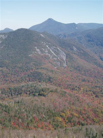
Mon Oct 3 - Mt. ADAMS hike. Tahawus Tract in Southern High Peaks. Very steep trail thru balsam fir & red spruce over final mile to top (make sure you are on red marked trail, a junction is not well signed). No view without climbing the firetower (officially closed) - handrails but no fencing - took me a while before I summoned up the courage to go to the top. Mts. Marcy, Colden, Algonquin, Santanonis, Sewards, etc. - all-encompassing view - Henderson Lake (could see canoes on it), Upper Preston Pond, too. Colors close to peak. Adjustable poles handy for balance & knee-saving on way down (Masters & MSR poles available at APnP). 1,800', 4.8 miles, 4.3 hrs.

HUDSON RIVER SANFORD LAKE canoeing. Put-in next to small 2' dam (~1.25 mi. N of last road junction) & paddled upstream ~1.5 miles - wide at first but became more streamlike - turned around at rapid a little below metal suspension bridge carrying hiking trail across river. Able to go downstream from dam for ~half mile to causeway at mine where 2 culverts (1 blocked, 1 too small) carry the river under. The widening of the river here is called Sanford Lake. Very interesting despite being near road & mine with nice views of Adams & Wallface Mts. Waded thru some shallows - thanks Chota Mukluks.
Oct 6, 2003 - HUDSON RIVER canoeing in Newcomb. Put-in at the end of Santanoni Dr. - wood steps lead down to the river. First spent some time putting Watco oil on the ash gunwales of the Baboosic - you should do this to any unvarnished wood at least once a year. Paddled upstream for about 5 min. & came to a short rapid - lined it to the L (river R) & soon reached a long set of rapids so turned around. Ran the first set of rapids (easy class 2) on river L. Headed downstream for about 1.5 miles then returned - nice scenic section of river but not a lot of fall foliage (this was supposed to be a leaf-peeping trip), shores mostly spruce. GOODNOW MOUNTAIN hike. Moderate 1,000' climb for 1.9 miles - mostly thru hardwoods much of which was still green then spruce/fir near the top. Did not want to leave the firetower (limited views without it) - outstanding, colorful 360 views. High Peaks have about 1' of snow above treeline - the white contrasts nicely with the reds & yellows below.
Sep. 9, 2001 - Hudson River upstream from Lake Harris. Put in from the bridge on campground access road (could paddle from Harris Lake to here, too). A short rocky rapid is below the bridge - need more water to run it (we tried). River averages 100' wide with high sandy banks thru swampy area. Able to paddle less than 1 mi. before reaching 0.5 mi. stretch of rocky class 3 & 4 rapids. Water level very low but we decide to carry about 100 yds. & try a run down. We get hung up on a rock almost right away but once free we manage to negotiate the rest ok (which surprised me). Back to the bridge. Drive to the Hudson River Info Center (turn north at the town park & drive to end of road.) Steep drop to river & wood steps may or may not help. Paddle solo downstream, river lined with spruce spires, occasional glimpses of a High Peak, many sandy banks at this low water level. After 1.5 mi. R shore is posted by the Tahawus Club & soon Beaver Brook enters from the N. Go a little bit further & reach top of rapids of earlier trip. Turn back. Too hot for September - went over to town beach on Harris Lake for a swim. Dagger Reflection 16 ($549 used) is an all-around, medium weight tandem canoe made of durable Royalex. Solo paddled it 3 ways. 1. Kneeling just behind the yoke it was easy to manage but can't remain in that position too long before ankles are killing me. 2. From stern seat: paddled ok but any light wind will make it difficult plus hull shape presented to the water is not the most efficient. 3. Turn canoe around & paddle it "backward" from bow seat. Actually paddled quite well; upstream, too. R16 is an asymmetrical design (as most good, modern canoes are) - the front half of the canoe is very different from the rear half - & in theory should only be paddled "forward". For best performance a kneeling thwart or a center seat should be installed for solo paddling. Some biting flies (they like it hot.)
Visit us on Facebook

.JPG)
.JPG)
.JPG)
.JPG)
.JPG)
.JPG)
.JPG)
.JPG)
.JPG)
.JPG)
.JPG)
.JPG)

.JPG)
.JPG)


Comments
Post a Comment