MINERVA STREAM paddling
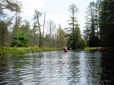
July 26, 2024 - MINERVA STREAM paddle, from the gazebo on CR 30 in Olmstedville. Elevation 1140'. Good water level. Mostly wild shores but hints of civilization here and there - mostly quiet & peaceful, pretty. Beaver dams about every half mile - had to get out & pull over for most going upstream but able to run or scooch over all but the one biggest on the way back downstream. Tempting backwaters along the way. Flowering: Joe Pye weed, cardinal flower, steeplebush, buttonbush, goldenrod, yellow pond lily, fragrant white lily, smartweed, purple loosestrife. Mostly grassy shores, when trees came close they were often cedars & white pines. Peaks in view: Moxham, Gore, Green, Snyder, Oliver, Hayes. Paddled under 2 road bridges: CR 30 (you can launch there too) & O'Neill Rd (you can put in at the transfer station). Saw 2 solo paddlers. No bad bugs. Temp rising thru the 70s, mostly sunny, breezy. 9.4 miles, 5.3 hours.
Sep. 28, 2001 - Minerva Stream, Olmstedville. Put-in is on CR 30 a little NW of Olmstedville. Next to a bridge is a wood "Canoe Site" sign. Paddled upstream 3 mi. & under a road bridge near Irishtown. 5 or 6 beaver dams in this section, changing shoreline is definitely more "Southwoods" than the "Northwoods" of the Bog & Oswegatchie. A lot of smaller white pines border the marsh. Continued upstream for a couple of miles & over 8 or 9 more beaver dams (saw 3 beavers) - this section is prettier with Green Mtn. in view most of the time to the NW. Snyder & Oliver Hills dominate the E. The dome of Hayes Mt. to the N. Never more than a half mile from a road but the stream has a good wilderness feel. Could have kept going over more beaver dams. Scouted out by car further upstream - trail to Lester Flow parallels the stream (not paddleable tho).


Comments
Post a Comment