PEAKED HILLS bushwhack hike in the Hoffman Notch Wilderness, Adirondack Park NY + ski to pond W of Wyman Hill

Mar 5, 2022 - Started at the Dirgylot Hill trailhead (el 885'), woods road thru giant culvert under the Northway. 0.7 miles to a T, then R. Gain (gross uphill travel) of 213' in 1st mile (makes for a fun run out at the end of the day). The woods road soon fades into a path marked with ax blazes & leaning sticks - noted some cedars in here & some large white pines. Steep drop to a stream crossing & steep uphill to pick up the path again. Gain of 177' in 2nd mile. Joined an old road that parallels 17th Brook - now climbing moderately, sometimes steeply - some lovely ash trees in this stretch, unfortunately some were blowdown across our route & made the going more challenging. Gain of 459' in our 3rd mile. The old road finally levels out a bit & is quite clear going thru softwoods. Our highest elevation 1,705'. Crossed the brook & bushwhacked N to a small remote pond that lies W of Wyman Hill. Gain of 115' in 4th mile. Got thru-the-trees views of Hoffman Mtn & the Peaked Hills. The ski back down was semi-epic, I only fell once. Very good to excellent skiing on 4"-8" powder on top of good base, temp rose above freezing in the pm & the snow got a bit sticky. Gross elevation gain 1,119', 8 miles, 5.8 hours.


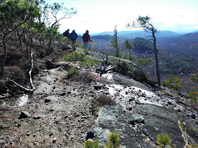
Nov 1, 2021 - PEAKED HILLS, eastern Hoffman Notch Wilderness, from Dirgylot (someone please tell me what that word means) trailhead. Starts out on an old woods road, thru a large culvert under the Northway, takes a R on old road then becomes a path with some axe blazes. Brook crossing a bit tricky due to recent rains. The old road becomes more obvious as we slowly gain elevation, raging 17th Brook w/waterfalls on our R. Bushwhacked SW then S up ridge to the NE peak, hardwoods transitioned to spruce & cedar near the top at 2,274' el, a net gain of 1,314' from start. Views S (Jones Hill, Crane Mtn, & Schroon Lake), W (Hoffman Mtn, west Peaked Hill), & N to the High Peaks. The only sight of civilization was the runway at Schroon airport. Dropped down to the W then S & up to the SE peak which had views from several rocky spots below the summit, the summit (2,160') had lots of small red pines. Dropped down to the E, got a view to Pharaoh Mtn, & eventually picked up a small brook & down to our previous brook crossing, then path + old road out. 7.9 miles, 6.6 hours.


Comments
Post a Comment