CAT & THOMAS MOUNTAINS hike
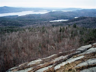
June 27, 2024 - Hike from Trout Lake to ledges on the south side of CAT MOUNTAIN. Start out going along the edge of a residence, soon see LGLC signs. Continued on the old 4WD trail (unmarked, possibly an old town road), sometimes rocky, sometimes wet, going N then curving to the W. Passed some beaver swamps ("pond" would be too kind) mostly on the S side. Went off-trail heading N. Very steep. Soon saw old white paint blazes, lost them 3x. Stayed to the L of a rock wall/cliff. At ~1750' (only 200' below the summit), turned E & soon found a good lookout to the W - Crane Mtn stood out. Found some ripening blueberries. Downhill to the SE & got lucky with a view to Lake George. Dropped steeply S. Saw some mostly small chanterelles - snagged the biggest one. Picked up the old 4WD trail E of where I had left it & out. 4.6 miles, 1037' el gain, 3.6 hours. Partly sunny, temp in the upper 60s to low 70s, dewpoint dropping thru the 50s. Deer flies showing their presence.
Oct 31, 2022 (Mon) - Loop hike from Edgecomb Pond. Walked in ~0.3 miles & took a L on the old trail that had red trail blazes but now it seems like DEC has painted them over in black (altho they missed a few) to discourage the use of this route. However, for the most part, it was still relatively easy to see the blazes - some attention was needed at times because the trail makes some unexpected turns. Rolling terrain at first, then it starts serious climbing but eases up occasionally & views opened up. 1.8 miles & 1.5 hours to the summit. Lots of ups & down & a spur to a view W to Crane Mtn on the yellow trail, then a final steep climb to the lookout on Thomas (saw spotted knapweed flowers). Down on a rocky old woods road (saw some heal-all flowers) to a junction (saw 2 hunters, the only other people we saw on the hike), then a R on a woods road past a pond with a view of Cat, & back to start. Lots of leaves down - slippery at times & hides the foot tread so caution is advised. 7.7 miles, 5.8 hours.
April 27, 2021 - Started from Edgecomb Pond (1,050'), loop hike clockwise. The area became state land in 2013. 2.3 miles to Cat Mtn (1,956'), much of the route on old logging trails, steeper near the top. Very good views of Lake George around to Crane & Gore to the west. Yellow Trail with lots of up & downs along ridge (saw 2 hairy woodpeckers) to the lookout ledge (1,940', there used to be a cabin there, removed in 2017) on Thomas, 2.5 miles from Cat - view of LG, Cat & better view of Crane - less civilization in view than Cat. Noticed some pitch pines near the ledge. Down (nice to be working with gravity) on logging roads - yellow, then R on blue. Passed a pond with view of Cat. 7.9 miles, ~1,800' el gain, 5.4 hours. Popular trails so went on a Tuesday, saw a few people on the trails but had the viewpoints to myself. Did not see any wildflowers.
Nov 25, 2010 - CAT MOUNTAIN hike. Start on Valley Woods Rd not far E from Northway Exit 24. May not have gone above freezing, some ice in the trail (old logging roads) easily avoided. Trail gets rougher the farther you get. Pass some icy beaver ponds, one with a view of Cat & also expanding onto the trail. Gain of over 700' from the trailhead. Great views of the southern half of Lake George, Green Mountains, Crane & Gore (making snow on 2 trails) Mtns, Mt Greylock?. Could also see the cabin on Thomas Mtn to the N. XC skiing would be easy on 1st 2+ miles but the climb over the final mile would make it advanced, plus you would need at least 1.5' of snow to cover all the rocks. 6.5 miles, 4.4 hours.
Feb 9, 2009 - THOMAS MOUNTAIN. Stopped at Lake George Rec Center - not groomed, icy hard, skied a loop, not much fun. Drove over to Thomas trailhead on Valley Woods Rd. Trail was packed hard & I could have bare-booted the whole way without post-holing but donned snowshoes for the grip of their crampons. Great view from the cabin near the top: south end of Lake George, Cat Mtn not far to the S, Crane & Gore Mnts to the W. Enjoyed the sun on the cabin porch for 1.5 hours. Explored a bit - sunk up to 1.5' even with snowshoes on off-trail. Some distant road noise (I-87 is ~1 mile away). 700', 3 miles, 3.6 hours.


.JPG)
.JPG)
.JPG)
.JPG)
.JPG)
.JPG)
.JPG)
.JPG)


Comments
Post a Comment